Aviation weather is one of the single most important factors pilots must understand before, during, and after every flight. Weather affects aircraft performance, navigation, communications, and pilot workload. A solid working knowledge of basic meteorology helps pilots make safer go/no-go decisions, manage in-flight risks, and communicate clearly with air traffic control and dispatch.
This article explains the core aviation weather concepts pilots need to know, translates technical terms into practical decision-making tools, and highlights common pitfalls to avoid. Whether you are a student pilot working toward your first cross-country or an instructor mentoring complex weather scenarios, the information here is organized to support flight planning, in-flight recognition, and sound aeronautical judgment.
Core Aviation Weather Concepts
Understanding a few foundational concepts provides the framework for interpreting METARs, TAFs, pilot reports, and weather briefings. Key elements include pressure systems, fronts, stability, moisture, and the vertical profile of the atmosphere.
Pressure systems are large-scale patterns of rising and sinking air. Low-pressure systems usually bring clouds, precipitation, and more dynamic weather. High-pressure systems generally bring clearer skies and lighter winds. Fronts are the boundaries between air masses of different temperature and humidity. A cold front typically produces a narrow zone of convective activity and gusty winds, while a warm front often produces widespread cloudiness and steady precipitation.
Atmospheric stability describes whether an air parcel tends to continue rising or fall back to its original level. Unstable air supports vertical motion, which is the mechanism behind cumuliform clouds and turbulence. Stable air suppresses vertical motion and favors stratiform clouds and smooth conditions. Moisture availability, measured by relative humidity and dew point spread, determines whether clouds will form when air rises and cools.
Why This Matters in Real-World Aviation
Weather shapes virtually every operational decision. Density altitude affects takeoff and climb performance. Wind direction and strength influence runway selection, crosswind considerations, and fuel planning. Icing conditions can rapidly degrade lift and add weight. Low ceilings and reduced visibility are direct threats to approaches, departures, and VFR navigation. Recognizing how these elements interact is essential to avoid getting surprised in flight.
Experienced pilots integrate weather knowledge into risk management. They anticipate how conditions will evolve along the planned route, identify alternatives, and plan fuel reserves and diversion options. Flight instructors should emphasize how weather trends and vertical profiles influence aircraft handling and systems, not just how to read an individual report.
How Pilots Should Understand Aviation Weather
Interpreting weather for flight operations means combining raw products with practical judgment. Here are the practical components pilots should master:
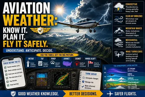
1) Observations. METARs provide current ground conditions at airports: wind, visibility, cloud ceilings, precipitation, and temperature/dew point. Trend indicators and recent weather remarks can reveal rapidly changing conditions.
2) Forecasts. TAFs and area forecasts give expected conditions over time. Recognize windows of deteriorating or improving weather and how probability and timing affect go/no-go decisions.
3) Pilot reports. PIREPs and real-time pilot observations can confirm or contradict automated products, especially for turbulence, icing, and cloud bases over terrain.
4) AIRMETs and SIGMETs. These advisories highlight widespread or hazardous conditions for transits and approaches, such as moderate icing, turbulence, mountain obscuration, or convective activity. Learn the general triggers and typical operational implications rather than memorize arcane thresholds.
5) The vertical profile. Surface observations alone are not enough. Examine sounding data or pilot reports that show temperature, dew point, winds aloft, and freezing levels. This helps predict icing levels, turbulence layers near fronts or mountains, and potential convective development.
Common Mistakes or Misunderstandings
Pilots often make predictable errors when evaluating weather. Recognizing these helps reduce risk:
Assuming surface conditions represent the entire route. Conditions often vary significantly with altitude and distance. A calm surface can hide strong winds aloft; a clear surface can hide a low-level inversion that traps moisture and produces fog elsewhere along the route.
Over-relying on a single product. METARs, TAFs, satellite imagery, radar, and PIREPs each provide different perspectives. Use them together to form a layered picture. A single favorable TAF window does not guarantee safe conditions if surrounding areas show convective trends.
Underestimating the rate of change. Frontal passages, sea breezes, and convective growth can alter conditions quickly. Trend remarks and radar should inform dispatching and in-flight decisions, particularly for cross-country or mountainous flights.
Failing to consider aircraft limitations and pilot proficiency. Even moderate turbulence or light icing can be unsafe for light aircraft or inexperienced pilots. Match the expected conditions to the aircraft’s certified capabilities and your recent experience and training.
Practical Example
Imagine planning a morning cross-country from a coastal airport to an inland field 200 nm away. The METAR at departure shows clear skies, light winds, and a temperature-dew point spread of 12 degrees Celsius. The TAF predicts a warm front passing mid-morning with lowering ceilings and increasing southerly winds. Winds aloft forecasts show a strong southerly flow at cruise altitude, and PIREPs from aircraft ahead report light turbulence at the planned cruise altitude.
Apply practical weather judgment: anticipate a wind shift and stronger headwind on the return, prepare for lower ceilings and potential instrument conditions near the frontal boundary, and consider departing earlier to avoid the frontal passage. Identify alternate airports with higher ceilings, brief the flight on how to transition between VFR and IMC if qualified, and monitor radar and updated forecasts en route. If single-pilot and marginal on the day, electing to delay or choose a lower-risk route is a sound operational decision.
Best Practices for Pilots
Weather proficiency grows through study, practical use, and structured training. Adopt these habits:
- Start weather briefings early and update them frequently before departure and en route.
- Learn to decode METAR and TAF shorthand quickly and accurately; practice with real reports.
- Use multiple sources: official briefings, radar/satellite/apps, PIREPs, and ATC updates to build a complete picture.
- Understand the limitations of automated observations, especially at airports with complex terrain or few sensors.
- Plan for alternates and fuel contingencies based on likely weather changes, not just current conditions.
- Practice weather scenarios with an instructor, including unexpected closure of a planned destination or encountering unforecast icing or turbulence.
Frequently Asked Questions
How should I use METARs and TAFs together?
METARs tell you current conditions at observation sites; TAFs provide forecasted changes for specific airports. Use METARs to confirm present state and TAFs to understand timing and probability of expected changes. When they conflict, prioritize recent observations and PIREPs while monitoring updated forecasts.
When is icing most likely to be hazardous to small aircraft?
Icing risk increases when visible moisture and temperatures near or below freezing exist along the flight path. Pay attention to freezing level forecasts and temperature aloft. Even light structural icing can degrade performance; avoid areas where icing is expected if the aircraft is not certified or equipped for known icing.
What is the best way to prepare for convective (thunderstorm) weather?
Treat convective weather as high risk. Avoid flying through or near thunderstorms. Use radar and convective outlooks to plan detours, maintain large lateral and vertical margins, and delay or cancel flights if convective coverage is significant along the route.
How do winds aloft affect my fuel and time planning?
Winds aloft directly influence groundspeed. Headwinds reduce groundspeed and increase fuel burn and time en route; tailwinds do the opposite. Check winds at planned cruise altitudes and consider changing altitude if the aircraft and ATC allow and if a better wind layer exists.
Are AIRMETs relevant to general aviation pilots?
Yes. AIRMETs inform pilots about widespread conditions that can affect VFR or light IFR operations, including moderate turbulence, icing, or instrument conditions near mountains. Understand their content and how it applies to your aircraft and route.
Key Takeaways
- Practical takeaway: Combine METARs, TAFs, winds aloft, and PIREPs to build a layered, time-based picture of expected conditions.
- Safety takeaway: Always match expected weather to aircraft capability and personal proficiency; avoid marginal conditions when single-pilot or unfamiliar with a weather hazard.
- Training and decision-making takeaway: Practice weather scenarios with an instructor and rehearse diversions, fuel contingencies, and transition from VFR to IFR operations.