Pilots navigate without GPS by using a mix of traditional techniques and onboard electronic navigation aids. Whether a handheld GPS fails on a VFR cross-country or an aircraft experiences an IFR GPS outage, sound pilotage, reliable instrument cross‑checks, and knowledge of radio navigation allow you to maintain course, meet airspace requirements, and get to a safe landing. This article explains how pilots navigate without GPS and why these skills remain essential for safety and airmanship.
Understanding non‑GPS navigation prepares you for equipment failures, signal outages, or situations where GPS service is limited. The techniques described here are practical for student pilots, flight instructors, professional aviators, and serious enthusiasts who want to strengthen basic navigation, situational awareness, and decision making.
Core Methods Pilots Use When GPS Is Unavailable
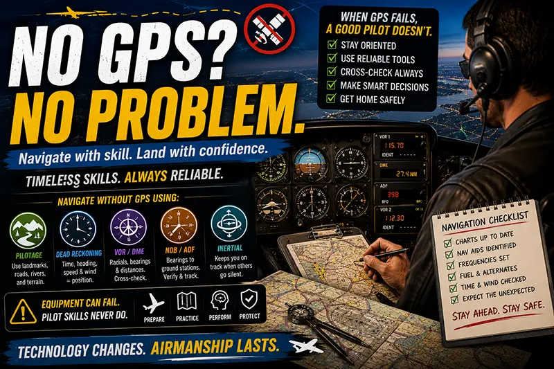
When GPS is unavailable, pilots rely on a combination of pilotage, dead reckoning, visual navigation, and ground‑based instrument navigation. Each method has strengths and limits, and good navigators combine them to cross‑check position and heading.
Pilotage is navigation by visual reference to landmarks shown on charts. Look for highways, railroads, rivers, lakes, coastline, towns, and other prominent features. Effective pilotage requires up‑to‑date charts, good visibility, and continuous position scanning.
Dead reckoning uses time, heading, speed, and wind estimates to compute position from a known starting point. It is essential when visibility is reduced or when flying over terrain without prominent landmarks. Dead reckoning requires accurate timekeeping, an understanding of wind effects, and periodic verification with other references.
Radio navigation includes VOR (VHF Omnidirectional Range), NDB (Non‑Directional Beacon) with ADF (Automatic Direction Finder), VOR/DME fixes, and distance measuring equipment. These systems allow position fixes and tracking along airways or radials. Onboard navigation receivers display course deviation, bearing, or distance to a facility. Understanding how to tune, identify, and interpret these instruments is critical when GPS is out.
Inertial navigation systems and integrated flight guidance systems found on larger aircraft provide another layer of navigation when GPS is degraded. These systems maintain a position solution for some time but can drift and need periodic updates from ground systems or pilot inputs.
Why Non‑GPS Navigation Still Matters in Real‑World Aviation
Modern avionics and satellite navigation are reliable, but no system is immune to failure. GPS outages may be caused by equipment failure, interference, intentional outages, or loss of service in certain environments. Airports and airways still depend on ground‑based navigation infrastructure. Pilots who can navigate without GPS are better prepared for in‑flight contingencies, can comply with ATC instructions, and can make safer decisions during diversions.
Training and test standards expect airmanship that includes instrument scan discipline, compass and heading control, and proficiency with radios and charts. For commercial operations and complex flights, procedures for GPS loss or degradation are part of company training, and regulators require contingency strategies. Practically, this means the ability to transition from an RNAV‑based plan to VOR/DME or pilotage when needed.
How Pilots Should Understand and Apply These Techniques
Approach non‑GPS navigation as layered tools rather than isolated techniques. Use pilotage to verify position whenever appropriate, and use dead reckoning to drive your expected track when visual cues are scarce. When using radio navigation, always identify the station and understand the instrument’s indications, including limitations like line‑of‑sight for VHF and signal bearing errors close to the station.
Practice partial panel flying and non‑precision navigation in good weather so the procedures become second nature. Simulate GPS outages during cross‑countries or dual flights, switch to VOR tracking, and practice calculating headings and times for dead reckoning. Develop a routine for reestablishing position: tune a known VOR, check DME if available, compare with ground references, confirm identifications, and communicate with ATC if IFR.
Key Navigation Tools and How They Work
Understanding the instruments and resources available helps you choose the right method in the moment.
Magnetic Compass and Heading Instruments
The magnetic compass provides an absolute bearing reference and is essential when electrical failures affect gyros. It is subject to errors such as turning error, acceleration error, and variation. Use short, smooth turns and interpret the compass in conjunction with the heading indicator, which must be periodically realigned to the magnetic compass.
VOR Navigation
VOR receivers display radials relative to the station and enable tracking inbound or outbound. When navigating without GPS, you can intercept and track VOR radials, navigate along airways, or determine position using intersections created by two or more VOR radials. Always identify the VOR by listening to its Morse code identifier and consider limitations: VOR reception is line‑of‑sight, which means distance depends on altitude and terrain.
NDB and ADF
NDB stations transmit nondirectional signals that the ADF points toward. ADF navigation is more susceptible to weather, electrical disturbances, and night errors near coastal areas. Still, it provides a useful bearing to a ground station and can be used for approaches or fixes when other aids are unavailable.
DME (Distance Measuring Equipment)
DME provides slant range distance to a paired ground station. When paired with a VOR, VOR/DME lets you determine both bearing and distance, making fixes and DME arcs possible. Slant range error is greatest at low altitude directly over the station and should be considered during low‑altitude fixes.
Inertial and Radio Inertial Systems
In larger aircraft, inertial navigation systems compute position by integrating accelerations. These systems can maintain navigation for some time without external input but drift over time. They are valuable when satellites or ground stations are degraded. Pilots should understand their limitations and how to cross‑check them.
Common Mistakes and Misunderstandings
Pilots sometimes misunderstand the limitations of non‑GPS techniques or make procedural errors that increase risk. Recognizing these pitfalls helps reduce error and mitigate incidents related to navigation failures.
One common mistake is overreliance on GPS with insufficient proficiency in backup methods. If GPS becomes unavailable, a pilot who has not practiced pilotage or VOR tracking may be slow to recover position, increasing workload and stress.
Another frequent error is poor wind planning in dead reckoning. Mistakes in estimating wind direction and speed lead to heading and timing errors. Use weather briefings and onboard wind calculation tools where available. When you are uncertain, plan conservative margins for fuel and distance.
Misidentification of radio aids is also a prevalent problem. Pilots must always confirm a VOR’s Morse identifier or the ADF frequency’s station ID. Tuning the wrong frequency or forgetting to identify the station can produce catastrophic position errors.
Compass and instrument errors can mislead pilots if not cross‑checked. Magnetic deviation, unreliable gyros, and compass errors during accelerations or turns require interpretation and confirmation with other references.
Practical Example 1: VFR Cross‑Country GPS Failure Over Mixed Terrain
Scenario: You are on a VFR cross‑country at 5,500 feet when your handheld GPS loses power. You are not on a published airway and are flying over mixed farmland and sparse roads. Your first step is to maintain straight‑and‑level flight and clear the area for traffic while you regain situational awareness.
Start by orienting with the sectional chart. Identify any visible large features such as a river, county roads, or a town. Use pilotage to find a recognizable intersection or landmark. If visibility is limited, begin dead reckoning from your last known position: note the time since the last reliable fix, your true airspeed, and estimated wind to compute the estimated position.
If you are uncertain about location or approaching congested airspace, communicate with ATC or UNICOM, provide position information based on landmarks, and request assistance if needed. Do not press on into deteriorating conditions. A conservative diversion to the nearest suitable airport for reorientation and equipment assessment is often the safest choice.
Practical Example 2: IFR GPS Failure on an En Route Segment
Scenario: While on an IFR flight plan, GPS fails and your primary navigation becomes unreliable. Inform ATC with a brief transmission identifying the equipment problem. ATC can provide radar vectors, assign VOR or VOR/DME routing, or clear you to the nearest suitable fix.
Switch to VOR navigation: tune and identify a nearby VOR, intercept a radial, and use cross bearings with a second VOR to establish position. If DME is available, use distance checks to validate your estimate. If neither VOR nor DME are available, request radar vectors or proceed on a cleared direct to a fix you can identify by other means.
Remember that ATC may not immediately be able to provide a route identical to your planned RNAV route. Be ready to accept vectors or to fly an alternate routing. Verify altitude constraints, airspace transitions, and terrain clearance while you work the navigation problem.
Best Practices for Pilots
Adopt these habits to be prepared for GPS outages and navigation issues.
- Plan backup navigation: Before flight, identify available VORs, NDBs, and prominent pilotage features along your route. Know the frequencies and check the minimum reception altitudes if applicable.
- Practice regularly: Simulate GPS failures during training flights. Practice pilotage, dead reckoning, and VOR tracking under instructor supervision so the skills remain sharp.
- Keep charts current and accessible: Ensure your sectional, IFR en route, and terminal charts are up to date and easily reachable in the cockpit.
- Manage workload: When GPS fails, fly the airplane first, stabilize the aircraft, and then work the navigation problem methodically.
- Communicate early: Tell ATC or advisory frequencies about your equipment status and accept assistance when needed. Clear, concise communication reduces workload and helps controllers provide effective support.
- Use time and distance checks: For dead reckoning, use a reliable timepiece and calculate distance traveled. Regularly cross‑check estimated position with visible landmarks or radio fixes.
- Understand instrument limitations: Know how your VOR, ADF, and DME behave near the station and under different reception conditions. Expect line‑of‑sight limitations and signal errors.
Training and Currency Recommendations
Pilots should routinely include non‑GPS navigation in dual instruction and personal proficiency flights. Flight training syllabi commonly include VOR tracking, pilotage, and compass navigation for this reason. For instrument pilots, partial panel and lost‑comms procedures should be practiced regularly so that a loss of GPS does not lead to a loss of control or situational awareness.
For commercial operators and airline pilots, company procedures outline contingency actions for GPS loss. Be familiar with those procedures and ensure recurrent training covers the scenario of degraded or unavailable satellite navigation.
Common Equipment and Cockpit Setup Tips
Keep your navigation panel organized for rapid reversion. Label frequencies and have copies of common approach plates or DPs ready when flying IFR. If you fly with a passenger or crew, brief them on how they can assist, for example by reading charts, tuning radios, or keeping time.
For VFR operations, keep a reliable handheld radio and a charged backup battery for portable devices. Store sectional charts in a map case or tablet with an independent power source. For IFR, verify that navigation receivers are functional during preflight checks and understand how to use standby instruments.
Common Mistakes, Misunderstandings, and Safety Risks
Pilots sometimes assume GPS outages are rare and prepare inadequately. This leads to several safety risks: continued flight into instrument meteorological conditions without reliable navigation, extended time in unfamiliar airspace, and poor decision making under high workload. Other mistakes include misinterpreting ADF indications at night, failing to account for slant range error when using DME close to a station, and not cross‑checking VOR identifications.
Operationally, a failure to notify ATC promptly can create conflicts and delay assistance. Fatigue and stress during an equipment failure can impair judgment, so practicing cockpit resource management and error‑tolerant procedures reduces operational risk.
Frequently Asked Questions
Can I legally fly IFR without GPS?
Yes, many IFR flights are routinely conducted without GPS using VOR, localizer, and other ground‑based navigation aids. However, the ability to fly without GPS depends on equipment, the filed route, and current procedures. If your planned route or approach requires GPS‑based RNAV capability, flying without it may not meet the required navigation performance for that route or approach.
How do I calculate a wind correction for dead reckoning?
To calculate a wind correction, estimate or obtain wind direction and speed, determine true airspeed, and compute the drift angle required to maintain your desired ground track. Many pilots use a flight computer or E6B for rapid computation. Remember to apply the corrected heading and to recompute groundspeed and time en route for fuel planning.
What is the most reliable non‑GPS backup method?
The most reliable method depends on the flight context. For VFR in good visibility, pilotage with chart cross‑checks is highly reliable. For IFR or at night, VOR/DME provides dependable fixes when within reception range. Maintaining proficiency across methods is the best defense.
How do I verify a VOR station?
Always verify a VOR by listening to its Morse identifier on the audio channel or observing the automatic station ID if your equipment provides it. Confirm the VOR is the correct facility before using it for navigation.
Are handheld GPS units useful as backups?
Handheld GPS units are useful but should not be the only backup. They can fail due to battery, antenna, or software problems. Treat them as supplemental and ensure you can navigate without them.
Key Takeaways
- Practical takeaway: Combine pilotage, dead reckoning, and radio navigation rather than relying on a single method when GPS is unavailable.
- Safety takeaway: Fly the airplane first, communicate with ATC early, and choose conservative diversions if position is uncertain.
- Training takeaway: Regularly practice non‑GPS navigation and partial panel procedures to maintain proficiency and reduce workload in real contingencies.
Non‑GPS navigation is not nostalgia. It is a modern pilot skill set that complements satellite navigation and provides resilience for real world operations. Regular practice, sound preflight planning, and calm, methodical in‑flight technique will keep you safe and competent when technology fails.