Aviation charts are the maps pilots use to navigate the airspace, plan safe flights, and make real-time decisions in the cockpit. When most pilots hear the term "charts," they think of the familiar VFR sectional. Sectionals are essential, but a full operational picture requires more chart products, instrument publications, and supporting data. Understanding aviation charts beyond sectionals increases situational awareness, improves decision-making, and reduces surprises during cross-country flights, approaches, and operations in complex airspace.
This article explains the main chart types that complement or replace sectionals for specific missions, how to interpret the information they present, and how to apply chart knowledge in the cockpit. The discussion covers VFR terminal area charts and WACs, IFR enroute charts, approach plates and airport diagrams, instrument departure and arrival procedures, chart supplements and facility data, and how NOTAMs and GPS databases interact with charted information. Pilots, instructors, and aviation professionals will find practical examples, common mistakes, and training recommendations to build chart competence beyond basic VFR navigation.
Core chart types and what they add to the sectional
Sectionals are optimized for VFR navigation at low altitudes and they present a blend of topography, airspace boundaries, radio navigation aids, and airport information. Other chart products add specialized detail or display the same information at different scales and formats that are crucial for specific phases of flight.
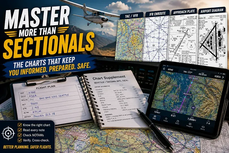
Key chart types to know beyond the sectional include:
- Terminal Area Charts (TAC) - Higher scale VFR charts for busy terminal areas. They show more detail around major airports, including complex airspace, surface features, and congested traffic patterns.
- World Aeronautical Charts (WAC) - Lower scale charts for longer-range VFR navigation. WACs cover larger areas and are useful for planning and cross-country navigation at higher altitudes where detail density is less critical.
- IFR Enroute Charts - Low and high altitude enroute charts for instrument flight. They show Victor airways, jet routes, minimum enroute altitudes, navigation fixes, and airway intersections essential for IFR route planning.
- Instrument Approach Procedures (Approach Plates) - Procedure charts that document instrument approaches, missed approaches, and required minima for landing at airports under instrument conditions.
- Standard Instrument Departures (SIDs) and Standard Terminal Arrival Routes (STARs) - Published procedures for controlled transitions between terminal airspace and the enroute environment. They include lateral and vertical guidance and sometimes altitude crossing restrictions.
- Airport Diagrams - Detailed airport surface layouts used for taxi planning and runway awareness. They display taxiways, runways, hot spots, and apron or ramp areas.
- Chart Supplement and Facility Publications - The Chart Supplement (formerly Airport/Facility Directory in some regions) contains longer textual entries about airports, services, frequencies, lighting, and operational considerations not included on graphical charts.
- Obstruction and Terrain Charts - Specialized charts or layers (including digital terrain and obstacle databases) that emphasize vertical hazards, terrain elevation, and obstruction lighting for safe altitude planning.
Each of these charts uses different scales, symbology, and conventions. Learning to move between them and to integrate their information into a single mental model is the skill that elevates navigation from following checkpoints to proactive risk management.
Why this matters in real-world aviation
Flight operations expose pilots to a wide range of environments. A cross-country VFR flight through uncontrolled airspace is different from an IFR departure in mountainous terrain or an approach into a busy Class B terminal area. Using only the sectional in all cases increases workload and risk because the sectional does not present some critical procedural and regulatory details that IFR and terminal charts provide.
Consider time-critical situations: entering a complex terminal area late, receiving an unexpected IFR clearance, or reacting to rapidly changing weather. A pilot who is comfortable with multiple chart products can scan, interpret, and apply the correct procedural information quickly. That skill matters for safety, for meeting ATC expectations, and for complying with airspace restrictions.
Understanding the relationships among charts, charted procedures, and real-time data sources reduces common errors such as misidentifying airspace, selecting an inappropriate altitude for terrain clearance, or mis-executing an approach. For flight instructors, teaching students how charts complement one another is a core part of developing well-rounded, prepared pilots.
How pilots should understand and use these charts
Learning to use multiple chart types is not about memorizing every symbol. It is about understanding the purpose of each chart, the conventions they use, and where to look for the critical details that affect your flight. Here is a practical way to think about chart selection and usage:
Preflight, decide your primary navigation baseline. If flying VFR cross-country at low altitude, the sectional or TAC may be your baseline. If you expect to fly higher or need lower-detail coverage over a long distance, include WACs. If flying IFR or expecting IMC, build your plan around IFR enroute charts and the applicable approach plates for your destination and alternates.
During flight, use the most relevant chart for the immediate phase of flight. Enroute charts inform airway alignment and minimum altitudes. Approach plates provide step-by-step guidance for instrument approaches and missed approaches. Airport diagrams are used for ground navigation. Keep the chart that you need most readily accessible and the supporting charts available for quick reference.
When using digital chart systems, be aware of how different layers are displayed and how database updates affect the information shown. Electronic flight bags and panel-mounted moving maps can present multiple chart types, but they also can hide critical details when zoom level or layer configuration changes. Cross-check what the device presents with a printed or alternate digital source when the situation demands high assurance.
Common mistakes and misunderstandings
Pilots often make three types of errors when they rely solely on sectionals or fail to understand other chart products: scale and detail mismatch, procedure misinterpretation, and overreliance on a single data source.
Scale and detail mismatch occurs when a pilot expects the same level of feature detail on different charts. For example, a WAC will not show small airports and obstructions that a sectional or TAC does, which may lead to navigational surprises. Conversely, expecting every feature on a sectional to match an approach plate will cause confusion because procedural charts prioritize obstacle and procedural information over general terrain shading.
Procedure misinterpretation is common when pilots do not read the notes, restrictions, or textual segments of approach plates, SIDs, and STARs. These items often contain altitude constraints, crossing restrictions, or pilot action requirements that are essential for safe execution. Mistaking a suggested altitude for a mandatory crossing altitude, or overlooking a missed approach routing, can create hazardous situations.
Overreliance on a single data source becomes especially risky when using GPS displays alone. GPS navigation and charting databases are powerful, but they depend on database currency and device configuration. Not all GPS units will depict temporary restrictions such as TFRs, or they may display an annotated procedure with different symbology than a printed plate. Cross-check chart supplements, NOTAMs, and ATC instructions when operating in dynamic conditions.
Practical example: planning and executing a mixed VFR-IFR cross-country
Scenario: A pilot plans a daytime cross-country from a small VFR field to a busy metropolitan airport with an IFR alternate on standby. Weather is marginal VFR near the destination and an instrument approach may be needed. How should the pilot use charts beyond the sectional to prepare?
Preflight steps:
- Start with the sectional to establish a VFR route and identify notable checkpoints and controlled airspace boundaries along the route.
- Obtain the IFR low enroute chart relevant to the planned routing and identify Victor airways, fix names, and minimum enroute altitudes. Even if filing VFR, knowing IFR altitudes helps evaluate terrain clearance if the flight becomes IMC.
- Download the approach plates for the destination and the planned alternate. Read the approach minima, missed approach procedures, and any supplier notes that may affect aircraft or pilot requirements. Check the airport diagram for runway lengths, declared distances, and taxiway layout.
- Review the Chart Supplement entry for the destination and alternate airport to confirm frequencies, lighting, services, and runway surface conditions that do not appear on approach plates or sectionals.
- Check NOTAMs for temporary runway closures, taxiway changes, and TFRs that may affect approach or arrival. Confirm that the GPS navigation database is current for RNAV procedures you plan to use.
In-flight application:
If weather deteriorates and an IFR clearance is obtained, transition to the IFR enroute chart and the selected approach plate. Use the charted missed approach procedure as the initial contingency plan in case visual contact is lost during final approach. If the airport is in Class B airspace, reference the TAC or sectional inset to manage airspace transitions during descent and approach. After landing, use the airport diagram for safe taxi planning, paying attention to taxiway closures listed in NOTAMs or depicted in the diagram.
This layered approach to chart use ensures that the pilot has relevant information at every stage and reduces the chance of being caught without procedural or airport-specific detail when circumstances change.
Best practices for pilots when using multiple charts
Good chart discipline reduces workload and improves safety. These best practices help pilots integrate multiple chart products effectively.
- Plan with multiple charts. Preflight planning should include the sectional or TAC, the appropriate enroute chart, approach plates for destination and alternates, the Chart Supplement, and a current NOTAM list.
- Prioritize critical documents. Keep the chart that supports the current phase of flight most accessible and have secondary charts readily available for quick reference.
- Understand symbology differences. Learn the common symbols and annotation conventions used on approach plates, enroute charts, and sectionals so you can interpret them quickly under pressure.
- Cross-check multiple sources. Confirm frequencies, runway information, and special procedures by cross-referencing the Chart Supplement, NOTAMs, and the latest published plates.
- Use print and digital backups. Relying solely on one medium can be risky. Have a printed approach plate or airport diagram available if possible, and ensure electronic devices have current databases and sufficient battery power.
- Practice procedural execution on the ground. Walk through SIDs, STARs, and approach plates during preflight and in the simulator to reduce surprise during execution.
- Teach and learn context. Flight instructors should integrate multi-chart training early so students learn to pick the right tool for the flight condition and phase.
Integration of NOTAMs, Chart Supplement content, and digital databases
Charts represent published information. NOTAMs and Chart Supplement entries add time-sensitive or extended detail that may not appear graphically on charts. Effective chart use requires integrating these textual sources and digital database updates into your planning workflow.
NOTAMs can change runway availability, close taxiways, or impose temporary airspace restrictions. Chart Supplements provide details such as preferred arrival procedures, runway slope, runway lighting designations, and services available at an airport. Digital navigation databases (for GPS, FMS, and EFBs) typically update on a scheduled cycle; they do not guarantee immediate reflection of a last-minute NOTAM.
Always check NOTAMs and the Chart Supplement even if the chart looks familiar. If a NOTAM alters a published procedure, that change may supersede the plate or approach depiction. In many operational contexts, ATC instructions further modify how you use a procedure. Recognize that combining charts, supplements, and NOTAMs gives a fuller operational picture than any single item alone.
Training implications for instructors and students
Teaching chart literacy beyond sectionals is a training priority that pays dividends in safety and pilot judgment. Students should not only memorize symbols but also develop a process for choosing which charts to use and how to integrate them into decision-making.
Instructional recommendations:
- Introduce chart types early. Present TACs, enroute charts, approach plates, and Chart Supplement entries progressively as students advance from basic cross-country skills to more complex flight planning.
- Use scenario-based training. Build lessons that require students to move from VFR to IFR thinking and to adapt charts for changing weather, unexpected ATC reroutes, or diverted destinations.
- Emphasize procedural reading. Ensure students can read step-down fixes, altitude constraints, and missed approach routings without assistance.
- Practice with both digital and paper charts. Many pilots will use digital tools in the cockpit; being able to verify and interpret a printed plate remains a vital skill.
Common chart-related safety risks and how to mitigate them
Several recurring chart-related risks appear in incident reviews and safety analyses. Awareness and mitigation strategies include:
- Misreading minima or altitude constraints. Mitigation: Highlight and verbally brief required altitudes and minima during approach briefings.
- Failing to account for terrain. Mitigation: Use terrain elevation charts, minimum safe altitudes from enroute charts, and visual terrain references when available.
- Ignoring NOTAMs. Mitigation: Make NOTAM checks a structured part of preflight and cross-check NOTAMs against published procedures.
- Relying solely on moving maps. Mitigation: Teach cross-check techniques and backup with printed or alternate digital charts.
Frequently Asked Questions
Which chart should I use for a busy terminal area when flying VFR?
Use a Terminal Area Chart (TAC) for detailed VFR navigation in busy metropolitan areas. TACs show more detail than sectionals and make it easier to identify boundaries, airports, and surface features near major airspace. If a TAC is not available, use the sectional inset that covers the terminal area and cross-check airport diagrams for surface layout.
How do approach plates differ from a sectional chart?
Approach plates focus on instrument procedure detail: step-by-step lateral and vertical guidance, final approach courses, approach minima, missed approach procedures, and terrain or obstacle notes. Sectionals present a broader visual picture useful for VFR navigation but do not provide the procedural detail or minima required for flying instrument approaches.
Can I rely on my GPS database instead of printed charts and NOTAMs?
GPS databases are valuable, but they have update cycles and may not reflect last-minute NOTAMs or temporary changes. Use GPS data as one source and cross-check with current NOTAMs, the Chart Supplement, and printed approach plates for high assurance, especially when flying approaches or in busy terminal airspace.
What is the best way to learn chart symbology beyond sectionals?
Study chart legends and practice by walking through real flight scenarios. Use training flights, simulators, and focused ground sessions to identify and interpret symbols on TACs, enroute charts, and approach plates. Instructors should require students to brief procedures and explain the meaning of key symbols before flight.
How should I handle conflicting information between charts and ATC instructions?
ATC instructions take priority. If ATC issues a clearance that differs from a published procedure, comply with ATC and clarify any ambiguity with controllers as soon as possible. After the flight, review the situation during debriefing to understand why the discrepancy occurred and how to prepare for similar events in the future.
Practical tips for integrating chart practice into routine flying
Make chart review a habit rather than a checklist item. Allocate time on preflight to cross-reference your primary chart with supporting products. Verbally brief your intended route and approach, including any alternate procedures. Use short drills during flights to practice finding key information quickly: identify the missed approach point, name the controlling ATC frequency, and locate the nearest safe diversion airport on both enroute and sectional products.
Simulators and desktop flight planning tools are effective for training because they let you rehearse approach plates, SIDs, STARs, and enroute transitions repeatedly without flight costs. Routine practice reduces the cognitive load during actual flights and improves the speed and accuracy of chart interpretation.
Key Takeaways
- Practical takeaway: Use the chart that matches the phase of flight and have relevant supporting charts available for quick reference.
- Safety takeaway: Cross-check charts with NOTAMs, the Chart Supplement, and digital databases to avoid missing temporary restrictions or procedure changes.
- Training takeaway: Incorporate multi-chart scenarios into training so students learn to interpret procedure-specific charts, not just sectionals.