Aviation weather cameras can be a valuable preflight and inflight planning aid when pilots understand what they can show, what they cannot show, and how to interpret them alongside official weather products. A camera image looking down a runway, across a mountain pass, or toward a nearby ridgeline can make weather feel more tangible than text alone. For student pilots, flight instructors, commercial operators, and experienced aviators, that visual context can improve weather awareness and support better go, no-go, and alternate planning decisions.
The key is to treat aviation weather cameras as one piece of the weather picture, not as a stand-alone clearance to fly. A camera can help confirm cloud bases, visibility trends, precipitation, snow cover, obscured terrain, smoke, haze, or frontal passage effects at a specific location. It cannot tell you everything about the atmosphere between departure and destination, and it may not represent the worst conditions along the route. Used well, weather cameras can sharpen pilot judgment. Used casually, they can create false confidence.
What Aviation Weather Cameras Are Designed to Do
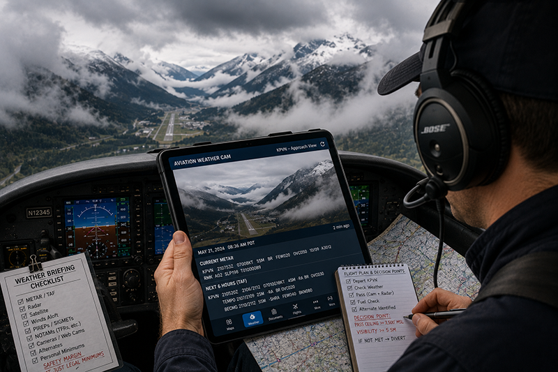
Aviation weather cameras are fixed visual observation tools positioned to show weather conditions at or near airports, passes, approaches, valleys, shorelines, and other operationally significant locations. Depending on the system and installation, a camera may show a runway environment, ramp area, nearby terrain, horizon reference, approach corridor, or a known weather choke point. Some camera systems include multiple views from the same location, such as north, south, east, and west-facing images.
The value of a camera is not that it replaces a METAR, TAF, pilot report, weather radar, surface analysis, satellite image, or standard briefing. Its value is that it adds a visual layer to those products. Text weather reports may indicate visibility, ceiling, wind, temperature, dew point, altimeter setting, and remarks. A camera may show whether the terrain is visible, whether a valley is filled with fog, whether snow is reducing surface contrast, or whether a shower is sitting directly over a planned departure path. That visual cue can make the weather situation more concrete.
For pilots operating in terrain, coastal areas, cold weather, remote regions, or locations with rapidly changing conditions, cameras may provide particularly useful context. In flat terrain, they may still help with haze, smoke, precipitation, low ceilings, runway contamination awareness, or convective buildup in the distance. The benefit depends on camera placement, visibility of known reference points, lighting, image update frequency, and the pilot's ability to interpret the image correctly.
Why This Matters in Real-World Aviation
Weather decision-making is one of the most important judgment skills in aviation. A pilot may have a legal weather minimum, a personal minimum, an aircraft performance limitation, an operational constraint, and a passenger expectation all competing for attention. Aviation weather cameras help bring the outside world into that decision before the aircraft ever moves.
Consider the difference between reading a visibility value and actually seeing a ridge disappear behind localized mist. A report may be accurate for the airport sensor location, while the camera view reveals that a nearby pass, shoreline, or valley is already deteriorating. Conversely, a camera may show that fog reported earlier has lifted from a runway environment, prompting the pilot to seek updated official weather and reassess the timing of the flight. The camera does not make the decision, but it can help a pilot ask better questions.
In training, weather cameras are useful because they teach students to connect weather products with visual reality. A flight instructor can compare a METAR ceiling with a camera image of cloud bases over terrain. A student can learn how haze differs from mist, how snow showers can reduce contrast, and why a single clear view does not prove the entire route is clear. This type of visual learning supports the development of weather judgment, which cannot be built from rote memorization alone.
For aviation professionals, cameras can support dispatch discussions, route selection, timing decisions, and risk management conversations. A camera image can help identify whether a reported condition appears widespread, localized, improving, or deteriorating. It can also help crews communicate more precisely. Instead of saying the weather looks marginal, a pilot can describe specific visual evidence: terrain obscured to the west, low cloud along the valley floor, rain shaft moving across the departure corridor, or smoke limiting visibility toward the destination.
How Pilots Should Understand Weather Camera Images
A weather camera image is a snapshot from a fixed viewpoint. That sounds simple, but it has important implications. The camera sees only what its lens, location, and lighting allow it to see. It may be aimed away from the route you intend to fly. It may be lower than the flight path, blocked by buildings or terrain, affected by condensation, or pointed into sun glare. The image may be current, or it may be delayed. The pilot must evaluate both the weather and the quality of the observation.
Start with the timestamp. A beautiful camera image is not useful if it is old and the weather is changing quickly. When viewing any camera system, confirm the time of the image and compare it with current METARs, radar, satellite, and the time of your planned operation. In fast-moving weather, even a recent image can become outdated quickly. In stable conditions, a camera series or loop may be more useful than a single frame because it can reveal trend direction.
Next, identify what the camera is actually viewing. A camera looking toward the airport traffic pattern may be very helpful for local VFR practice. A camera looking across a mountain pass may be more useful for route selection than airport surface conditions. A ramp camera may show precipitation and surface wetness, but it may not show cloud height or visibility beyond the airport boundary. A terrain-oriented camera may show obscuration but may not show runway condition. Knowing the purpose and orientation of the camera prevents overinterpretation.
Reference points matter. If you know the distance and elevation of a ridge, tower, shoreline, hangar, or mountain visible in the image, you can make a more disciplined assessment of visibility and cloud coverage. Without known references, the image is more subjective. A scene may look clear because the lens faces a bright area of sky, while clouds or precipitation may exist in another quadrant. A scene may look worse than it is because a nearby shower, dirty lens, low sun angle, or poor contrast dominates the image.
Lighting is another major factor. At night, a camera may show runway lights, ramp lights, nearby city glow, or precipitation streaks, but it may not provide a reliable sense of cloud height or terrain visibility. During sunrise or sunset, glare can wash out important details. In snow-covered environments, contrast may be low even when visibility is technically adequate. During smoke or haze events, a camera may show reduced contrast before a pilot fully appreciates the operational significance of the visibility reduction.
Integrating Cameras With METARs, TAFs, Radar, and Pilot Reports
The strongest use of aviation weather cameras comes from integration. A pilot should not ask, does the camera look good enough? A better question is, how does this image fit with the rest of the weather information?
A METAR gives an official surface observation at a specific reporting station. It may include ceiling, visibility, wind, weather, temperature, dew point, and altimeter information. A TAF provides a forecast for conditions expected at an airport during the forecast period. Radar can show precipitation location and movement. Satellite imagery can show cloud patterns and larger-scale weather evolution. Pilot reports can provide real-world observations from aircraft, including cloud tops, icing, turbulence, and visibility aloft when available. A weather camera contributes a visual surface or terrain-based view.
When these sources agree, pilot confidence in the weather picture generally improves. For example, if the METAR reports VFR conditions, the TAF suggests continued VFR, radar is quiet, satellite shows limited cloud development, and the camera shows clear terrain and good horizon definition, the pilot has a coherent picture. That does not eliminate risk, but it supports a more informed decision.
When the sources disagree, the camera becomes a prompt for deeper analysis. If the METAR reports good visibility but the camera shows a pass obscured, the pilot should consider whether localized terrain weather is present. If the camera looks acceptable but radar shows showers moving toward the route, the image may simply be behind the weather trend. If the TAF suggests deterioration later, a current camera image may not be relevant to a delayed departure. Disagreement between products is not an inconvenience. It is a warning to slow down and understand why.
Flight instructors can use this integration process as a teaching method. Instead of asking a student to decide based on one product, ask the student to build a weather narrative. What is the air mass doing? What are the winds doing? Where is the moisture? Are ceilings lifting or lowering? Does the camera confirm the trend, contradict it, or show a local exception? This habit helps pilots move beyond isolated facts and toward operational judgment.
Using Weather Cameras for VFR Decision-Making
For VFR pilots, weather cameras can be especially appealing because visual flight depends so directly on seeing and avoiding clouds, maintaining visibility, and preserving terrain clearance. A camera can show whether the visual world ahead looks inviting or threatening. But VFR decision-making requires more than deciding whether the picture looks flyable.
A good VFR camera review begins by asking whether the image supports the entire flight, not just the departure airport. A clear ramp view may not mean the route is clear. A visible horizon at the airport may not mean the valleys ahead are open. A pass camera may show one side open while conditions are building on the other side. Pilots should compare camera views along the planned route and at diversion points whenever available.
Weather cameras also help pilots evaluate personal minimums. A student pilot may have more conservative limits than a highly experienced local pilot. A flight instructor may decide that the weather is legal but not suitable for a lesson objective. A cross-country pilot may decide that the trip is possible but lacks sufficient escape options if visibility lowers. The camera image should be used to support that judgment, not to rationalize a marginal launch.
One useful technique is to look for escape routes in the image. If a camera shows low clouds pressed against terrain, reduced forward visibility, or precipitation narrowing a valley, the pilot should ask where the aircraft could safely turn around or divert. If the answer is not clear on the ground, it will not become easier in the air. Weather cameras can reveal traps before a pilot is committed to them.
Using Weather Cameras for IFR and Instrument Training Context
Instrument-rated pilots may also benefit from weather cameras, although the use case is different. A camera does not replace instrument procedures, approach minimums, alternate planning, fuel planning, or official weather information. It can, however, provide useful situational awareness about the visual environment near an airport or route segment.
For example, a camera may show whether snow showers are passing through the airport area, whether terrain is obscured near the missed approach path, whether surface visibility appears affected by fog, or whether precipitation is increasing. For training, an instructor can use camera images to discuss the difference between reported weather, forecast weather, and what a pilot may actually see at or near minimums. This is especially valuable for helping instrument students understand that legal planning and practical risk management are related but not identical.
Instrument pilots should be careful not to let a reassuring camera view reduce discipline. A camera aimed at the ramp may look clear while low clouds exist along the final approach course. A view taken between showers may not represent conditions during the actual arrival. A destination camera may look better than nearby alternate airports, or the reverse may be true. The camera is a context tool, not an approach planning tool by itself.
Common Mistakes and Misunderstandings
The most common mistake is treating a weather camera as proof that conditions are safe. A camera can be persuasive because it feels direct and visual. Pilots naturally trust what they can see. But the camera sees less than the pilot thinks it sees. It does not measure wind shear, turbulence, icing, cloud tops, pressure trends, or conditions behind the camera. It may not show the route, and it may not show rapidly approaching weather.
Another mistake is ignoring the timestamp. A pilot may load a camera page, become distracted by flight planning, fueling, passengers, or maintenance questions, and then depart based on an image that is no longer current. Camera images should be refreshed and rechecked close to the decision point, especially when conditions are marginal or changing.
Pilots also sometimes misjudge visibility from a camera image. Visibility is not simply whether the picture looks bright. It depends on contrast, reference distance, lighting, precipitation, and atmospheric obscuration. A wide-angle lens can make distances appear different from the pilot's expectation. A clean, high-resolution image may make marginal visibility look better than it would from the cockpit. A low-quality image may make acceptable conditions look worse. The camera must be interpreted, not merely viewed.
A related misunderstanding is assuming that one good view cancels out one bad view. If an airport camera looking east shows clear conditions but the west-facing camera shows lowering clouds and precipitation, the concerning view deserves attention. Weather has direction, movement, and structure. The worst relevant view may matter more than the most pleasant one, particularly if the flight path leads toward the deteriorating sector.
Some pilots use cameras only to support a decision they have already made. This is confirmation bias. If the pilot wants to go, the clear-looking image becomes evidence. If the pilot wants to cancel, the poorest-looking image becomes evidence. Better practice is to define the operational question first. What weather risk am I trying to evaluate? Is the departure corridor open? Is the pass visible? Is the destination trend improving? Are alternates realistic? The camera should answer a specific question, not serve as emotional reassurance.
Practical Example: A Marginal VFR Cross-Country
Imagine a private pilot planning a daytime VFR cross-country from a valley airport to a destination on the other side of low terrain. The forecast suggests improving conditions late in the morning, but early observations show scattered low clouds, light rain in the area, and visibility that varies by reporting station. The route includes a pass that is familiar in good weather but offers limited maneuvering room when ceilings are low.
Before departure, the pilot reviews official weather products and then opens available aviation weather cameras. The departure airport camera shows a wet ramp, good local visibility, and a ceiling that appears higher than earlier in the morning. A camera near the pass shows the lower slopes visible but the ridge top partially obscured. Another camera beyond the pass shows brighter conditions and higher cloud bases. The images are recent, but a loop shows clouds still moving through the pass area.
A less disciplined pilot might focus on the improving destination side and decide to launch immediately. A more disciplined pilot recognizes that the pass is the controlling risk. The pilot delays departure, monitors updated observations, checks for pilot reports if available, and evaluates alternates on the departure side. Thirty minutes later, the pass camera shows improved terrain visibility with more consistent cloud lifting. The pilot still sets a conservative turn-around point before reaching the pass and briefs a diversion plan.
In this example, the weather camera did not approve the flight. It helped the pilot identify the critical route segment, avoid premature commitment, and plan a safer decision point. That is effective use.
Best Practices for Pilots
Effective use of aviation weather cameras is a habit, not a single step. Pilots should build cameras into a broader weather workflow that begins with the big picture and narrows to local details. Start with forecasts, surface patterns, radar, satellite, winds, and official observations. Then use cameras to confirm or challenge the expected visual conditions at specific points.
When reviewing camera images, compare multiple locations whenever possible. A single airport view may not capture the route. A chain of cameras can show whether weather is localized, widespread, improving, or deteriorating. If a camera system provides archived images or a loop, use it to evaluate trend rather than relying on one frame.
Use known visual references. If you routinely fly in an area, learn what prominent ridges, towers, buildings, shorelines, or road intersections look like in good conditions. During training, instructors can assign students to compare camera images with sectional chart features and actual flight views. Over time, pilots develop a more accurate sense of what a camera view means operationally.
Be conservative with marginal conditions. If the camera image raises doubt, do not treat the doubt as a problem to overcome. Treat it as information. Delay, reroute, file IFR if appropriate and qualified, select a different training objective, or cancel. The safest weather decision is often made while the aircraft is still tied down.
A practical camera workflow might include these questions:
- Is the image current, and does the timestamp make sense for my planned departure or arrival?
- What direction is the camera facing, and does that view match my route or risk area?
- What known terrain or structures can I use to judge visibility and cloud bases?
- Do the camera images agree with METARs, TAFs, radar, satellite, and pilot reports?
- What would make me delay, divert, turn around, or cancel?
These questions keep the pilot focused on decision quality rather than image shopping. Image shopping is the practice of looking through multiple views until finding one that supports the desired answer. Good aeronautical decision-making does the opposite. It looks for the weak point in the plan.
Training Applications for Flight Instructors
Flight instructors can use weather cameras as a powerful teaching tool before, during, and after lessons. Before a flight, a student can be asked to brief the weather using standard products and then explain how camera images support or challenge that briefing. This encourages the student to think in terms of evidence, uncertainty, and operational impact.
During ground lessons, instructors can compare camera images from different times of day to discuss fog formation, lifting ceilings, frontal passages, convective buildup, snow showers, or smoke movement. The instructor does not need to turn the exercise into a formal meteorology lecture. The goal is to help students recognize patterns and ask better questions.
After a flight, a camera review can reinforce what the crew observed from the cockpit. Did the camera accurately represent the route? Did it hide an important hazard? Did the student overestimate or underestimate visibility from the image? This type of debrief builds practical weather literacy.
For instrument students, cameras can support discussions about approach planning, missed approach environment awareness, and the difference between reported surface weather and visual cues outside the aircraft. For commercial students, cameras can be integrated into scenario-based training involving passengers, schedules, and operational pressure. For flight review or recurrent training, camera interpretation can reveal whether a pilot is using weather tools thoughtfully or simply collecting information without analysis.
Operational Limitations Pilots Should Respect
Aviation weather cameras have limitations that deserve explicit respect. A camera may be temporarily out of service, misaligned, obstructed, dirty, snow-covered, fogged, or affected by low light. The displayed image may be delayed. The view may not represent the runway in use, the approach corridor, or the terrain along the route. It may not show conditions aloft, including turbulence, icing, convective hazards, wind shear, or cloud tops.
Cameras can also create perspective traps. A valley may look open from one end while a turn around the bend reveals lowering terrain clearance. A cloud layer may look thin from below while the route ahead contains embedded precipitation. Snow-covered terrain may look smooth and benign while visual references are poor. Smoke can gradually reduce contrast in a way that is difficult to appreciate until a pilot is airborne.
Because of these limitations, pilots should avoid making camera-based decisions in isolation. The better approach is to use cameras to improve questions and refine risk assessment. If the camera shows conditions that are worse than expected, respect that information. If it shows conditions that are better than expected, verify with other products before increasing confidence.
Frequently Asked Questions
Can aviation weather cameras replace a standard weather briefing?
No. Weather cameras should be used as a supplemental visual tool. Pilots still need a complete weather picture appropriate to the flight, including official observations, forecasts, radar or satellite information when relevant, NOTAM awareness, and route-specific planning.
Are weather camera images considered official weather observations?
A camera image is best treated as visual situational awareness unless a specific system or operator defines its official use. Pilots should avoid assuming that a camera image carries the same meaning as an official surface observation or forecast product.
How recent should a weather camera image be before I use it?
The image should be recent enough to match the pace of the weather situation. In rapidly changing conditions, even a short delay may matter. Always check the timestamp and refresh the image close to the actual decision point.
What should I look for first in a weather camera image?
Start with timestamp, camera direction, known reference points, terrain visibility, precipitation, cloud bases, lighting conditions, and whether the view is relevant to your route. Then compare the image with other weather products.
Can weather cameras help with mountain flying decisions?
Yes, where available, cameras can be useful for evaluating terrain obscuration, pass conditions, cloud movement, precipitation, and visibility trends. They should not replace mountain flying training, route planning, conservative personal minimums, or turn-around planning.
What is the biggest risk when using aviation weather cameras?
The biggest risk is false confidence. A camera may show one favorable view while the route, destination, or alternate is affected by weather the camera cannot see. Use cameras to challenge your plan, not just to confirm it.
Key Takeaways
- Aviation weather cameras are most useful when they supplement METARs, TAFs, radar, satellite imagery, pilot reports, and sound preflight planning.
- Always verify timestamp, camera orientation, lighting, reference points, and relevance to your route before drawing operational conclusions.
- The safest use of a weather camera is to identify uncertainty early, set conservative decision points, and avoid using a favorable image to justify a marginal flight.