Aviation weather information is more accessible now than ever. Pilots carry high-resolution radar, graphical forecasts, METARs, TAFs, lightning detection, satellite imagery, and pilot reports on portable devices and in-panel displays. That abundance of data improves situational awareness but also creates new failure modes when pilots misunderstand, misapply, or overtrust modern technology.
This article identifies the top mistakes pilots make using modern weather technology, explains why those errors matter to safety and decision-making, and offers practical strategies to reduce risk. Whether you are a student pilot learning to read a METAR, a flight instructor teaching operational judgment, or an experienced professional integrating ADS-B and mobile apps into complex flights, this guidance focuses on operational use and training relevance.
Understanding the Core Issue: Data vs. Judgment
Modern weather technology delivers volume, velocity, and variety of information. The core problem is not the data itself but how pilots interpret and apply it. Weather tools produce representations and models, not absolute truth. A radar echo, a color in a mosaic, or a numerical forecast value are useful inputs. They are not substitutes for pilot judgment, cross-checking, and a clear plan for how weather changes affect safety margins.
When pilots treat weather technology as a decision-maker rather than an information source, risks follow: accepting an outdated or misinterpreted display, failing to cross-check against primary products, or using an app’s graphical forecast without understanding its limitations. Understanding the limitations of each product and how they interact with human decision-making is the practical first step to safer flying.
Why This Matters in Real-World Aviation
Weather is a leading factor in aviation incidents and conservative decision-making about weather is a foundation of safe operations. Modern tools reduce uncertainty when used correctly, shortening briefing time and improving tactical awareness. However, when tools are misused they can introduce new risks: complacency, confirmation bias, and overreliance on imperfect data sources.
For flight training and recurrent proficiency, integrating modern weather technology must emphasize interpretation, validation, and conservative application. Instructors should use real-world scenarios demonstrating how technology can mislead and how cross-checks and conservative decision rules prevent locked-in commitments to unsafe flights.
How Pilots Should Understand Modern Weather Technology
Think of each weather source as a sensor with strengths and weaknesses. METARs report actual observed conditions at a station; TAFs provide a forecast for an airfield; radar shows precipitation echoes that are often correlated to intensity; satellite imagery shows cloud cover and large-scale features; lightning networks reveal convective activity; and pilot reports (PIREPs) provide timely observations from airborne aircraft. Datalink services deliver many of these to cockpit displays, sometimes fused into composite graphics.
Key concepts for operational understanding:
- Latency: Datalinked radar and reports have an age. Know the update cadence for the service you use and assume some aging between the observed picture and the actual atmosphere.
- Resolution and filtering: Some displays smooth returns, apply algorithms to remove ground clutter, or aggregate intensity on color scales. That can hide small but hazardous features like embedded convective cells.
- Product purpose: Briefing products and tactical displays differ. A forecast product is for strategic planning; radar and PIREPs support tactical avoidance. Use the right product for the phase of flight and decision you must make.
- Failure modes: Satellite and radar can miss phenomena such as icing conditions in stratiform clouds or low-level wind shear near the surface. Knowing what a tool omits is as important as what it presents.
Common Mistakes or Misunderstandings
Below are the most frequent errors pilots make when using modern weather technology, explained with operational context and consequences.
1. Overreliance on a Single Source
Dependence on one app, one radar feed, or a single PIREP creates blind spots. If that source has an outage, a display error, or misinterpretation, the pilot may lack a timely countermeasure. Cross-checking METARs, TAFs, ATIS/ASOS/AWOS, and PIREPs alongside graphical products reduces the risk of missing contradictory or clarifying information.
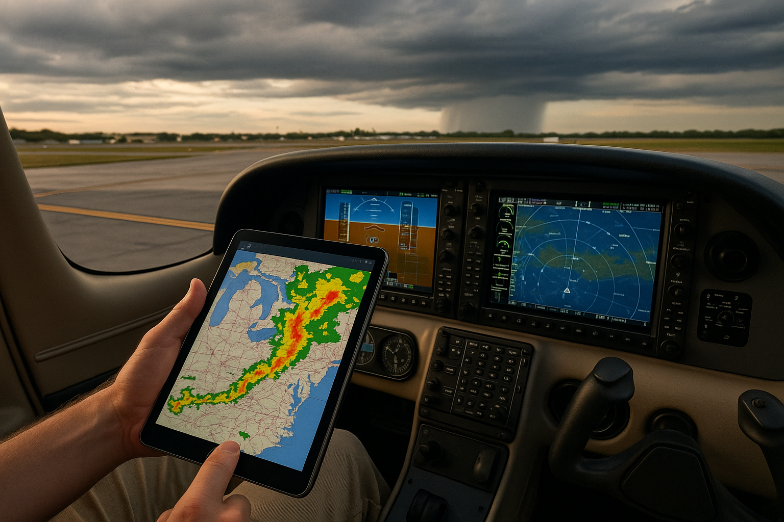
2. Misinterpreting Radar Colors or Echoes
Pilot perception often equates brighter colors with raw danger, but without context that can mislead. A broad area of light return can represent large, steady rain but is often less hazardous than a small, highly reflective core indicating heavy convective activity and potential hail. Likewise, ground clutter, sea returns, or anomalous propagation can produce spurious echoes that, if taken at face value, lead to unnecessary deviation or false reassurance.
3. Confusing Product Latency with Real-Time Conditions
Many apps and cockpit systems label the age of their weather display, but pilots do not always check or understand it. A one-minute old radar image can be useful; a fifteen-minute old aggregated mosaic in convective conditions may already be obsolete. Expect faster changes in convective weather and slower changes in stratiform precipitation. Adjust tolerance for data age accordingly.
4. Failing to Recognize Instrument and Display Limitations
ADS-B and satellite-based products provide excellent coverage but are subject to reception geometry and provider limitations. Some services derive composite mosaics from multiple radars or models that may smooth important detail. Pilots should know whether their display is showing raw returns, processed mosaics, or model-derived precipitation probability. Each requires different interpretation.
5. Treating Graphical Forecasts as Guarantees
Graphical and probabilistic forecasts are powerful but not precise. A color-coded convective outlook might show a region of enhanced risk but says nothing about timing and cell development in a small valley or coastal convergence zone. Plan using the forecast as a likelihood map, not a timetable.
6. Ignoring Local Effects and Microclimates
Modern technology often focuses on regional or national scale. Local terrain, sea breezes, and urban heat islands can produce significant departures from broader forecasts. Pilots operating in mountainous or coastal areas must blend technology with local knowledge and conservative decision-making.
7. Poor Human-Machine Interaction
Poorly configured displays, inappropriate alert settings, and token training on systems create hazards. If pilots accept default settings without understanding thresholds for alarms or color tables, they can be desensitized by nuisance alerts or miss important cues. Interacting with the tools should be part of training syllabi and recurrent checks.
8. Overconfidence in Auto-briefings and Automated Decision Tools
Automated briefings and route risk assessments are time-savers, but they can instill complacency if used without critical review. Automated tools may not account for operator-specific minima, cargo considerations, or recent local observations. Use them as a starting point and apply pilot judgment to final go/no-go decisions.
Practical Example: Cross-Country Flight into Uncertain Weather
Imagine a pilot planning a 350 NM daytime cross-country in a single-engine piston aircraft. The flight departs from a regional airport with VFR weather at departure, but forecasts show an advancing line of showers and isolated thunderstorms. The pilot uses a popular tablet app with composite radar, lightning overlay, and a route briefing that colors segments by risk.
Common mistake path: The pilot glances at the radar mosaic, sees a gap, and decides to depart. Mid-route, the pilot observes a rapid build of towering cumulus ahead on the tablet. The pilot attempts to navigate through embedded cells and accepts a tight time window to reach a fuel stop, believing the app’s composite view is current and comprehensive.
What went wrong and how to avoid it:
- The pilot relied primarily on a single composite display without checking raw radar returns, PIREPs, or ATIS updates at en route airports.
- The pilot did not consider the age of the radar image and how convective development would reduce the utility of a static composite during a dynamic environment.
- The pilot underestimated the potential for embedded convection and the difficulty of navigating VFR around rapidly evolving cells.
Better approach: Before departure, consult METARs and TAFs for en route and destination fields, recent PIREPs for convective turbulence or hail reports, and available lightning and radar products noting their age. Craft alternate plans and firm decision points: e.g., 'If the radar shows a reflectivity core within X NM of my route at the last update, divert to alternate A; if my en route observations indicate celldevelopment closer than B NM, land at the nearest suitable field.' Use conservative margins when cells are embedded or when low-level wind shear is possible near fronts.
Best Practices for Pilots
Adopt practical habits that integrate technology into a robust decision-making framework. Key practices include:
- Cross-check multiple sources. Treat graphical displays, METARs, TAFs, and PIREPs as complementary, not redundant.
- Always check product age and know typical update intervals for your data provider.
- Practice reading and interpreting raw products during training: raw radar returns, METAR remarks, and satellite imagery provide context that graphical summaries may obscure.
- Configure alerts and thresholds intentionally. Choose settings that reflect your aircraft performance, operational limits, and personal or operator minima.
- Train for human-machine interaction. Include scenario-based training where pilots must identify false echoes, interpret conflicting products, and make conservative decisions under pressure.
- Maintain a conservative margin when forecasts are uncertain or convective development is possible. Avoid narrow timelines that pressure you into marginal flights.
- Develop well-rehearsed diversion and fuel strategies. Technology should support your decision to divert early; do not let data presentations create fixation on reaching the original destination.
- Use PIREPs and communicate observations. Sharing what you see with other pilots and controllers improves the quality of real-time information available to everyone.
Training and Instructional Considerations
Flight instructors and training programs must teach weather technology as part of aeronautical decision-making, not as a separate checklist item. That means:
- Including hands-on interpretation exercises in preflight briefings and in-simulator scenarios.
- Running exercises that intentionally present conflicting or degraded data to force trainees to apply cross-checks and conservative judgment.
- Teaching the limitations of products like composite mosaics, model-derived precipitation, and derived icing indices so students understand what to expect and what to doubt.
- Reinforcing the habit of checking product age and the metadata that indicates confidence levels or coverage gaps.
Operational and Safety Implications
From airline operations to GA flight instruction, the relationship between a pilot and weather technology affects fuel planning, routing, alternate selection, and go/no-go decisions. Even well-equipped cockpits are vulnerable when crews succumb to confirmation bias or task fixation driven by attractive graphical displays. Safety management systems should monitor how technology use influences operational risk and support training that emphasizes human factors, cross-checking, and conservative contingencies.
Frequently Asked Questions
How do I know which weather product to trust?
Trust is not binary. Each product has a purpose: METARs report observed conditions, TAFs forecast expected conditions at a field, radar shows precipitation echoes, and satellite shows cloud morphology. Use the product designed for the question at hand: for whether a field is currently VFR, consult METAR and ATIS; for whether convective cells are likely to form in the next hour along your route, use radar and convective outlooks. Cross-reference products and treat disagreement as a prompt for caution.
Can I rely exclusively on tablet apps for weather briefing?
Tablet apps are valuable and often approved for briefings, but they should not replace a disciplined approach. Confirm key elements with primary sources: official METAR/TAF text, NOTAMs, and real-time reports. Be aware of app-specific processing and who supplies the data. Use apps to augment, not replace, your questioning and decision-making process.
What are signs that the weather display might be misleading?
Look for stale timestamps, unexplained gaps in coverage, sudden changes inconsistent with local reports, or small, intense cores embedded within broader, lighter returns. Also be attentive to ground clutter artifacts near terrain or coastlines and to display legends or color tables that may not match expectations. If a product lacks metadata about source and age, treat it with caution.
How should I configure alerts and thresholds for weather warnings?
Configure alerts using your aircraft performance, personal minima, and the operational environment. Avoid default settings if they produce too many nuisance alarms that could desensitize you. Instead select thresholds that will prompt meaningful action and practice responding to them in training so alerts become triggers for deliberation, not automatic reactions.
What role do PIREPs play in modern weather decision-making?
PIREPs are a high-value, direct source of airborne conditions. They are particularly useful for turbulence, icing, and cloud tops. Because they are subjective and opportunistic, PIREPs should be used as a complement to objective products. Sharing your observations contributes to the safety of others and improves local situational awareness.
Implementing a Personal Weather Standard Operating Procedure
Turn best practices into a short, repeatable routine you use every time you fly. A personal weather SOP might include steps such as: check METAR/TAF/NOTAMs for departure and destination, review radar and lightning overlays while noting image age, inspect PIREPs and recent ATIS messages, set conservative diversion decision points, and brief alternates before taxi. An SOP reduces the cognitive load and helps you resist pressure to fly on marginal information.
Key Takeaways
- Practical takeaway: Use multiple weather sources and always check product age and metadata before relying on a display.
- Safety takeaway: Overreliance on a single app or unverified graphical product can create false confidence and lead to hazardous decisions; cross-check and maintain conservative margins.
- Training takeaway: Teach and practice human-machine interaction, including recognition of display limitations and simulated degraded data scenarios.
Modern weather technology is a powerful force for safer flying when pilots understand and respect its limits. Integrate these tools into a disciplined decision-making process, invest time in reading raw products and training on system limits, and prioritize conservative planning in dynamic weather. That approach reduces surprise, increases options in flight, and keeps weather-related risk within acceptable bounds for you and your passengers.