Mountain wave turbulence is one of the most important mountain flying hazards for general aviation pilots to understand because it can affect aircraft well above ridge height, far downwind of the terrain, and sometimes in air that looks deceptively smooth from a distance. For student pilots, flight instructors, and experienced cross-country pilots alike, the danger is not simply that the ride may become uncomfortable. The deeper concern is that mountain waves can produce strong vertical air movement, severe turbulence, rotor activity, rapidly changing airspeed, and downdrafts that may exceed the climb capability of a light aircraft.
Many pilots first learn about mountain waves as a weather theory topic, often illustrated by lenticular clouds stacked like plates above a mountain range. In real flying, the subject is more practical and less tidy. A planned route over foothills, a late-afternoon return across a pass, or a VFR flight that seems comfortably clear of clouds can still place a general aviation aircraft in an environment shaped by strong wind over terrain. This article explains how mountain wave turbulence forms, what pilots should look for, how it differs from ordinary mechanical turbulence, and how to build safer aeronautical decision-making around mountain weather.
What Is Mountain Wave Turbulence?
Mountain wave turbulence is turbulence associated with atmospheric waves that form when wind flows across a mountain range or prominent ridge. When stable air is forced upward by terrain, it may continue to oscillate vertically downstream of the ridge, much like water flowing over a submerged rock. The air rises, sinks, rises again, and may form a train of waves extending downwind from the terrain. These waves can be smooth in some areas and violently turbulent in others.
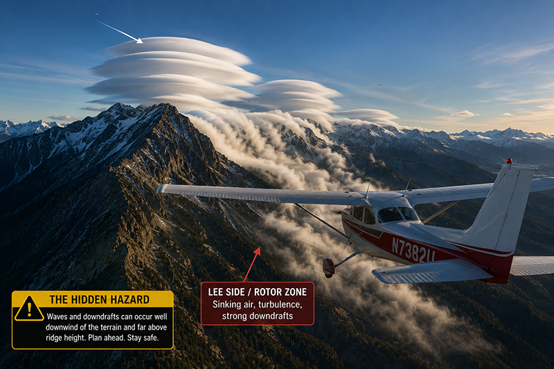
The term “mountain wave” often causes pilots to picture a single wave directly above a ridge. In practice, the pattern can include several related features. There may be rising air on the windward side, strong sinking air on the lee side, wave crests aloft, rotor circulation below the wave, and turbulence at multiple altitudes. The most hazardous parts for GA pilots are often the lee side downdrafts and rotor zones, especially when terrain clearance, aircraft performance, and pilot options are limited.
A mountain wave is not the same thing as ordinary bumps caused by rough terrain on a windy day, although both can exist together. Mechanical turbulence is caused by airflow being disrupted by surface friction, terrain, buildings, trees, and irregular ground features. Mountain waves require a broader atmospheric setup, typically involving stable air and wind crossing terrain. The resulting wave pattern can reach far above the mountaintops and can be encountered even when the aircraft is not close to the ridge visually.
For pilots, the practical meaning is straightforward: the absence of thunderstorms does not mean the air is benign. A clear, windy day near mountains may still contain significant vertical motion. A smooth ride at one altitude does not guarantee smooth air a few thousand feet lower. A route that worked well in calm wind may be inappropriate when winds aloft are strong and aligned across the terrain.
How Mountain Waves Form
Mountain waves begin with airflow over terrain. When wind encounters a mountain range, the air is lifted over the obstacle. If the atmosphere is stable, the displaced air tends to resist vertical movement and then return toward its original level. That return does not always stop neatly. The air can overshoot, descend below its equilibrium level, then rise again, creating an oscillating wave pattern downwind.
Three ingredients are commonly associated with mountain wave development: wind flowing across the ridge, atmospheric stability, and sufficient wind speed with altitude. The exact structure varies with terrain shape, wind direction, moisture, temperature profile, and the surrounding weather system. A long mountain range oriented across the wind can produce a more organized wave pattern than isolated rough terrain, but local effects can still be significant around individual peaks, passes, valleys, and escarpments.
Wind direction matters because waves are favored when the flow crosses the ridge rather than runs parallel to it. A pilot looking only at surface wind may miss the bigger picture. Winds at ridge-top level and above may be stronger or differently aligned than winds reported at an airport in a valley. This is one reason mountain flying decisions should include winds aloft, pilot reports, area forecasts, aviation weather products, and local knowledge when available.
Stability matters because unstable air tends to mix vertically and break up organized wave motion. Stable air, by contrast, can support wave formation. This does not mean stable air is automatically smooth or safe. Stable layers can allow wave energy to persist and propagate. Depending on the situation, the pilot may experience smooth but powerful updrafts and downdrafts aloft, or severe turbulence where wave energy breaks, shear develops, or rotor circulation forms below the wave.
Moisture can make mountain waves visible, but it is not required for their existence. Lenticular clouds may form near wave crests when rising air cools to saturation, while rotor clouds may appear lower and more ragged beneath the wave. However, dry air can produce strong mountain waves with few or no cloud clues. This is a critical point for VFR pilots who may associate serious weather hazards mainly with visible cloud buildup.
Recognizing Mountain Wave Clues Before Flight
Preflight weather analysis for mountain wave risk should start well before the aircraft reaches the ridge. A pilot should ask whether the planned route crosses terrain with winds strong enough and oriented favorably for wave development, whether the air mass is stable, and whether pilot reports or forecasts mention turbulence, mountain obscuration, or strong winds aloft.
Visible cloud clues can be helpful. Lenticular clouds are smooth, lens-shaped clouds that often appear stationary relative to the terrain even though air is moving through them. They may form at or near the crest of a wave. Cap clouds can form over ridge tops when moist air is lifted over terrain. Rotor clouds, when present, may appear lower, rougher, and more turbulent looking on the lee side. A line of standing lenticular clouds downwind of a range is a strong reason for a GA pilot to slow down operationally, reassess the route, and consider whether the flight should proceed at all.
Surface observations can also provide clues, but they must be interpreted carefully. Gusty surface winds near mountain airports, large differences in wind direction between valley airports and winds aloft, blowing dust, rapidly changing wind reports, or reports of low-level wind shear can all point to a disturbed flow pattern. The fact that one valley airport reports light wind does not prove the air above a nearby ridge is calm.
Pilot reports are especially valuable because they describe what aircraft actually encountered. Reports of moderate or greater turbulence, strong updrafts or downdrafts, wind shear, or wave activity near the route deserve serious attention. A report from a larger aircraft may not translate exactly to a light GA aircraft, but it still indicates that the atmosphere is active. A lack of reports should not be treated as proof of safety, especially in remote terrain or at times when few aircraft are operating.
Forecast products can help identify turbulence potential, mountain obscuration, winds aloft, and larger weather patterns. The pilot’s task is to synthesize these products into a go, no-go, or modify decision. If the route crosses a ridge nearly perpendicular to strong winds aloft, and there are lenticular clouds or recent turbulence reports, the safest answer for many GA operations may be to delay, reroute, remain on the windward side, or choose a lower-risk corridor with better terrain clearance and escape options.
What Mountain Wave Turbulence Feels Like in Flight
Mountain wave encounters can feel very different depending on where the aircraft is within the wave system. In one portion, the ride may be surprisingly smooth while the vertical speed indicator shows a strong climb or descent. In another portion, the aircraft may encounter abrupt turbulence, airspeed fluctuations, and changes in control feel. This variability is part of what makes mountain waves challenging for GA pilots.
In smooth wave lift, a pilot may notice the aircraft climbing despite level pitch and cruise power. Glider pilots intentionally use mountain wave lift under suitable conditions and with specialized training, but a powered GA pilot not expecting wave lift may be distracted by altitude deviations, airspeed changes, or proximity to controlled airspace. The more dangerous counterpart is smooth sinking air. A pilot may add power and pitch for climb while the aircraft continues to lose altitude relative to terrain. If the sinking air exceeds aircraft climb performance, the solution is not to keep pulling back. The pilot must preserve airspeed, avoid stalling, and maneuver toward an area of less sink or an escape route.
Rotor turbulence is often more abrupt. A rotor is a horizontal rolling circulation that can form beneath the mountain wave on the lee side of the ridge. It may contain strong turbulence and wind shear. Rotor zones can be particularly hazardous near terrain because the aircraft may be low, the air may be chaotic, and the pilot may have limited room to maneuver. The visual appearance of rotor clouds, when present, may be ragged or turbulent, but rotors can also occur without an obvious cloud marker.
Another important in-flight clue is the relationship between groundspeed, airspeed, and terrain. Strong wind over terrain can create unexpected drift, reduced groundspeed in one direction, increased groundspeed in another, and rapidly changing wind correction angles. A pilot who is already task-saturated by navigation, terrain clearance, and communications may be slow to recognize that wind and vertical motion are becoming the central problem.
Why This Matters in Real-World Aviation
Mountain wave turbulence matters because it changes the normal assumptions many pilots bring to cross-country flying. In flat terrain, a GA pilot may think of turbulence mainly as discomfort, convective bumps, or a passenger management issue. In mountainous terrain, turbulence can become a terrain clearance, aircraft control, and energy management issue.
The most important real-world point is that the aircraft’s ability to climb through still air does not guarantee that it can outclimb a downdraft. If a light aircraft is already near its practical performance limit due to density altitude, weight, or altitude, a strong area of sinking air can erase the expected climb margin. The correct response is to maintain safe airspeed and maneuver out of the sinking air rather than trying to force the aircraft upward with excessive pitch.
Mountain wave also affects route planning. The shortest line across a ridge may not be the safest line. A route that crosses a pass at a shallow angle, with room to turn away from rising terrain, may offer better options than a direct crossing toward higher ground. Pilots should think in terms of escape paths. If the aircraft begins to descend unexpectedly, where will you turn? If turbulence increases, can you reverse course without turning toward terrain? If the pass is not working, is there a lower-risk alternate route or a suitable airport behind you?
For flight instructors, mountain wave turbulence is a valuable teaching topic because it connects weather theory to risk management. Students may memorize definitions of lenticular clouds and rotor clouds without understanding how those features influence a go/no-go decision. Scenario-based training can help bridge that gap. Instead of asking only “What is a mountain wave?” instructors can ask, “You planned to cross this ridge today. Winds aloft are strong from the west, lenticular clouds are visible downwind, and a pilot reported turbulence along your route. What are your options before takeoff? What are your options in flight?”
For instrument pilots, mountain waves add another layer of complexity. IMC can hide terrain cues, cloud formations, and visual escape options. Turbulence, icing potential, and strong vertical currents can complicate altitude control. IFR clearance does not remove the need for terrain-aware decision-making, performance planning, and conservative weather judgment. If mountain wave conditions are possible, the pilot should evaluate whether the aircraft, equipment, route, altitude, and pilot experience are appropriate for the conditions.
How Pilots Should Understand This Topic
A practical way to understand mountain wave turbulence is to separate the wave system into zones of concern. First, there is the windward side, where air is being forced up the terrain. This area may contain upslope flow, clouds, precipitation, or turbulence depending on moisture and stability. Second, there is the ridge crest and immediate lee side, where airflow may accelerate and descend. Third, there is the wave region aloft, where smooth but strong vertical currents may exist. Fourth, there is the rotor region below the wave, where turbulence and wind shear can be significant.
This zone-based mental model helps pilots avoid a common error: assuming the hazard ends at the ridge. In some wave patterns, the most uncomfortable or hazardous area for a light aircraft may be downwind of the ridge rather than directly over it. Another error is assuming that altitude alone solves the problem. More altitude generally improves terrain clearance and buys time, but wave-related turbulence can extend well above the terrain. The safer question is not only “Am I high enough?” but also “What is the atmosphere doing, and do I have a plan if the air moves faster than my aircraft can climb?”
Pilots should also distinguish between controllable and uncontrollable variables. You cannot control the wind, stability, or terrain. You can control departure time, route, altitude selection, aircraft loading, personal minimums, and the decision to delay. You can choose to gather more weather information, call a briefer, review pilot reports, ask local instructors, or select a route that keeps you away from the lee side of high terrain during strong cross-ridge flow.
Another practical concept is energy management. In turbulence, especially near terrain, airspeed control matters. Pilots should know the aircraft manufacturer’s guidance for turbulence penetration or maneuvering speed and understand the limitations associated with operating at different weights and configurations. The exact speeds and procedures must come from the aircraft’s approved flight manual or pilot’s operating handbook. The general principle is to avoid both excessive speed in rough air and excessive pitch that risks an aerodynamic stall.
Finally, pilots should view mountain wave avoidance as a sign of skill, not timidity. The best mountain pilots are not those who press into deteriorating conditions because they have seen rough air before. They are the ones who maintain margins, recognize when the atmosphere is stronger than the aircraft, and choose options while options still exist.
Common Mistakes and Misunderstandings
One common misunderstanding is believing that mountain wave turbulence only occurs in large mountain ranges. Larger ranges can create significant wave systems, but meaningful terrain-induced turbulence can occur around ridges, foothills, escarpments, and passes when the wind and stability support it. Pilots should evaluate the actual terrain and wind relationship rather than relying on whether the area “looks mountainous enough.”
Another mistake is focusing only on surface wind at the departure or destination airport. Mountain wave is strongly influenced by wind at ridge height and above. A valley airport can be sheltered while winds aloft are much stronger. Conversely, surface gusts may alert the pilot to a broader wind problem, but they do not fully describe the vertical structure of the atmosphere.
A third mistake is treating lenticular clouds as scenic rather than operationally significant. Lenticular clouds are beautiful, and aviation photographers love them, but for pilots they are also evidence of wave activity. Their presence does not automatically mean every nearby flight is unsafe, but it does mean the pilot should conduct a more conservative weather and route analysis.
Some pilots also misunderstand downdrafts. When the aircraft begins descending in a downdraft, the instinctive response may be to add power and pitch up. Adding appropriate power may be helpful, but increasing pitch beyond a safe attitude can reduce airspeed and move the aircraft closer to a stall. If the aircraft cannot outclimb the sinking air, the priority becomes maintaining control and airspeed while turning toward lower terrain, away from the strongest sink, or toward an escape route.
Another risk is continuing into a pass or canyon with no practical turn-around option. Mountain wave, rotor, and mechanical turbulence can all become more consequential when the aircraft is boxed in by terrain. A route that leaves room to turn around before the pass is often safer than one that commits the pilot to a narrow corridor before the conditions are fully known.
Finally, pilots sometimes assume that a successful previous flight along the same route proves the route is safe today. Mountain weather is highly dependent on the current wind, temperature structure, moisture, and synoptic pattern. The same pass can be benign one morning and unsuitable for a light aircraft under different winds aloft. Experience is valuable, but only when paired with current weather analysis.
Practical Example: A Ridge Crossing Decision
Consider a private pilot planning a VFR cross-country flight in a normally aspirated single-engine airplane across a mountain ridge to reach a destination on the other side. The direct route crosses near a pass. The forecast is VFR, visibility is good, and there are no thunderstorms along the route. At first glance, the flight appears manageable.
During preflight planning, the pilot notices that winds aloft near ridge height are forecast to blow across the ridge rather than along it. The destination airport in the valley reports moderate surface wind with gusts, while the departure airport is relatively calm. A review of recent pilot reports shows turbulence in the area downwind of the ridge. Looking toward the mountains from the ramp, the pilot sees smooth, lens-shaped clouds near and downwind of the ridgeline.
The important decision is not whether the pilot is brave enough to handle bumps. The important decision is whether the aircraft and pilot have sufficient margins for the expected environment. The direct route would place the aircraft on the lee side of the ridge, approaching rising terrain with limited room to turn around. If the aircraft encounters strong sink, the pilot may not be able to maintain the desired climb gradient. If rotor turbulence is present near the pass, control workload could increase rapidly.
A conservative pilot might delay until winds weaken, choose a route that avoids the lee side of the ridge, climb to a more favorable altitude while still well away from terrain, or cancel the flight. If already airborne and conditions begin to deteriorate, the pilot should resist the temptation to press closer to the pass “just to take a look” unless there is ample room to reverse course. The earlier the decision is made, the more choices remain available.
This example illustrates the heart of mountain wave risk management. The weather may be legal for VFR, the sky may be mostly clear, and the airplane may be operating normally. Yet the combination of terrain, wind, stability, aircraft performance, and escape options can still make the flight a poor choice. Mountain flying rewards pilots who evaluate margins rather than minimums.
Best Practices for GA Pilots
The best practice for mountain wave turbulence is avoidance when conditions exceed the pilot’s experience, aircraft capability, or available margins. Avoidance does not always mean canceling every flight near mountains when the wind blows. It means making deliberate choices based on weather, terrain, altitude, aircraft performance, and personal proficiency.
Before flight, review winds aloft at altitudes relevant to the terrain, not just cruise altitude. Consider the wind direction relative to ridges and passes. Look for stability clues, cloud signatures, turbulence forecasts, and pilot reports. If available, talk with local flight instructors, experienced mountain pilots, or airport personnel who understand the area. Local knowledge should supplement, not replace, formal weather analysis.
Plan routes that preserve options. Crossing a ridge at a 45-degree angle is commonly taught in mountain flying because it can make it easier to turn away from terrain if conditions deteriorate, but pilots should receive proper mountain flying instruction before applying any technique in demanding terrain. Avoid flying up narrowing valleys or toward rising terrain without a turn-around plan. Maintain enough altitude and lateral spacing to maneuver safely.
Respect aircraft performance. Density altitude, weight, engine power, and propeller efficiency all affect climb capability. A pilot should not assume book performance will be achieved in turbulence, downdrafts, or complex terrain. Aircraft performance planning should be conservative, and the pilot should know the approved procedures and limitations for the specific airplane.
In flight, monitor the trend. A single bump is not necessarily a warning sign, but increasing turbulence, unexpected altitude loss, strong drift, lenticular or rotor cloud development, or an inability to maintain climb performance near terrain should trigger a reassessment. The safest decision is often to turn around early while the aircraft is still in open air with adequate terrain clearance.
Use short, practical habits to support good decisions:
- Check winds aloft and pilot reports before flying near significant terrain.
- Identify lee-side areas, passes, and escape routes during planning.
- Maintain safe airspeed and avoid excessive pitch if caught in sinking air.
- Turn away from deteriorating conditions before terrain limits your options.
- Seek mountain flying instruction before operating in demanding terrain or strong wind conditions.
For flight instructors, the best practice is to teach mountain wave as an operational decision-making problem, not just a weather definition. Students should learn to connect cloud clues, winds aloft, aircraft performance, and route geometry. They should also understand that legal weather minimums are not the same as safe margins in mountainous terrain.
Training Considerations for Student Pilots and Instructors
Student pilots do not need to become mountain weather specialists before solo cross-country training, but they do need a healthy respect for terrain-induced weather. Instructors should introduce mountain wave concepts in a way that is appropriate to the training environment. A student in flat coastal terrain may not face the same everyday exposure as a student based near the Rockies, Sierra Nevada, Appalachians, Cascades, or other elevated terrain, but the principles are still valuable for future flight planning.
A useful instructional approach is to begin with the visual model: wind crossing a ridge, air rising and descending, and a possible rotor below the wave. Then connect that model to cockpit indications. What would the vertical speed indicator show? What might happen to indicated airspeed if the pilot pitches up in sink? How would the aircraft’s groundspeed and drift change? What cues would prompt an early turn-around?
Scenario training is especially effective. Present the student with a planned route, winds aloft, surface observations, and cloud images. Ask whether the route should be flown, delayed, modified, or canceled. Then discuss how the decision changes with aircraft type, pilot experience, passenger pressure, daylight, fuel, and available alternate airports. This teaches that mountain wave risk is not a single number. It is a combination of factors.
Instructors should be careful not to normalize unnecessary exposure. Demonstrating light mechanical turbulence in a safe training environment is different from taking a student into hazardous mountain wave or rotor conditions. The objective is recognition and avoidance, supported by sound judgment. When advanced mountain flight training is appropriate, it should be conducted by instructors with specific mountain flying experience and careful attention to aircraft performance, weather, and escape planning.
Mountain Wave, Weather Briefings, and Aeronautical Decision-Making
Mountain wave turbulence should be integrated into the broader aeronautical decision-making process. It is not simply a weather item to check off. It affects route, altitude, timing, fuel planning, passenger comfort, aircraft performance, and emergency options.
A good preflight thought process begins with the big picture. What is driving the wind over the mountains today? Is there a strong pressure gradient, frontal system, or upper-level flow that could support stronger winds aloft? Are the winds crossing the ridges or mostly paralleling them? Are there reports of turbulence, mountain obscuration, icing, or strong surface gusts? Are lenticular or rotor clouds visible or forecast?
Next, the pilot should evaluate the aircraft and mission. A lightly loaded aircraft with strong climb performance, flown by a proficient mountain pilot in daylight with good escape routes, presents a different risk picture than a heavily loaded aircraft flown by a low-time pilot at high density altitude near sunset. The regulations may define what is legal, but judgment determines what is prudent.
Passenger pressure also deserves attention. Mountain wave turbulence can be frightening and physically uncomfortable for passengers, even when the pilot maintains control. A passenger who becomes airsick, panicked, or distracting can increase cockpit workload. Professional pilots and flight instructors should brief passengers honestly, avoid minimizing risk, and be willing to delay for comfort as well as safety.
Finally, pilots should make decisions early. Waiting until the aircraft is low, slow, close to terrain, and in turbulence is poor risk management. The best time to reject a mountain crossing is often before takeoff. The second-best time is while still far enough from terrain to turn around easily. Good mountain flying decisions are made while the pilot still has choices.
Frequently Asked Questions
Can mountain wave turbulence occur on a clear day?
Yes. Moisture can make wave activity visible through lenticular, cap, or rotor clouds, but mountain waves do not require visible clouds. Dry air can still support strong vertical motion and turbulence. Pilots should evaluate winds aloft, terrain, stability, and pilot reports rather than relying only on what they can see.
Are lenticular clouds always a no-go sign for GA pilots?
Not automatically, but they are an important warning that wave activity is present. For many GA pilots, especially those without mountain flying training or with limited aircraft performance margins, lenticular clouds near the route should prompt a conservative reassessment, possible delay, or route change.
What should I do if I encounter a downdraft near mountains?
Maintain aircraft control and safe airspeed first. Avoid the instinct to pull excessively, which can increase stall risk. Use appropriate power, follow the aircraft flight manual or pilot’s operating handbook, and maneuver toward lower terrain, away from the strongest sink, or toward a planned escape route if conditions permit.
Is mountain wave turbulence only a VFR problem?
No. IFR pilots can also encounter mountain wave, turbulence, wind shear, and strong vertical currents. Instrument flight may reduce visual terrain and cloud cues, so preflight planning, route selection, altitude awareness, aircraft capability, and conservative judgment remain essential.
How far downwind of a ridge can mountain wave effects extend?
The distance varies with wind, stability, terrain, and the larger weather pattern. Wave effects can extend well downwind of the ridge, and pilots should not assume the hazard ends immediately after crossing the terrain. Current weather information and pilot reports are important for assessing the specific day.
Should student pilots practice flying in mountain wave turbulence?
Student pilots should first learn to recognize and avoid hazardous mountain wave conditions. Any mountain flying training should be conducted with a qualified instructor, in suitable weather, in an appropriate aircraft, and with conservative margins. The goal is sound judgment, not unnecessary exposure.
Key Takeaways
- Mountain wave turbulence forms when stable air flows across terrain and creates wave-like vertical motion downwind of ridges or mountain ranges.
- For GA pilots, the greatest risks include strong downdrafts, rotor turbulence, wind shear, and reduced terrain clearance when aircraft climb performance is limited.
- Good decision-making begins before takeoff with winds aloft, pilot reports, cloud clues, route geometry, aircraft performance, and a willingness to delay or reroute.