
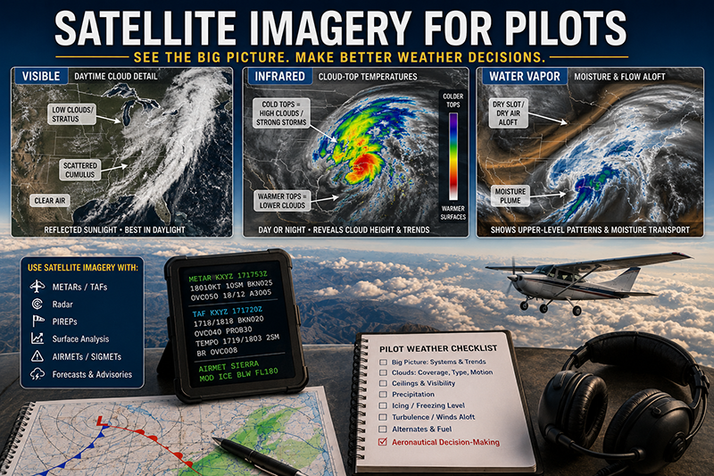
Satellite imagery for pilots is one of the most useful weather awareness tools available before a flight. A single satellite loop can show the scale, movement, and structure of weather systems in a way that a text forecast or station observation cannot. For student pilots, it helps connect classroom meteorology to what is actually happening over a route. For instructors and professional pilots, it adds context to ceilings, visibility, precipitation, convective risk, icing potential, and larger weather trends.
Visible, infrared, and water-vapor satellite views each tell a different part of the atmosphere's story. None of them should be used alone to make a go or no-go decision, and none replaces an appropriate aviation weather briefing. But when pilots understand what each image type can and cannot show, satellite imagery becomes a powerful cross-check against METARs, TAFs, radar, surface analysis, winds aloft, AIRMETs, SIGMETs, and pilot reports.
This article explains how pilots can read common satellite imagery products in practical aviation terms. The goal is not to turn every pilot into a meteorologist. The goal is to help pilots recognize useful patterns, avoid common traps, and ask better weather questions before committing an aircraft, crew, and passengers to a flight.
What Satellite Imagery Shows Pilots
Weather satellites observe the atmosphere from above and convert measured energy into images. Depending on the sensor and product, an image may show reflected sunlight, emitted heat, or moisture patterns in the middle and upper atmosphere. To a pilot, that means satellite imagery can help answer several important preflight questions: Where are the clouds? How extensive are they? Are they growing, weakening, or moving? Is there a larger system affecting the route? Are there hints of convection, widespread instrument conditions, mountain obscuration, or upper-level support for weather development?
Satellite imagery is especially valuable because it shows continuity. A METAR reports weather at a station. A TAF forecasts conditions near an airport. Radar shows precipitation or returns associated with precipitation-sized particles. Satellite imagery fills in the broad picture between reporting points and over areas where observations may be sparse. That broad view is particularly helpful during cross-country planning, night operations, mountain flying, overwater routes, and flights near developing weather.
Pilots should think of satellite imagery as a situational awareness layer. It is most useful when compared with other products. For example, a pilot might see a widespread cloud shield on infrared imagery, then confirm ceilings with METARs, look for precipitation on radar, review forecast trends in TAFs, and evaluate icing or turbulence potential using aviation weather advisories and freezing-level information. The satellite image does not make the decision by itself. It helps the pilot understand the environment in which the decision is being made.
Visible Satellite Imagery: The Pilot's Daytime Cloud Picture
Visible satellite imagery uses reflected sunlight. In simple terms, it is similar to a black-and-white or enhanced daytime photograph of the cloud field and surface features. Bright areas often indicate clouds or snow-covered ground, while darker areas may be land, water, or thinner cloud. Because visible imagery depends on sunlight, it is primarily useful during daylight hours. At night, visible imagery is not available in the same practical sense for routine pilot interpretation.
For pilots, visible satellite imagery is excellent for identifying cloud coverage, cloud texture, fog and stratus areas, boundaries between clear and cloudy air, and the growth of cumulus fields during the day. It can show whether clouds are scattered, broken, overcast, organized into bands, or building vertically. It also helps pilots see whether a route is under a continuous cloud deck or passing through areas with breaks.
Cloud texture matters. A smooth, featureless cloud shield may suggest widespread layered clouds, while a field of small cellular clouds may suggest low-level instability or cold air moving over warmer water or land. Towering cumulus and thunderstorms often appear as bright, textured, expanding features, sometimes with shadows that suggest vertical development. In late afternoon, low sun angles can make cloud shadows more apparent, which may help identify taller cloud structures. However, the same sun angle can also make interpretation more challenging if a pilot is not careful.
Visible imagery is also useful for fog and low stratus recognition, especially when compared with surface observations. A shallow fog bank may look bright and smooth, but it can be difficult to distinguish from snow cover or low cloud without additional information. The key is cross-checking. If the satellite image shows a bright, smooth area and nearby stations report low visibility and low ceilings, fog or stratus becomes more likely. If nearby stations report clear skies over snow-covered terrain, the bright area may not be cloud at all.
Infrared Satellite Imagery: Reading Cloud-Top Temperatures
Infrared satellite imagery measures emitted heat. Since all objects emit infrared energy based on temperature, infrared imagery can be displayed day or night. This makes it especially useful for preflight planning before sunrise, during night operations, or when evaluating weather trends over a long period.
The central idea is that colder cloud tops generally appear differently than warmer surfaces or lower cloud tops, depending on the color scale used by the weather provider. High clouds are usually colder because temperatures generally decrease with altitude in the troposphere. Thunderstorm anvils and deep convective clouds often have very cold tops. Lower clouds, fog, or stratus may have temperatures closer to the ground below, which can make them harder to distinguish on basic infrared imagery.
For pilots, infrared imagery is particularly helpful for identifying large cloud shields, frontal systems, tropical moisture plumes, deep convection, and nighttime cloud coverage. It can show the organization and movement of weather systems when visible imagery is unavailable. It is also useful for watching whether cloud tops are cooling or warming. Cooling tops may indicate strengthening vertical development, while warming tops may suggest weakening convection or lowering cloud depth. These are general interpretation principles, not stand-alone flight decisions.
A common misunderstanding is to assume that colder cloud tops automatically mean more hazardous weather for every aircraft. Cold tops can indicate high clouds that are not producing significant weather at the surface, or they can indicate deep convection with severe hazards. The difference depends on context. Radar, lightning information, surface observations, pilot reports, forecasts, and advisories help determine whether a cold cloud top is associated with precipitation, turbulence, icing, convective activity, or merely high-level cloudiness.
Infrared imagery also has limitations with low clouds. A low stratus deck on a cool morning may blend with the temperature of the ground or water below, especially if the temperature contrast is small. A pilot who relies only on infrared imagery may underestimate low ceilings. That is why surface observations and forecast products remain essential when ceiling and visibility are operational concerns.
Water-Vapor Imagery: Seeing Moisture and Flow Aloft
Water-vapor imagery depicts moisture patterns in portions of the middle and upper atmosphere. It does not show all atmospheric moisture from the surface to the tropopause, and it should not be read as a direct map of cloud bases, ceilings, or surface humidity. Instead, it helps pilots understand larger-scale flow, dry slots, moisture plumes, upper-level disturbances, and areas where weather systems may be supported by atmospheric dynamics.
For aviation use, water-vapor imagery is often most helpful at the big-picture stage of planning. It can show an upper-level trough approaching a region, a stream of Pacific moisture moving inland, a dry intrusion wrapping into a developing system, or the general steering flow that may influence cloud and precipitation movement. These patterns can help pilots understand why a forecast is changing, why a cloud shield is expanding, or why convection may be favored in one area more than another.
A dry slot on water-vapor imagery can be especially interesting, but it is often misunderstood. A dry-looking area aloft does not guarantee clear weather at the surface. Low clouds, fog, or precipitation may still exist beneath a dry layer. Conversely, a moist-looking plume aloft does not automatically mean poor flying conditions at the surface. Water-vapor imagery is a high-value context tool, not a ceiling and visibility product.
For instrument pilots and instructors, water-vapor imagery can be a useful way to discuss weather evolution. If a TAF suggests conditions deteriorating later in the day, water-vapor imagery may reveal the upper-level support and moisture transport behind that forecast. If radar is quiet early in the morning but the satellite loop shows a strengthening disturbance moving toward the route, a conservative pilot may watch later updates closely before launching.
Why This Matters in Real-World Aviation
Pilots do not need satellite imagery because it is visually impressive. They need it because weather decisions are rarely made from one product. A pilot may have a legal weather briefing, favorable departure conditions, and an acceptable destination forecast, yet still face changing conditions along the route. Satellite imagery helps reveal the structure and movement behind those changing conditions.
For visual flight rules pilots, satellite imagery can help identify whether a route is likely to remain visually manageable or whether cloud coverage is becoming more widespread than expected. A VFR pilot planning a long daytime cross-country can compare visible imagery with METARs along the route to see whether forecast broken clouds are actually scattered, expanding, or consolidating into a more continuous layer. This can influence route selection, timing, fuel planning, and alternate options.
For instrument pilots, satellite imagery adds context to the expected cloud environment. It may not tell the exact bases and tops for a particular route, but it can help identify whether the flight will be in a broad layered system, near convective development, under a frontal cloud shield, or approaching a dry slot. When combined with icing forecasts, freezing levels, PIREPs, and aircraft performance considerations, that context can support better risk management.
For flight instructors, satellite imagery is an effective training bridge between theory and cockpit decision-making. Students often learn about fronts, stability, moisture, lifting mechanisms, and lapse rates as separate concepts. Satellite loops show those concepts interacting in real time. An instructor can ask a student to compare the visible image with current METARs, then predict where ceilings may improve or worsen during the next few hours. That exercise builds pattern recognition and weather judgment without implying that satellite imagery is a substitute for formal weather products.
For aviation operators, satellite imagery can support operational awareness across a region. Dispatchers, chief instructors, charter operators, and maintenance repositioning planners often need to understand not just one airport but an entire operating area. Satellite loops can quickly show whether weather is local, regional, or part of a larger system that will affect multiple aircraft and airports.
How Pilots Should Understand the Three Main Views
The easiest way to remember the three common satellite views is to connect each one to the question it answers best. Visible imagery asks: What does the cloud field look like in daylight? Infrared imagery asks: How cold are the cloud tops or surfaces, and how is the cloud shield changing day or night? Water-vapor imagery asks: What is happening with moisture and flow aloft?
Visible imagery is best for daytime cloud shape and coverage. It helps with fog and stratus recognition when used with observations, and it is excellent for watching daytime cumulus development. If a pilot wants to see whether clouds are forming along terrain, lake shores, sea-breeze boundaries, or frontal zones during daylight, visible imagery is often the first place to look.
Infrared imagery is best for day-night continuity and cloud-top temperature. It is useful for identifying high cloud, deep convection, and organized weather systems. If a pilot is planning a night flight or looking at weather before sunrise, infrared imagery may provide the clearest satellite view of the cloud pattern. But the pilot must remember that low clouds can be difficult to detect when temperature contrast is weak.
Water-vapor imagery is best for upper-level pattern recognition. It helps show atmospheric flow, moisture transport, and dry intrusions. It is less useful for direct identification of low ceilings or airport weather. Pilots who use water-vapor imagery properly treat it as a planning and trend-awareness product rather than a tactical cloud-base tool.
Loops are usually more useful than single images. A still image tells where the weather appears to be at one moment. A loop shows motion, development, dissipation, and timing. Pilots should watch several frames and note whether clouds are expanding, moving faster than expected, building vertically, or clearing behind a system. Timing matters. A route that looks acceptable now may be affected by a fast-moving cloud shield before the aircraft arrives.
Interpreting Satellite Imagery With Other Aviation Weather Products
Satellite imagery becomes much more valuable when it is cross-checked with other weather products. The most useful interpretations usually come from comparing several layers rather than trying to read the satellite image in isolation.
METARs provide current airport observations. If visible imagery shows a broad cloud deck, METARs help identify ceilings, visibility, winds, and weather at reporting stations. If the image shows a break in the clouds, METARs can confirm whether conditions beneath that break are actually VFR, marginal VFR, or still restricted by haze, precipitation, or low stratus.
TAFs provide forecasts for terminal areas. Satellite imagery helps pilots judge whether the forecast trend appears consistent with the current weather evolution. If a TAF forecasts improvement after frontal passage and the satellite loop shows clearing moving steadily toward the airport, confidence may improve. If the satellite loop shows new cloud development upstream, the pilot may have reason to monitor updates closely.
Radar shows precipitation, not simply clouds. A satellite image may show extensive cloud cover without radar returns, especially with non-precipitating high or mid-level clouds. Conversely, radar may show precipitation embedded under a broad cloud shield that is not obvious from satellite imagery alone. Thunderstorm risk requires careful use of radar, convective outlooks, lightning information when available, forecasts, and official advisories, not just satellite images.
PIREPs can help connect satellite appearance to real flight conditions. A cloud shield on infrared imagery may look extensive, but pilot reports can help identify tops, icing, turbulence, and actual flight conditions. PIREPs are especially valuable in areas where automated observations do not reveal the vertical structure of clouds.
Surface analysis and prog charts add meteorological structure. Satellite imagery may show cloud bands, but surface analysis can help identify the associated front, low pressure area, trough, or boundary. That context helps pilots understand whether conditions are likely to improve, persist, or deteriorate.
Common Mistakes or Misunderstandings
One of the most common mistakes is treating a pretty satellite image as a complete weather briefing. Satellite imagery is powerful, but it does not directly provide all the information pilots need. It does not replace current observations, forecasts, NOTAM review, fuel planning, alternate planning, aircraft capability assessment, or pilot risk management.
Another mistake is assuming that clear-looking satellite imagery means safe or legal VFR conditions. Haze, smoke, shallow fog, precipitation, wind, turbulence, low-level wind shear, and nighttime terrain risk may not be obvious on a satellite image. A region can appear largely cloud-free and still present significant operational risk.
Pilots also sometimes misread high clouds as low weather. A broad cirrus shield may look impressive on infrared imagery because the tops are cold, yet the surface conditions below may be excellent. The opposite error is more dangerous for many general aviation flights: low stratus or fog may be subtle on infrared imagery and easy to miss without surface observations.
Color scales can create confusion. Different websites and applications use different enhancements. A color that indicates very cold cloud tops on one product may not mean the same thing on another. Pilots should learn the legend for the product they are using and avoid assuming that every color palette has the same meaning.
Timing errors are also common. Satellite images and loops may have update intervals, processing delays, or display settings that affect what the pilot sees. A pilot should verify the timestamp and understand whether the loop is showing the most recent data. This is especially important near rapidly developing convection, coastal fog, or fast-moving frontal weather.
A final misunderstanding is expecting satellite imagery to provide exact cloud bases or tops. Satellite images can suggest cloud type, depth, and structure, but they do not directly provide precise bases over a specific route. Pilots should use observations, forecasts, PIREPs, and other aviation weather tools to assess bases, tops, icing potential, and instrument conditions.
Practical Example: Planning a Cross-Country With Changing Clouds
Consider a private pilot planning a daytime VFR cross-country from an inland airport to a coastal destination. The departure airport reports good VFR conditions, and the destination TAF suggests marginal VFR improving later in the afternoon. The pilot opens visible satellite imagery and sees a smooth, bright cloud layer along the coast, with inland areas mostly clear. A loop shows the coastal stratus slowly retreating toward the shoreline, but not as quickly as the forecast improvement might suggest.
The pilot then compares METARs along the coast. Several stations near the shoreline still report low ceilings and reduced visibility, while inland stations remain VFR. Radar shows no precipitation. Infrared imagery from the early morning showed the cloud deck overnight, but as the sun rises, visible imagery provides a much better picture of the actual stratus edge. Water-vapor imagery shows little relevance to the low-level coastal cloud problem, but it confirms there is no obvious large-scale upper disturbance driving widespread weather over the route.
In this scenario, the satellite imagery does not tell the pilot to go or cancel. Instead, it improves the pilot's questions. Is there a reliable inland alternate? Is the route close enough to the coast that the stratus could affect terrain clearance or airspace options? How current are the destination observations? Does the pilot have an instrument rating and an aircraft equipped and suitable for IFR if conditions do not improve? Is delaying departure the simplest way to reduce risk?
A conservative decision might be to delay until the visible satellite loop and coastal METARs both show sustained improvement. Another reasonable decision might be to plan a route that remains inland with a suitable alternate, provided the pilot's qualifications, aircraft capability, fuel, daylight, and weather minimums support that plan. The important training point is that satellite imagery helps identify the real weather pattern rather than relying only on a single forecast line.
Best Practices for Pilots
The best use of satellite imagery begins before the pilot is under time pressure. Pilots should learn to compare visible, infrared, and water-vapor views on routine weather days, not only when a difficult go or no-go decision appears. Pattern recognition improves when pilots regularly connect satellite imagery to the weather they later observe from the cockpit.
Start broad, then narrow. Look at the regional satellite loop first to understand the larger pattern. Then look at the route, departure, destination, and alternates. After that, compare the satellite picture with METARs, TAFs, radar, PIREPs, winds aloft, surface analysis, and relevant advisories. This prevents tunnel vision around one airport or one favorable observation.
Use the right view for the right question. During the day, visible imagery is usually the best starting point for cloud texture and coverage. At night or before sunrise, infrared imagery is often more useful. For upper-level flow and moisture patterns, water-vapor imagery adds context but should not be treated as a surface weather map.
Watch motion, not just position. A satellite loop can reveal whether weather is moving toward the route, dissipating, expanding, or redeveloping. Pilots should think in terms of where the aircraft will be later, not only where the clouds are now.
Keep limitations in mind. Satellite imagery may not show low clouds clearly in all conditions. It may not reveal visibility restrictions such as haze or smoke with enough operational detail. It does not provide runway conditions, current winds at every airport, aircraft performance data, fuel margins, or pilot proficiency. Safe decision-making still requires a complete operational picture.
- Verify image timestamps and product legends before interpreting a satellite loop.
- Cross-check satellite imagery with current observations and forecasts along the entire route.
- Use visible imagery for daytime cloud detail, infrared imagery for day-night cloud-top trends, and water-vapor imagery for upper-level context.
- Avoid making tactical thunderstorm decisions from satellite imagery alone.
- Discuss satellite interpretation during flight training and recurrent proficiency sessions.
Using Satellite Imagery in Flight Training
Satellite imagery is an excellent training tool because it connects abstract meteorology to operational judgment. Instructors can use satellite loops during preflight briefings, ground lessons, scenario-based training, and post-flight debriefs. The exercise does not need to be complicated. A student can compare a visible image with local METARs, identify cloud coverage along a planned route, and explain whether the satellite picture supports or conflicts with the forecast.
For student pilots, this builds weather awareness beyond memorizing definitions. A student who can recognize a spreading stratus deck, a developing cumulus field, or a frontal cloud band is better prepared to understand why conditions change during a flight. The instructor can then ask practical questions: What would make this route unsuitable for VFR? Where are the alternates? What would you monitor before departure? What would cause you to turn around or land early?
For instrument students, satellite imagery can support lessons on weather systems, icing risk awareness, alternate planning, and en route decision-making. A student planning an IFR training flight through a broad cloud shield should learn to ask about freezing levels, cloud tops, embedded convection, turbulence, and escape options. Satellite imagery is not the final answer, but it can reveal whether the weather is shallow, widespread, convective, or associated with a larger system.
Recurrent training can also benefit. Experienced pilots sometimes become comfortable with familiar routes and may rely heavily on habit. Reviewing satellite imagery during recurrent instruction encourages pilots to reassess assumptions, especially in regions with coastal stratus, mountain obscuration, lake-effect cloud bands, monsoon moisture, frontal passages, or rapidly changing spring and winter weather.
Operational Cautions for Different Flight Environments
Mountain flying requires particular caution. Satellite imagery can show clouds over ridges and valleys, but it may not provide the detail needed to assess pass conditions, downdrafts, turbulence, or obscuration at a specific location. Orographic clouds can form and dissipate quickly, and terrain can limit escape options. Pilots should combine satellite imagery with local observations, forecasts, winds aloft, pilot reports, and conservative route planning.
Coastal operations also demand careful interpretation. Marine stratus and fog can move inland or retreat quickly, sometimes leaving large differences between nearby airports. Visible imagery is often valuable during daylight, but pilots should still confirm conditions with observations and be cautious about assuming that a clearing trend will continue.
Convective weather is another area where satellite imagery must be used carefully. Satellite loops can show building cumulus, overshooting tops, anvils, and expanding convective complexes, but thunderstorm avoidance requires a broader set of tools and conservative judgment. Radar, lightning information, convective forecasts, advisories, air traffic information, and onboard weather limitations all matter. Satellite imagery is strategic. It helps pilots see the pattern and trend, but it is not a close-range thunderstorm penetration tool.
Winter operations add further complexity. Infrared imagery can show cloud shields and cold tops, but it does not directly tell a pilot whether icing will occur in a specific layer. Snow cover can complicate visible imagery. Low clouds over snow-covered ground may be hard to distinguish without observations. Pilots should use icing forecasts, freezing levels, PIREPs, AIRMETs, SIGMETs when applicable, and aircraft-specific limitations and equipment considerations.
Frequently Asked Questions
Which satellite view is best for pilots?
No single view is best for every situation. Visible imagery is usually best for daytime cloud detail, infrared imagery is useful day or night for cloud-top temperature and broad cloud patterns, and water-vapor imagery is best for understanding moisture and flow aloft. Pilots get the most value by comparing the views with aviation observations and forecasts.
Can satellite imagery show cloud bases?
Satellite imagery does not directly provide precise cloud bases for a route or airport. It can suggest cloud coverage, type, and vertical development, but pilots should use METARs, TAFs, PIREPs, area forecasts and advisories when available, and other aviation weather products to evaluate ceilings and flight conditions.
Why can low clouds be hard to see on infrared imagery?
Infrared imagery is based on temperature. Low clouds may have temperatures similar to the ground or water below, especially in stable or cool conditions. When the temperature contrast is weak, low stratus or fog can be difficult to identify on basic infrared images.
Is water-vapor imagery useful for VFR pilots?
Yes, but mainly as a big-picture tool. Water-vapor imagery can help VFR pilots understand larger weather trends, such as moisture moving into a region or an upper-level disturbance approaching. It should not be used by itself to determine whether ceilings and visibility meet VFR needs.
Should pilots use satellite imagery for thunderstorm avoidance?
Satellite imagery can help identify developing convection and large-scale thunderstorm patterns, but it should not be the only tool used for thunderstorm avoidance. Pilots should use appropriate radar information, forecasts, advisories, lightning information when available, and conservative avoidance practices.
How often should pilots review satellite imagery before a flight?
Pilots should review satellite imagery during preflight planning and again close to departure when weather is changing. For longer flights, pilots should consider updated weather information en route through appropriate aviation weather resources and services available for the operation.
Key Takeaways
- Visible, infrared, and water-vapor satellite imagery answer different aviation weather questions, so pilots should use the correct view for the decision being made.
- Satellite imagery is most valuable when cross-checked with METARs, TAFs, radar, PIREPs, forecasts, and aviation weather advisories.
- Good satellite interpretation supports better judgment, but it does not replace a complete weather briefing, aircraft limitations, pilot proficiency, or conservative decision-making.