Thunderstorm risk along a route is one of the most important weather decisions a pilot can evaluate before flight. A thunderstorm is not just a rain shower with lightning. It can involve severe turbulence, strong updrafts and downdrafts, hail, icing, wind shear, microbursts, rapidly changing visibility, and convective outflow that may affect airports well away from the visible storm core.
For student pilots, flight instructors, instrument pilots, dispatchers, and aviation professionals, the question is rarely as simple as whether thunderstorms are forecast. The better question is whether the route, timing, aircraft capability, pilot experience, airspace, fuel plan, and available escape options support a safe go, delay, divert, or cancel decision. This article explains how to evaluate convective weather risk in practical flying terms, using conservative aeronautical decision-making rather than wishful interpretation of radar colors.
Start With the Nature of Convective Weather
Thunderstorms are convective weather systems, meaning they are driven by rising air. The basic ingredients include moisture, instability, and lift. Moisture supplies the fuel for cloud and precipitation development. Instability allows air parcels to continue rising once lifted. Lift may come from surface heating, fronts, terrain, sea breezes, boundaries left behind by earlier storms, or other atmospheric triggers.
For pilots, the exact meteorological mechanism matters less than the operational result: thunderstorms can grow, move, merge, weaken, and redevelop faster than a normal cross-country flight plan can adapt. A route that looked workable during preflight planning may become unacceptable by the time the aircraft reaches the critical portion of the trip. That is why thunderstorm evaluation must be continuous, beginning before engine start and continuing through taxi, departure, cruise, approach, and landing.
It is also important to separate ordinary precipitation from deep convection. A broad area of light to moderate rain may reduce visibility and ceilings, but it does not automatically imply thunderstorm hazards. A convective cell, by contrast, can produce dangerous conditions in and near the storm. The hazards may extend outside the heaviest precipitation, especially near gust fronts, anvil regions, virga, and outflow boundaries.
A good thunderstorm risk assessment does not focus only on whether the magenta or red returns are directly over the planned course. It asks whether the atmosphere is capable of producing storms, where the storms are expected, when they are expected, how they are moving, how quickly they are changing, and whether there is enough safe room to avoid them without creating a new hazard such as fuel pressure, terrain conflict, airspace complexity, or approach below personal minimums.
Build the Big Picture Before Looking at the Route Line
A common planning error is to open a radar display, draw a mental line from departure to destination, and decide whether the line appears to thread between cells. That approach skips the most important step: understanding the weather system. Thunderstorm risk evaluation should begin with the synoptic and regional picture before narrowing to airports and route segments.
Start by asking what kind of convective environment exists. Is there a cold front moving across the route? Is there a warm, moist air mass with afternoon heating? Are storms expected to form along a dryline, sea breeze, mountain ridge, or old outflow boundary? Is the route under a broad area of convective potential, or is the risk confined to a narrower corridor? These questions help the pilot determine whether a gap between storms is likely to remain open or close rapidly.
The big picture also helps with timing. Thunderstorm risk often changes dramatically during the day. In many warm-season patterns, conditions may be relatively quiet in the morning and much more active by late afternoon or evening. In other patterns, organized convective lines may move through overnight or during the early morning. A pilot who understands the expected timing can make better decisions about departing earlier, delaying until passage, selecting an alternate route, or canceling.
Regional weather products, graphical forecasts, airport forecasts, convective outlooks, and pilot weather briefings can all contribute to the big picture. The goal is not to memorize every product. The goal is to answer practical questions: What is the thunderstorm threat? Where is it moving? When will it affect my route? What is my margin if the forecast is early, late, stronger, weaker, or displaced?
Evaluate Departure, En Route, Destination, and Alternate Risk Separately
A route-based thunderstorm evaluation should not treat the trip as one continuous line. Break the flight into decision areas: departure, climb, en route cruise, descent, destination, alternate, and escape options. Each phase has different exposure and different flexibility.
Thunderstorms near the departure airport may affect surface winds, visibility, runway selection, taxi timing, and the ability to return after takeoff. Convective outflow can cause abrupt wind shifts or gusty crosswinds. A cell that is not directly over the field may still make the first few minutes of flight a poor time to be airborne, particularly for training aircraft or lower-time pilots.
The climb segment deserves special attention because aircraft performance, workload, and options may be limited. Climbing into a lowering ceiling, toward embedded precipitation, or toward a narrowing gap between cells can trap a pilot quickly. In mountainous terrain or complex airspace, the climb path may have fewer escape directions. A safe route on a map is not necessarily safe if the aircraft cannot climb, turn, or descend away from weather when needed.
En route thunderstorm evaluation focuses on movement, spacing, trends, and alternatives. Are cells isolated enough to avoid visually and strategically? Are they forming into a line? Are they embedded in widespread instrument conditions? Are tops building rapidly? Is the route dependent on a single gap? Does the flight have enough fuel and daylight to deviate substantially? If a deviation requires coordination with ATC, restricted area avoidance, terrain clearance, or a different fuel stop, that complexity belongs in the risk assessment.
The destination is where many pilots become vulnerable to plan continuation bias. After flying most of the route, it is tempting to press toward an airport even as storms build nearby. Destination thunderstorm risk should be evaluated with the same discipline as departure risk. Ask whether the approach corridor, missed approach path, runway environment, and nearby alternates are likely to remain usable at arrival time. A destination surrounded by convective cells can become a trap even if the airport itself is temporarily VFR.
Alternates and diversion airports are not just regulatory concepts. They are practical safety valves. When thunderstorms are in the area, an alternate should not be selected merely because it appears on a flight plan. It should be reachable, operationally suitable, and positioned outside the same deteriorating weather problem when possible. A nearby airport under the same convective line may not provide meaningful risk reduction.
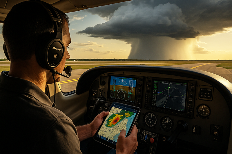
Understand What Radar Can and Cannot Tell You
Weather radar is one of the most useful tools for thunderstorm avoidance, but it is also one of the easiest tools to misinterpret. Pilots must understand latency, coverage limitations, attenuation, display smoothing, altitude differences, and the difference between strategic and tactical use.
Ground-based radar images delivered to cockpit displays, tablets, and mobile devices are not real-time views of the air immediately ahead. They are processed, transmitted, and displayed with some delay. The age shown on a cockpit or tablet display may not represent the age of every pixel in the image. In fast-developing convective weather, a few minutes can matter. For that reason, datalink radar is best used strategically: deciding where the major areas of weather are, how the system is moving, and whether the route remains viable. It should not be used to pick a tight path between cells at close range.
Airborne weather radar, where installed and properly used, can provide more immediate information ahead of the aircraft, but it also requires training. Tilt, range, beam geometry, precipitation intensity, and attenuation all affect interpretation. A weak return behind a strong cell may not mean clear air; the radar beam may be unable to see through heavy precipitation. Aircraft without onboard radar, common in training and light general aviation, must rely more heavily on strategic planning, visual avoidance when conditions allow, ATC assistance when available, and conservative decision-making.
Visual cues remain valuable, especially in VFR operations. Towering cumulus, dark bases, virga, rain shafts, lightning, shelf clouds, rapidly changing wind, and dust or debris from outflow are all signals that convective risk is present. However, visual flying around thunderstorms can be deceptive. Haze, darkness, terrain, sun angle, and embedded cells can hide the true structure of the storm. If the only plan is to see and avoid convective weather while continuing toward a destination, the margin may be thinner than it appears.
Look for Trends, Not Just Current Conditions
A safe thunderstorm decision depends more on trends than on a single snapshot. A radar image, METAR, or forecast taken alone can create false confidence. Pilots should compare several pieces of information over time and ask whether the weather is improving, deteriorating, organizing, or becoming more scattered.
For example, isolated cells that remain nearly stationary with clear air around them may be easier to avoid than a growing line of storms moving across the route. A destination METAR showing VFR conditions may be less important than a line of cells approaching the airport from the west. A route that is clear now may become unusable if convective initiation is expected along the exact corridor during the planned arrival window.
Trend evaluation also includes cloud development. Before thunderstorms appear on radar, pilots may see cumulus towers building vertically, bases lowering, or anvils spreading downwind. In warm, unstable air, small changes can become operationally significant. If cumulus is becoming more vertical and organized along the route, the pilot should treat that as meaningful information, not background scenery.
Timing is a trend question as well. A flight departing at 1000 local may have a very different risk profile than one departing at 1500. The aircraft's groundspeed matters. A slow training aircraft may spend hours in the convective environment, while a faster aircraft may cross a region before expected development. Even then, speed is not a substitute for avoidance. It simply changes the exposure calculation.
Assess the Route for Escape Options
Thunderstorm avoidance is not only about the planned course. It is about the ability to leave the planned course early. A good route gives the pilot room to maneuver, airports to use, fuel to spare, and decision points before the aircraft is boxed in.
When evaluating a route, look at the geography. Are there mountains, large bodies of water, restricted areas, congested terminal airspace, or long stretches without airports? Are there safe altitudes and terrain clearance options if a deviation is needed? Will the route require flying toward rising terrain while storms build along the ridges? Can the pilot turn around safely if the weather ahead deteriorates?
Airspace matters too. Deviating around weather in busy airspace may require early communication, ATC coordination, and patience. ATC can be an important resource, but controllers cannot make the weather decision for the pilot. Their radar weather information may be limited by equipment, workload, and display capability. A clearance through or around weather should never be interpreted as a guarantee that the path is safe.
Fuel is one of the most practical risk controls. Thunderstorm deviations can add distance, time, and workload. A pilot who launches with only narrow fuel margin may feel pressure to continue even when a conservative diversion would be safer. Building extra fuel into a convective weather plan is not just a convenience. It gives the pilot choices.
Escape planning should include preselected decision points. Rather than saying, 'we will see how it looks,' a pilot might decide before departure that if storms develop within a certain corridor, if the destination trend deteriorates, or if the route becomes dependent on a single narrow gap, the flight will land short, turn around, or wait. The exact criteria should be appropriate to the aircraft, pilot, operation, and weather picture. The key is to make the decision before pressure builds.
Why This Matters in Real-World Aviation
Thunderstorm risk evaluation matters because convective weather compresses time. In many other weather decisions, pilots have time to observe gradual changes and adjust. Thunderstorms can remove that luxury. A cell can develop, intensify, and affect an airport or route segment while a pilot is already airborne and committed to a plan.
In flight training, thunderstorms also test judgment. Student pilots often learn weather theory in a classroom, then see real convective decisions for the first time during cross-country planning. An instructor's role is to connect the textbook description of instability and lift to the practical question: should we fly this route today, and if so, when and with what escape plan?
Instrument-rated pilots face a different trap. Being legal and proficient for instrument flight does not make thunderstorm penetration acceptable. Instrument capability helps with clouds, visibility, navigation, and procedures, but it does not eliminate convective hazards. Embedded thunderstorms in instrument conditions can be especially challenging because the pilot may not be able to identify and avoid individual cells visually.
Commercial and professional operations also require disciplined weather risk management. Schedule pressure, passenger expectations, cargo commitments, and downstream repositioning can influence decisions. A professional approach separates operational pressure from meteorological reality. If the route does not provide safe avoidance and suitable options, the right answer may be to delay, reroute, or cancel.
How Pilots Should Understand Thunderstorm Risk
Pilots should think of thunderstorm risk as a combination of probability, severity, exposure, and margin. Probability asks how likely storms are along the route. Severity asks how strong the storms may be and what hazards they could produce. Exposure asks how long the aircraft will be in the threatened area and during what phase of flight. Margin asks whether the pilot has enough distance, time, fuel, altitude, and alternatives to avoid the threat.
This framework is more useful than simply asking whether the forecast includes thunderstorms. A low probability of isolated storms may still be unacceptable if the flight must cross a mountain pass with no good alternate. A higher probability may be manageable if the plan is to remain far from the convective area, depart before development, or wait until the system has passed and conditions have stabilized. Context matters.
Severity should be interpreted conservatively. Lightning, convective SIGMETs, severe thunderstorm warnings, rapidly growing tops, bowing lines, and strong outflow signatures all point toward increased risk. Even when a storm is not classified as severe, it can still be dangerous to an aircraft. Light aircraft are especially vulnerable to turbulence, wind shear, hail, and rapidly changing runway winds.
Exposure includes more than distance. A short flight that departs into a gust front may be riskier than a longer flight that remains well clear of the convective area. An approach flown toward a storm with limited alternate options may be more critical than a cruise segment with open airspace and multiple diversion fields. Pilots should identify the highest-risk phase of the trip, not just the worst-looking radar return.
Margin is where judgment becomes visible. A pilot with wide lateral separation, extra fuel, good alternates, daylight, current weather information, and a willingness to divert has more margin than a pilot relying on a narrow gap, late arrival, low fuel, and a destination under a deteriorating forecast. The weather may be the same, but the risk is not.
Common Mistakes or Misunderstandings
One common mistake is treating a thunderstorm forecast as either a yes or no answer. Forecast wording that includes thunderstorms does not automatically mean every flight is impossible, but it does mean the pilot must evaluate timing, location, intensity, and options. Conversely, the absence of thunder at the departure airport does not mean the route is safe.
Another mistake is overconfidence in radar gaps. A gap between cells may look inviting on a datalink display, but it may be closing, shifting, or already outdated. Flying between convective cells can also expose the aircraft to turbulence, outflow, and rapidly changing precipitation. Strategic avoidance is different from threading a needle.
Pilots also sometimes underestimate outflow boundaries. A thunderstorm can push cool air outward along the surface, creating gusty winds and wind shifts away from the storm core. That outflow can affect takeoff, landing, and low-altitude flight. If the wind at an airport changes quickly as a storm approaches, runway selection and crosswind judgment may need to be revisited.
Another misunderstanding is assuming that ATC will keep the aircraft out of trouble. Controllers can provide valuable help, including weather advisories, deviation approvals, and traffic coordination. However, the pilot in command remains responsible for weather decisions. ATC radar weather depictions are not a substitute for the pilot's preflight planning, onboard observations, and conservative judgment.
Plan continuation bias is especially dangerous in convective weather. After investing time, fuel, and effort into a flight, a pilot may keep adjusting the plan to preserve the destination. The safer habit is to decide early what conditions will trigger a diversion or landing short. A diversion made with fuel, daylight, and composure remaining is usually easier than one made after options have narrowed.
Practical Example: Evaluating a Summer Cross-Country
Consider a pilot planning a 240-nautical-mile VFR cross-country in a single-engine training aircraft on a warm summer day. The departure airport is clear in the morning, the destination forecast suggests a chance of afternoon thunderstorms, and the route crosses a region where scattered storms are expected to develop after midday. The aircraft is capable, the pilot is current, and the route has several airports along the way.
A weak analysis might focus only on the morning weather: clear sky, good visibility, and light winds. A better analysis asks whether the aircraft can complete the flight before convective development, whether the destination will remain usable at arrival time, and whether there are good airports to use if storms build early.
The pilot reviews the regional picture and sees that the highest thunderstorm risk is expected in the afternoon along a boundary near the destination. The pilot also notes that the return flight would occur during the period of greatest instability. That changes the decision. The outbound leg may be reasonable with an early departure and clear diversion plan, but the same-day return may be a poor idea if it places the aircraft near the boundary during peak development.
During preflight, the pilot identifies two airports before the convective area, one airport north of the route that could be used if storms form south of course, and a fuel stop that keeps reserves comfortable. The pilot also sets a decision point: if cumulus towers are building along the destination corridor before reaching the halfway point, the flight will land short and wait. If the destination begins reporting gusty winds, nearby lightning, or rapidly changing conditions, the pilot will not attempt to arrive simply because the field is still technically VFR.
In flight, the pilot monitors weather updates, talks with flight service or ATC as appropriate, and compares visual cues with the broader forecast. As the aircraft approaches the halfway point, cumulus towers are developing faster than expected near the destination. Rather than continue toward a narrowing set of options, the pilot lands at the planned intermediate airport, refuels, and waits. The flight may be delayed, but the decision preserves margin and avoids the classic trap of trying to beat a storm to the airport.
Best Practices for Pilots
Evaluating thunderstorm risk well requires a disciplined but practical process. The goal is not to create a rigid checklist that ignores context. The goal is to build habits that consistently reveal risk before the aircraft is committed.
- Start with the weather system, not the route line. Understand the regional setup, expected storm timing, and movement before deciding whether a route is workable.
- Use radar strategically. Datalink radar is valuable for big-picture avoidance, but it should not be used to make close-range tactical penetrations between convective cells.
- Plan deviations before you need them. Identify airports, fuel options, airspace issues, and terrain constraints that could affect a weather diversion.
- Protect the departure and arrival phases. Thunderstorms near airports can create rapidly changing winds, visibility, and workload at the worst possible time.
- Avoid single-gap planning. If the entire flight depends on one narrow opening between storms, the plan may not have enough margin.
- Make early decisions. Diverting, delaying, or landing short is easier before fuel, daylight, and emotional flexibility are depleted.
Instructors can strengthen this skill by making thunderstorm evaluation part of routine cross-country training. Instead of canceling every convective-weather lesson without discussion, use the weather day as a planning exercise. Ask the student to identify the convective ingredients, expected timing, safest departure window, diversion airports, and no-go triggers. That type of training builds judgment that transfers directly to real flying.
Instrument training should also emphasize that an instrument rating is not a thunderstorm penetration tool. Simulated instrument approaches and holding procedures are valuable skills, but convective avoidance requires weather interpretation, risk management, and humility. A pilot who is comfortable in clouds must still maintain a healthy respect for embedded convective weather.
Frequently Asked Questions
Can a pilot fly safely when thunderstorms are forecast along the route?
Sometimes, but only if the storms can be avoided with conservative margin and the route has realistic alternatives. The decision depends on timing, location, storm coverage, aircraft capability, pilot experience, fuel, terrain, airspace, and available diversion airports. A forecast mention of thunderstorms requires deeper analysis, not automatic confidence or automatic panic.
Is it safe to fly between two thunderstorm cells if radar shows a gap?
A gap on radar may not be safe, especially if the image is delayed, the cells are growing, or the gap is narrowing. Convective hazards can extend outside the heaviest precipitation. Pilots should avoid relying on tight gaps and should use radar primarily for strategic avoidance, particularly when using datalink weather.
What is the biggest risk near a thunderstorm if I am not inside the rain?
Hazards outside the rain can include turbulence, gust fronts, wind shear, hail, lightning, and rapidly changing surface winds. The visible rain shaft is not the full boundary of thunderstorm risk. Pilots should treat nearby convective activity as a broader hazard area, not just a colored radar return.
How should student pilots practice thunderstorm decision-making?
Student pilots should practice by planning real routes on convective weather days with an instructor, even if the flight is canceled. The exercise should include reviewing the regional weather pattern, identifying storm timing, selecting alternates, discussing go and no-go triggers, and explaining when to delay or divert.
Can ATC keep me clear of thunderstorms?
ATC can be a valuable resource, but controllers cannot assume the pilot's weather responsibility. They may help with deviations, traffic coordination, and available weather information, but the pilot must still evaluate the risk and decline any route that does not provide safe weather avoidance.
Final Thoughts for Safer Convective Weather Decisions
Thunderstorm risk along a route is not solved by one product, one radar image, or one rule of thumb. It is solved by building a conservative picture from multiple cues and continuously asking whether the plan still has enough margin. The best pilots are not those who can fly closest to convective weather. They are the pilots who recognize early when the better decision is to wait, reroute, divert, or cancel.
For Aviation Training Experts readers, the most valuable habit is to treat thunderstorm evaluation as an exercise in decision quality. A flight that is delayed because the margin disappeared is not a failure. It is a successful use of aeronautical judgment. When thunderstorms are in the conversation, the safest route is often the one that gives the pilot the most time, space, fuel, and freedom to change the plan.
Key Takeaways
- Evaluate thunderstorm risk along a route by studying the regional weather pattern, timing, storm movement, and route-specific escape options.
- Do not use datalink radar to thread tight gaps between cells. Treat it as a strategic planning tool and preserve wide avoidance margins.
- Make diversion, delay, or cancellation decisions early, before fuel, daylight, terrain, airspace, or passenger pressure reduces your options.