
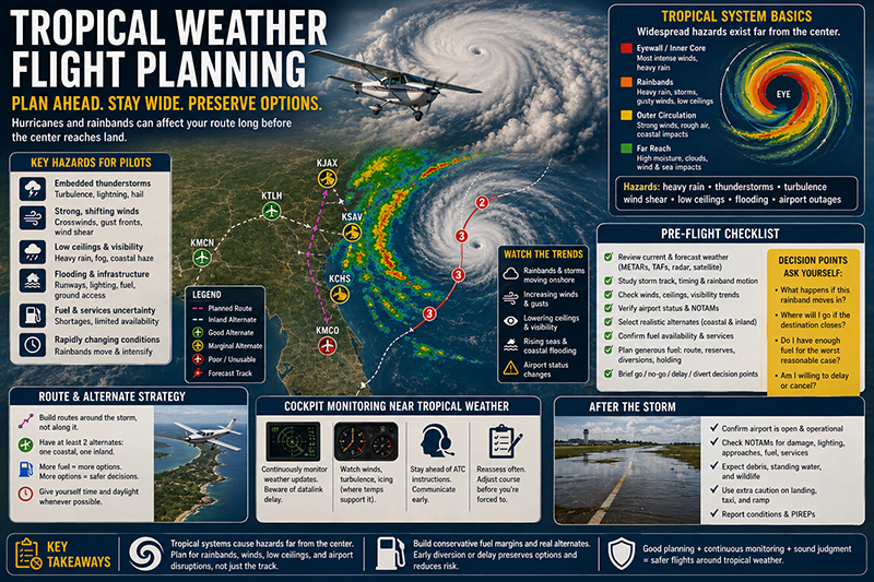
Tropical weather flight planning is a specialized form of aeronautical decision-making because hurricanes, tropical storms, rainbands, coastal wind shifts, embedded thunderstorms, low ceilings, and rapidly changing airport conditions can affect a route long before the center of a storm reaches land. For pilots, the hazard is rarely just one large weather symbol on a chart. It is the combination of moisture, wind, pressure gradients, convective activity, surface flooding, airport closures, fuel uncertainty, and narrowing diversion options.
This article is written for pilots, student pilots, instructors, dispatch-minded operators, and aviation professionals who want a practical framework for planning around tropical systems. It does not replace a current weather briefing, aircraft operating limitations, company procedures, or regulatory requirements. Instead, it explains how to think about hurricanes, rainbands, coastal routes, and diversions in a way that supports safer decisions before the engine starts.
Understanding Tropical Weather in Flight Planning
Tropical weather begins over warm ocean water and can organize into systems ranging from weak disturbances to hurricanes. From a pilot’s perspective, the important issue is not only the label attached to the system. A tropical depression, tropical storm, or hurricane can all create flight hazards depending on location, timing, aircraft capability, pilot experience, airport infrastructure, and available escape routes.
A hurricane is a mature tropical cyclone with organized circulation and very strong surface winds. The most severe conditions are usually associated with the eyewall and inner core, but aviation hazards can extend far from the center. Outer rainbands may contain heavy precipitation, thunderstorms, gusty winds, wind shear, rapidly lowering ceilings, and areas of reduced visibility. These hazards can be operationally significant even when the planned route is well away from the forecast track line.
Rainbands deserve special attention because they are often where pilots encounter the practical problems of tropical flying. A rainband may look like a line or arc of precipitation on radar, but it can contain embedded convective cells, sharp changes in wind direction, intense rainfall, and localized turbulence. In humid tropical air, visibility can fall quickly in heavy rain, and ceilings can change over short distances. A route that appears workable at departure time may become unsuitable if a band pivots, trains over the same area, or fills in along the coast.
Coastal geography adds another layer of complexity. Airports near bays, inlets, barrier islands, and low-lying terrain can be affected by flooding, salt spray, runway contamination, power outages, ground transportation problems, and fuel supply interruptions. Even after the worst weather passes, an airport may not be ready for normal operations. Pilots should treat airport availability as a dynamic operational variable, not a fixed assumption.
Why This Matters in Real-World Aviation
Tropical weather flight planning matters because these systems compress time and reduce options. A pilot may begin the day with several possible airports, acceptable weather, and adequate fuel margins. A few hours later, a rainband may sit across the destination, the preferred alternate may drop below practical use, and a coastal airport may report gusty crosswinds or deteriorating field conditions. The danger is not only the weather itself, but the way it can trap a pilot into continuing because the earlier plan seemed reasonable.
In flight training, tropical weather is a valuable topic because it forces students to connect weather theory with real dispatch judgment. A student can learn definitions of air masses, fronts, and thunderstorms in a classroom, but tropical planning asks a more operational question: where will the safe options be when the flight is actually in progress? That question is at the heart of sound pilot decision-making.
For instrument-rated pilots, tropical systems can be especially deceptive. An instrument rating improves capability in clouds and low visibility, but it does not make an aircraft immune to embedded thunderstorms, convective turbulence, icing where temperatures support it, extreme precipitation, or wind shear. IFR structure also does not guarantee that ATC will be able to provide a comfortable path around every rainband. When the airspace is saturated with deviations, reroutes, and weather avoidance requests, workload can rise quickly.
For VFR pilots, tropical moisture can turn marginal conditions into poor conditions with little warning. Coastal haze, rain shafts, low scud, and dark water backgrounds can reduce visual references. A pilot who is comfortable flying along the shoreline on a clear day may find the same route much more demanding when showers build offshore, ceilings lower, and the horizon becomes indistinct.
For operators and aircraft owners, tropical weather also affects scheduling, maintenance exposure, and asset protection. Moving an aircraft before a storm may be a prudent decision, but repositioning flights should not become rushed, poorly briefed, or pressured by the desire to save the airplane from ground damage. The safety of the flight always comes before the protection of the asset.
How Pilots Should Understand Hurricanes
A hurricane should be treated as a large, evolving weather and infrastructure event rather than a single point on a map. Forecast graphics commonly show the probable path of the center, but pilots should avoid interpreting the centerline as the boundary of risk. Weather, wind, and operational disruption can extend well away from the center, and individual rainbands can affect airports long before landfall.
The track forecast is useful, but the practical pilot question is broader: what conditions are expected along the route, at the destination, at the alternate, and at airports that might become necessary if the plan changes? A safe plan considers the entire operating area. It also considers when conditions will deteriorate and when they may realistically recover.
The timing of tropical weather is rarely as neat as a flight plan. A pilot may be tempted to depart because the destination is still reporting acceptable conditions. That report may be accurate at the moment, but it may not reflect the trend. If rainbands are moving toward the airport, if winds are forecast to increase, or if alternates are deteriorating, the current observation is only one piece of the decision.
Hurricanes also create strong pressure gradients that can generate significant winds across a broad region. At coastal airports, the resulting crosswind or tailwind component may exceed the pilot’s comfort level or the practical capability of the aircraft even when ceilings and visibility remain acceptable. Gust spread matters too. A runway that appears usable based on the steady wind may become demanding when gusts are strong, variable, or affected by nearby terrain and buildings.
After a hurricane passes, flight planning remains complicated. Airports may have standing water, damaged lighting, unavailable fuel, limited staffing, closed approach facilities, debris, damaged hangars, or restricted access. Roads to the airport may be blocked. Communications and power may be unreliable. A post-storm flight requires confirmation that the airport can actually support the operation, not just an assumption that better weather means normal service has resumed.
Rainbands, Embedded Thunderstorms, and Radar Interpretation
Rainbands are among the most common tropical weather hazards pilots must evaluate. They can be narrow and fast-moving, broad and slow-moving, or arranged in multiple arcs around the tropical system. The key planning problem is that rainbands can be convective, and convective weather requires respect even when it is not part of a classic summer thunderstorm outbreak.
Airborne weather radar, datalink radar, and ground-based radar imagery are helpful, but each has limitations. Datalink radar can be delayed, and the image a pilot sees may not represent the exact current location or intensity of cells. Airborne radar requires skill to interpret, especially in heavy precipitation where attenuation can hide stronger returns behind the first area of rain. A pilot should not use any single display as permission to continue into a region that looks convectively active.
In tropical moisture, heavy precipitation can make a cockpit workload spike. Visibility can drop, static or rain noise can increase, ATC communications may become busier, and deviations may be required. If the aircraft is near the coast, the pilot may also be balancing shoreline navigation, restricted areas, offshore airspace, traffic flows, and limited airport options.
Embedded thunderstorms are especially important because they may be hidden within broader areas of rain. From the cockpit, the pilot may not see a clear build-up or a defined cell. Instead, the aircraft may enter worsening rain and turbulence with limited visual cues. For this reason, planning should include conservative avoidance of convective areas and a willingness to delay or divert before the aircraft is boxed in.
Another subtle problem is training overconfidence. Some pilots become comfortable flying in rain and gradually normalize conditions that should prompt a more cautious decision. Light to moderate rain with stable air is one thing. Tropical rainbands with embedded convection, gusty surface winds, and moving cells are another. The distinction matters.
Coastal Diversions Require More Than an Alternate Airport
A diversion plan in tropical weather should be more than a named alternate on a flight plan. Coastal diversions require a realistic understanding of which airports will remain usable as the system evolves. A good diversion airport has suitable weather, runway length and orientation appropriate for the aircraft and pilot, available fuel if needed, functioning services, and a route to reach it without penetrating hazardous weather.
Coastal geography can make diversion planning difficult because airports may be arranged in a narrow corridor. If a rainband is aligned along the coast, several airports can deteriorate at the same time. A pilot who assumes that the next airport down the shoreline will be available may discover that the entire coastal strip is affected by the same weather feature.
In many tropical scenarios, an inland diversion may provide better options. Inland airports may be farther from the immediate marine influence, though they can still be affected by tropical rain, low ceilings, and wind. The important point is not that inland is always safer. It is that pilots should compare options by actual and forecast conditions, runway suitability, services, and route feasibility rather than by convenience alone.
Fuel planning deserves special care. Tropical weather can increase flight time through deviations, holding, reroutes, stronger-than-expected headwinds, and missed approaches. Pilots should not plan fuel so tightly that the first significant deviation creates pressure to continue. Adequate fuel supports better judgment because it preserves time, range, and choice.
Communication planning also matters. In high-weather periods, ATC workload can increase. Pilots may receive reroutes, delays, or instructions that differ from the original plan. A pilot who has already reviewed likely diversion airports, terrain, frequencies, runway options, and fuel status is better prepared to respond calmly.
Preflight Briefing Priorities for Tropical Systems
A strong tropical weather briefing starts with the big picture. Pilots should understand the system’s current position, expected movement, intensity trend, and the location of associated rainbands. The next step is to apply that picture to the specific flight: departure window, route, destination, alternates, fuel, aircraft performance, and pilot capability.
Current observations are important, but trends often matter more. Is the ceiling improving or lowering? Are winds increasing? Are showers becoming more numerous? Is the pressure falling? Are rainbands approaching from a direction that would block the planned escape route? A good briefing asks what is changing, not only what is reported right now.
Terminal forecasts can help frame expectations, but tropical convection can be localized. A forecast may communicate the broad probability and timing of weather, while the actual flight decision still requires current radar, pilot reports when available, surface observations, and updated information. If the departure time moves, the entire plan should be reviewed again. Tropical weather decisions can become stale quickly.
Notices and airport status information are also important. A runway, taxiway, lighting system, fuel provider, tower, or navigation aid may be affected by storm preparations or storm damage. Before flying to or from a coastal airport near tropical weather, pilots should confirm operational status through appropriate current channels. If the destination is uncontrolled, additional caution is needed because some problems may not be immediately obvious from a simple weather observation.
Finally, pilots should include personal minimums in the briefing. Tropical systems are not the place to stretch capability. A newly certificated private pilot, a pilot with limited instrument currency, or a pilot unfamiliar with coastal weather should use wider margins. Instructors should model this behavior by explaining not only whether a flight is legal, but whether it is wise.
Go, Delay, Divert, or Cancel: Making the Decision
The most important tropical weather decision is often made on the ground. Once airborne, choices remain, but fuel is being consumed and options may be narrowing. A disciplined pilot considers four possibilities before departure: go, delay, divert, or cancel. Treating delay and cancellation as normal aviation tools reduces the psychological pressure to launch.
A go decision should be based on a complete plan, not optimism. The route should avoid convective weather with reasonable margins, destination conditions should be suitable, alternates should be realistic, fuel should support deviations, and the pilot should be prepared for changing conditions. If the flight requires several assumptions to remain favorable, that is a warning sign.
A delay decision can be valuable when rainbands are expected to pass, when updated forecasts are needed, or when daylight conditions would improve situational awareness. However, delay is not always safer. Waiting can allow a tropical system to move closer, winds to increase, or airport services to shut down. The key is to delay for a reason, then rebrief the entire flight.
A diversion decision should be made early enough that it remains routine. In tropical weather, the best diversion may be one made before conditions become urgent. Pilots sometimes wait until the destination is clearly unsuitable, then discover that fuel, weather, and workload have all become worse. A better standard is to divert when the trend shows that the original plan is becoming less reliable.
Cancellation is a professional decision, not a failure. Airlines, corporate flight departments, flight schools, and experienced individual pilots all cancel when risk is not acceptable. For training flights, cancellation can be turned into a learning event by reviewing the weather picture and discussing what would have made the flight acceptable.
Common Mistakes and Misunderstandings
One common mistake is focusing too heavily on the hurricane track line. The track line is not a safe-route boundary. Rainbands, strong winds, low ceilings, and airport disruptions can occur away from the center. Pilots should evaluate the full weather field and operational environment.
Another mistake is assuming that IFR equals safe passage. IFR procedures help pilots operate in instrument meteorological conditions, but they are not a solution for convective weather. A light aircraft, a training aircraft, or even a capable traveling aircraft should not be used to test the edges of tropical convection.
A third misunderstanding is treating coastal airports as interchangeable. Runway orientation, field elevation, drainage, services, lighting, instrument approaches, surrounding terrain, and exposure to wind or flooding can vary widely. The nearest airport is not always the best diversion airport.
Fuel optimism is another risk. Pilots may plan legal or customary fuel reserves without fully considering tropical deviations, holding, reroutes, or a missed approach followed by a diversion. The practical question is not merely whether the fuel plan satisfies a baseline requirement. The practical question is whether it preserves safe choices if the weather behaves differently than expected.
Some pilots also underestimate the post-storm environment. Blue sky after a hurricane does not guarantee a usable airport. Debris, water, damaged lighting, unavailable fuel, or closed facilities may remain. A post-storm flight can be just as operationally complex as a pre-storm repositioning flight.
Finally, there is the pressure trap. Owners may feel pressure to move an aircraft out of danger. Students may feel pressure to complete a lesson. Business travelers may feel pressure to maintain a schedule. Tropical weather punishes schedule-driven decisions. The safest pilots recognize pressure early and deliberately remove it from the decision.
Practical Example: A Coastal Cross-Country With Rainbands
Consider a pilot planning a late-morning cross-country from a coastal airport in the Southeast to another airport 220 nautical miles up the shoreline. A tropical storm is offshore and forecast to move generally northward. The destination is outside the forecast center track, and the morning observation shows acceptable visibility and ceilings. At first glance, the flight appears possible.
A more complete review changes the picture. Radar shows several outer rainbands moving onshore between the departure airport and destination. Surface observations along the coast show gusty winds and rapidly changing visibility in showers. The preferred fuel stop is reporting increasing crosswinds, and two nearby coastal airports have limited services because operators are preparing for the storm. An inland airport 60 miles west of the route has better conditions and fuel available, but reaching it would require an early decision before the aircraft passes a gap between rainbands.
In this scenario, a safe plan might be to delay until the rainband pattern becomes clearer, choose a more inland route, or cancel the flight if the system is expected to worsen. If the pilot elects to depart, the inland diversion should be briefed before takeoff, fuel should be generous, and a firm decision point should be established. For example, if the next rainband blocks the coastal corridor or destination weather trends downward, the pilot diverts inland immediately rather than continuing to see if conditions improve.
The lesson is not that every tropical system makes flight impossible. The lesson is that tropical weather requires planning around changing options. The pilot who identifies decision points early is much less likely to be forced into a poor choice later.
Best Practices for Pilots
Effective tropical weather planning combines weather analysis, aircraft knowledge, and disciplined decision-making. The best pilots are not trying to prove that a flight can be completed. They are trying to determine whether the flight can be completed with suitable margins and reliable alternatives.
Start with a broad weather picture, then narrow it to your route. Look at the tropical system’s movement, rainband structure, surface winds, ceilings, visibility, convective potential, and airport status. Pay attention to trends and timing. A flight that is acceptable at 0900 may not be acceptable at 1200.
Build a diversion plan that you would actually be willing to use. Review the airports, runways, approaches if applicable, fuel availability, weather trends, and route to each diversion. If a diversion airport depends on flying through the same rainband that threatens the destination, it is not a strong option.
Use conservative personal minimums. Tropical weather adds uncertainty, and uncertainty should be answered with wider margins. This may include higher ceilings, better visibility, lower crosswind limits, more fuel, daylight preference, or a stricter limit on convective activity.
Brief passengers honestly. If a tropical system is nearby, explain that delay or diversion is possible. This reduces pressure in flight and helps passengers understand that changing the plan is a normal safety decision.
For instructors, use tropical weather days as teaching opportunities even when the airplane stays parked. Have the student build a route, identify rainbands, select alternates, compare coastal and inland options, and decide where the plan fails. This type of scenario builds judgment that cannot be learned from definitions alone.
- Plan around weather trends, not only current observations.
- Keep fuel margins large enough to support deviations, holding, and early diversion.
- Do not use datalink radar or a single weather product as the sole basis for convective avoidance.
- Confirm airport and service availability before relying on a coastal destination or alternate.
- Make delay, diversion, and cancellation normal parts of the plan.
Training Value for Student Pilots and Instructors
Tropical weather offers rich training value because it connects meteorology, navigation, risk management, and human factors. A student pilot can learn why a technically legal flight may still be a poor decision. An instrument student can learn the difference between flying in clouds and avoiding convection. A commercial student can practice thinking like an operator, balancing customer expectations with safety margins.
Instructors should be careful not to turn tropical weather into a fear-based lesson. The goal is not to suggest that all coastal flying is unsafe. The goal is to show how rapidly changing weather reduces options and how professional planning restores control. When students see an instructor cancel or delay for sound reasons, they learn that judgment is an active skill.
Scenario-based training is particularly useful. Ask the student to plan a coastal route with a tropical storm offshore. Then introduce updates: a rainband moves inland, the destination ceiling drops, the alternate reports gusty crosswinds, and fuel at one airport becomes unavailable. The exercise teaches students to revise the plan as conditions change rather than clinging to the original idea.
For instrument training, emphasize workload. A pilot flying an approach in heavy rain near a tropical system may face turbulence, wind changes, high radio traffic, and rapid missed approach decisions. The safest solution may be to avoid being there in the first place. That is a powerful lesson for pilots who are learning to respect the limits of ratings, avionics, and procedures.
Operational Considerations for Coastal Airports
Coastal airports can be excellent gateways for travel, training, and business, but tropical systems can affect them in ways that are not always obvious from the cockpit. Low-lying ramps may collect water. Tie-down areas may be unavailable. Fuel trucks may be moved or secured. Staff may be reduced as the storm approaches. Hangar space may be full. Even if the runway is technically open, the airport may not be able to support a normal arrival.
Wind direction is another practical issue. Tropical systems can produce changing wind directions as the circulation moves. A runway that favors the morning wind may become less favorable later. Gusty crosswinds can make landing and taxiing more challenging, especially for lighter aircraft. Pilots should consider their own proficiency and the aircraft’s demonstrated or published limitations where applicable.
Standing water and runway contamination require caution. Hydroplaning risk, braking effectiveness, and directional control can be affected by water depth, tire condition, speed, and runway surface. Pilots should avoid casual assumptions about runway performance in heavy rain. If performance information is limited or conditions are uncertain, a conservative decision is appropriate.
Night operations near tropical weather deserve added caution. Rain shafts, low clouds, black-hole effects over water, glare, and reduced visual references can make coastal flying more demanding. If the pilot is already managing weather deviations and changing airport options, darkness can increase workload significantly.
Frequently Asked Questions
Can small aircraft fly near a tropical storm if they avoid the center?
Avoiding the center is not enough. The outer rainbands, embedded thunderstorms, gusty winds, low ceilings, and airport disruptions can create serious hazards far from the center. A safe decision depends on the actual route, weather trends, aircraft capability, pilot proficiency, fuel, and diversion options.
Are rainbands always thunderstorms?
No. Some rainbands may contain mostly rain and lower ceilings, while others include embedded convective cells. The challenge is that embedded thunderstorms can be difficult to see visually and may be hidden within broader precipitation. Pilots should treat convective rainbands with caution and avoid relying on appearance alone.
Is an IFR flight plan enough protection in tropical weather?
No. IFR helps with navigation and separation in instrument conditions, but it does not remove the hazards of convection, severe turbulence, heavy precipitation, wind shear, or unsuitable airport conditions. Tropical weather planning should include weather avoidance, fuel margins, and realistic alternates.
When should a pilot divert during tropical weather?
A pilot should divert early when the original plan is becoming less reliable, not only when it has already failed. Examples include deteriorating destination weather, rainbands blocking the route, increasing fuel concern, stronger winds than expected, or an alternate becoming less suitable.
What makes a good coastal alternate during hurricane season?
A good alternate is not just nearby. It should have suitable weather, runway orientation and length appropriate for the aircraft, usable approaches if needed, available fuel and services, and a route that does not require penetrating hazardous weather. In some cases, an inland airport may be a better choice.
Should pilots reposition aircraft before a hurricane?
Repositioning may be prudent in some situations, but it should be planned like any other flight and never rushed by schedule pressure. The flight must be safe for the pilot, aircraft, and conditions. If the weather has already deteriorated or options are limited, ground protection may be the safer choice.
Key Takeaways
- Tropical weather flight planning should evaluate the entire weather environment, including rainbands, winds, ceilings, airport status, and diversion routes, not just the forecast storm track.
- Coastal diversions require realistic airport choices, generous fuel margins, and early decision points because multiple airports can deteriorate at the same time.
- For training and real-world operations, the safest decision may be to delay, divert, or cancel before tropical weather removes the pilot’s best options.