VFR navigation is at the heart of safe, efficient visual flying. Whether you are a student learning pilotage and dead reckoning, a certificated pilot integrating GPS and moving-map displays, or an instructor teaching cross-country decision making, the core task is the same: maintain position awareness, manage workload, and make timely decisions that preserve safety.
This article explains practical best practices for VFR navigation in modern aviation. It focuses on operational techniques, risk management, training priorities, and equipment use that help pilots fly accurately under visual flight rules. Read on for practical examples, common mistakes, a realistic scenario, and clear actions you can apply on your next flight.
Core concepts of modern VFR navigation
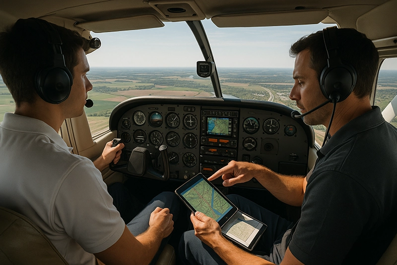
VFR navigation blends three traditional methods with modern avionics: pilotage, dead reckoning, and electronic navigation. Pilotage uses visible landmarks and chart features. Dead reckoning is position estimation based on heading, groundspeed, time, and wind. Electronic navigation includes GPS, WAAS, moving-map displays, and ADS-B traffic and weather. Effective VFR navigation uses these methods together rather than relying on any single source.
Situational awareness is the unifying skill. It includes knowing where you are now, where you will be, how weather and airspace affect your route, and what options you have if something changes. Good navigation practice reduces surprises by building and maintaining that awareness continuously.
Why VFR navigation matters in real-world aviation
Navigation errors create safety risks even in visual conditions. Common outcomes of poor navigation include controlled flight into terrain, inadvertent airspace violations, fuel mismanagement, and loss of positional awareness in deteriorating weather. For training and operations, clear navigation processes improve workload distribution, enable better decision making, and reduce the likelihood of rushed or improvised responses when things change.
For flight instructors, teaching VFR navigation means more than showing how a GPS works. It means building mental models, cross-check habits, and contingency planning. For operations and professional pilots, standardized procedures and clear cockpit flows create predictable outcomes that reduce human error and support crew coordination.
How pilots should understand VFR navigation in practical terms
Think of navigation as a continuous loop: plan, navigate, monitor, and revise. Planning sets realistic routes, fuel margins, and contingency points. Navigation is the outbound execution using heading, timing, and fixes. Monitoring checks that your progress matches expectations using landmarks, time checks, and electronic position updates. Revision is the decision to alter route, altitude, or landing plan when conditions, airspace, or system performance changes.
Integrate primary and secondary sources. For example, use GPS as your primary en route reference but confirm fixes with visual checkpoints and time/distance calculations. If a moving-map shows your position relative to a road or river, verify that feature visually and with a time check. If visibility prevents reliable visual confirmation, reduce reliance on pilotage and increase instrument-style cross-checking with electronic sources.
Human factors and workload management
Navigation accuracy is shaped by human factors. High workload moments include takeoff, departure through the traffic pattern, airspace transitions, and approach into a busy airport. Before these moments, reduce nonessential tasks, brief the next segment, and set navigation tools to give you the clearest possible information. Use simple, repeatable cockpit flows: brief, set, cross-check, and announce. That structure helps both single-pilot and multi-pilot operations.
Develop the habit of verbalizing key items: intentions, headings, leg times, and critical altitudes. In training flights, instructors should require students to speak these items aloud. Verbalization forces a cognitive check that often catches planning or execution errors before they become problems.
Common mistakes and misunderstandings
Poor VFR navigation usually comes from predictable gaps rather than random events. Below are common errors that reduce safety and efficiency:
- Overreliance on a single navigation source. Treat GPS, moving maps, and traffic displays as tools, not guarantees. Electronics can fail, display outdated charts, or offer misleading symbology under certain settings.
- Inadequate cross-checking. Failing to confirm GPS fixes with pilotage or time/distance calculations increases the risk of position error, especially in areas with similar-looking terrain.
- Poor wind estimation and groundspeed planning. Misjudging wind effects leads to drift and missed checkpoints. Pilots who skip a simple wind check and time/distance recalculation will often be off course sooner than they expect.
- Weak contingency planning. Not identifying alternates, vectors, or decision points leaves pilots scrambling if weather or traffic forces a change.
- Airspace assumptions. Assuming you are clear of controlled or special-use airspace without verifying position and altitude is a common cause of violations.
- Ignoring terrain and obstruction risks. Flying low to maintain visual contact with landmarks without assessing terrain or obstacle clearance is hazardous, particularly at night or in reduced visibility.
Addressing these mistakes requires disciplined habits: redundant cross-checks, conservative margins, and honest assessment of personal and equipment limitations.
Practical example: cross-country with mixed navigation methods
Scenario: You are flying a light single from a coastal airport to an inland field about 150 nautical miles away. Forecast shows scattered clouds and moderate winds aloft. Your aircraft has a GPS navigator with moving-map, a backup handheld GPS, and a sectional chart on a kneeboard.
Before departure, brief your route in three segments: departure and climb to your planned cruise altitude, the en route portion across a sparsely populated area, and the descent and approach into the destination traffic pattern. Identify at least two reliable checkpoints per leg that are distinct on both the moving map and the sectional chart. Estimate wind for each leg by comparing forecast winds aloft to surface winds and calculating expected groundspeed and leg time.
During the flight, use the moving-map as your primary situational tool for track and distance, but cross-check every checkpoint visually when possible. If the moving map indicates you are near a river bend, confirm by sight and by elapsed time from your last checkpoint. If your visual checkpoint is not visible due to haze, use time/distance and GPS cross-bearing from a known VOR or use the backup handheld position readout.
Halfway through, you encounter a band of buildups and turbulence. Reassess: can you maintain VFR cloud clearance and visibility to continue? If not, plan a diversion to the nearest suitable airport. Announce intentions on the radio, configure for a lower altitude if needed for smooth air, and brief the approach early. If you commit to a diversion, reprogram the GPS with the new destination, mark new checkpoints on the chart, and recalculate your fuel remaining against the new routing.
Best practices for pilots
The following practices are practical, repeatable, and applicable across single-pilot and multi-crew operations. They focus on predictability and early detection of deviations.
- Plan with conservatism. Leave fuel and time margins that allow for diversions and delays. Identify en route alternates and fuel reserves before leaving on a cross-country.
- Brief in small segments. Divide a cross-country into manageable legs and brief the next leg while flying the current one. Keep each brief focused: heading, checkpoint, time, and contingency.
- Use redundant navigation sources. Cross-check GPS with pilotage, time/distance, and if available, a certified electronic bearing or VOR where practical. Bring a backup handheld GPS and ensure it is charged.
- Establish a reliable cockpit flow. Set up radios and navigation displays before taxi when possible. Use standard flows for pre-takeoff, climb, cruise checks, and descent preparation to reduce discretionary workload during critical phases.
- Perform routine time checks. Simple time/distance checks are a robust defense against position error. When over a checkpoint, note the time on your kneeboard and use it to compare expected versus actual progress.
- Practice wind assessment. Learn quick techniques to estimate wind aloft using pilot reports, winds aloft forecasts, and real-world groundspeed checks. Recompute groundspeed and ETA when wind differs from forecast.
- Plan for degraded visual environments. If visibility looks marginal, have predefined decision points to divert or return. Avoid pressing on with marginal VFR hoping for brief improvements.
- Train for partial panel and equipment failure. Regularly practice navigating without primary electronic aids. Simulated failures force development of dead reckoning and pilotage skills that are invaluable when technology is unavailable.
- Maintain chart currency. Ensure your sectional and terminal area charts are current. Check NOTAMs and any revisions that affect your route or destination prior to departure.
Technology integration: use but verify
Modern avionics make VFR navigation easier but introduce new failure modes. Moving maps simplify situational awareness and distance-to-destination readouts, but they can present position errors due to GPS interference or improper device settings. Understand how your avionics determine position, how often they refresh, and whether they present predicted versus actual ground track. Program waypoints with descriptive names and test the device’s flight plan entry on the ground before takeoff.
ADS-B traffic and weather provide valuable information, but they are not substitutes for visual scanning and weather assessment. Treat traffic targets as advisory. Confirm weather trends with official sources when possible and use onboard displays to refine your decision making, not replace it.
Training priorities for instructors
Flight instructors should aim to create pilots who can navigate effectively without a single point of failure. Key training elements include:
- Regular practice of pilotage and dead reckoning alongside GPS navigation.
- Scenario-based training that includes diversions, equipment failures, and weather changes.
- Structured cockpit flows and verbalization of navigation decisions.
- Evaluation of students on decision making and contingency planning, not just waypoint tracking.
Encourage students to fly conservatively and to treat technology as an aid rather than a crutch. Use debriefs to analyze navigation errors, decision points, and how cross-checks could have prevented problems.
Common navigation tools and how to use them
Sectional charts, pilotage, and time/distance calculations remain foundational. Portable GPS units and panel-mounted navigators add precision. Here is how to use common tools effectively:
- Sectional charts. Use them to identify landmarks, airspace, obstacles, and airport information. Mark checkpoints and alternates before flight.
- Moving-map GPS. Use it for track guidance, distance, and estimated time en route. Confirm map orientation and set a sensible map range so your display shows useful context without clutter.
- Backup handheld GPS. Keep it powered and preloaded with your route. Put it away as a last resort if panel instruments fail, or use it to cross-check when the panel shows unexpected data.
- Radio navigation aids. Use VORs for cross-bearing fixes or long-distance position checks when available. Listen to identifiers and confirm reception.
- Kneeboard and stopwatch. The simplest tools are often the most reliable. Mark times and distances for each leg and update them en route.
When to divert: decision triggers
Deciding to divert is often a matter of predefined triggers rather than ad hoc judgment. Consider diverting when any of the following conditions arise:
- Visibility or ceiling deteriorates below the minimums you set for the flight.
- You cannot positively identify the next checkpoint visually or by cross-check within the expected time window.
- Unexpected airspace restrictions or traffic make continuing unsafe or illegal.
- Fuel state, performance concerns, or an equipment failure reduces your ability to reach the planned destination with required reserves.
Decisions made early preserve safety margins. Practice executing diversions smoothly: brief, reprogram navigation, update your ETA, and communicate on the radio.
Frequently Asked Questions
How should I pick checkpoints for pilotage?
Choose features that are distinct, persistent, and unambiguous. Rivers, major highway interchanges, large lakes, and airport complexes are good examples. Avoid similar-looking fields or roads in areas with repetitive terrain. Pick checkpoints that are visible from your planned altitude and that appear on your sectional chart and moving map.
What is the best way to estimate wind for a VFR cross-country?
Start with winds aloft forecasts and surface observations. Compare expected groundspeed with true airspeed on an initial leg to estimate actual wind. Perform a heading/groundspeed check by flying a known heading to a reliable checkpoint and comparing elapsed time against distance. Use those results to update your leg planning and ETA calculations.
Can I rely solely on my moving-map GPS for VFR navigation?
No. While moving-map GPS is an excellent situational tool, you should always verify position with pilotage or time/distance checks and maintain a basic dead reckoning capability. Electronic devices can fail, present position errors, or be misprogrammed, so redundancy is essential.
How often should I practice dead reckoning and pilotage?
Regularly. Incorporate at least one dual or solo flight per month where you deliberately navigate with limited electronics. Simulated failures during cross-country training force development of map reading, timing, and wind estimation skills that will be valuable during an actual equipment failure.
What should I do if I suspect I am in the wrong place?
First slow down workload by stabilizing the aircraft and communicating intentions if required. Stop pressuring yourself to find a specific landmark. Use a safe altitude, verify your position with multiple sources, and, if needed, divert to the nearest suitable airport while you sort the navigation issue. Announce your intentions to ATC or on the common traffic advisory frequency when appropriate.
Key Takeaways
- Practical takeaway: Use a predictable navigation flow that combines GPS, pilotage, and time/distance checks to maintain continuous situational awareness.
- Safety takeaway: Build conservatism into planning and establish early decision points to divert before safety margins collapse.
- Training takeaway: Practice navigation without primary electronics and incorporate scenario-based diversions and failures into regular training.
VFR navigation remains a core pilot skill even as technology evolves. The safest pilots are those who integrate modern tools thoughtfully, maintain pilotage and dead reckoning skills, and apply disciplined decision-making under pressure. Use the practices described here to structure your planning, cross-checking, and in-flight monitoring so every flight is predictable, manageable, and safe.