
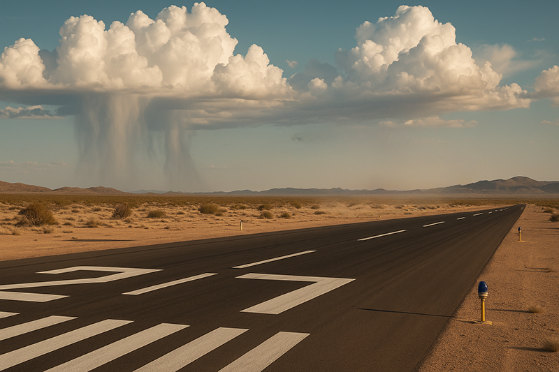
Virga and evaporative cooling are two weather concepts every pilot should understand before flying near showers, towering cumulus, or high-based thunderstorms. Virga is precipitation that falls from a cloud but evaporates before reaching the surface. To a pilot, it often appears as gray, wispy streaks hanging below a cloud base, sometimes with a blurred or ragged lower edge that never connects with the ground. That visual clue matters because the same evaporation process can cool the air, increase its density, and contribute to descending air that may become a downdraft, gust front, or in more intense cases, a microburst.
For student pilots, instructors, dispatchers, and experienced aviators, virga is more than an interesting cloud feature. It can be an early warning sign that the atmosphere is producing localized wind shear, turbulence, and rapidly changing surface winds. The hazard is especially important in dry environments, during summer convective weather, and beneath high cloud bases where rain can evaporate into relatively dry air. This article explains what virga looks like, why evaporative cooling can accelerate downdrafts, how those downdrafts relate to microbursts, and how pilots can use visual clues as part of a disciplined weather decision-making process.
What Virga Is and Why It Forms
Virga forms when precipitation begins falling from a cloud but encounters a layer of air below the cloud that is dry enough for the precipitation to evaporate before it reaches the ground. The precipitation may start as rain, snow, or ice particles depending on cloud temperature and altitude, but the important point for pilots is that falling hydrometeors are entering unsaturated air. As they evaporate or sublimate, the air below the cloud changes physically.
Evaporation requires energy. When liquid water evaporates into vapor, it draws heat from the surrounding air. This process is evaporative cooling. The cooled air becomes denser than the surrounding warmer air. Dense air tends to sink. If the cooling is strong enough and concentrated enough, the descending motion can become a downdraft. If that downdraft reaches the surface and spreads outward, a pilot may encounter sharp changes in wind direction and speed, turbulence, and performance-robbing sinking air.
Not every patch of virga means a dangerous microburst is present. Some virga is weak and occurs in relatively benign weather. However, pilots should avoid treating virga as harmless simply because rain is not reaching the airport or the surface observation does not show active precipitation. The evaporation itself can be part of the hazard. In dry air, the absence of rain at the ground can actually be one reason the air below the cloud cools effectively and descends.
Virga is common beneath high-based convective clouds, especially in regions with large temperature-dew point spreads near the surface. A high cloud base means precipitation has a long distance to fall before reaching the ground. A dry sub-cloud layer gives that precipitation more opportunity to evaporate. Together, those conditions support cooling below the cloud and can produce gusty, variable surface winds even when the airport appears dry.
Evaporative Cooling and the Downdraft Mechanism
To understand why virga can be a warning sign, it helps to connect the visual feature to the underlying physics. Air density, temperature, moisture, and vertical motion are tightly linked in convective weather. When precipitation falls through dry air, evaporation cools that air. Cooler air is denser. Gravity then acts on the denser parcel, encouraging it to descend. As the descending air gathers momentum, it may become a downdraft.
In a thunderstorm or convective shower, downdrafts can be strengthened by more than one process. Evaporative cooling is one contributor. The drag of falling precipitation can also help pull air downward. Melting ice particles may add additional cooling. Once the downward-moving air is established, it may accelerate through the cloud base and toward the surface, especially if the environmental lapse rate and moisture profile support strong negative buoyancy.
When the downdraft reaches the surface, it cannot continue downward, so it spreads outward horizontally. That spreading air creates an outflow boundary. Near the leading edge of the outflow, pilots may experience a sudden headwind, followed by a downdraft, then a tailwind as the aircraft passes through the wind field. This sequence is particularly dangerous close to the ground because it can quickly change indicated airspeed, vertical speed, pitch requirements, and climb performance.
A microburst is a concentrated, intense downdraft that reaches the surface and spreads outward over a relatively small area. The most important operational point is not the exact label but the effect: a pilot on approach, departure, or low-level maneuvering may encounter rapid wind shear and strong sinking air in a place where altitude and energy margins are limited. Virga can be one visible clue that the cooling and descending air processes associated with such hazards may be occurring.
Visual Clues Pilots Can See From the Cockpit
Weather radar, surface observations, forecasts, and onboard equipment all have value, but pilots still need to look outside. Virga is a visual phenomenon, and its appearance can provide useful context. A classic virga signature looks like streaks or curtains descending from a cloud base but fading before reaching the ground. The lower end may appear feathered, ragged, or translucent. In some cases, the streaks are nearly vertical. In other cases, they slant with the wind, revealing strong winds aloft or falling precipitation being carried laterally.
In dry convective environments, virga beneath towering cumulus or cumulonimbus clouds deserves particular caution. The cloud may not produce measurable rain at the airport, yet gusty outflow can reach the runway. A pilot may see shafts under a cloud several miles away while the field remains sunny. Minutes later, a gust front, blowing dust, or rapid wind shift may arrive. This is one reason visual weather assessment should include the sky around the airport, not only the runway environment.
Several visual clues can suggest downdraft or outflow activity near virga:
- Precipitation streaks that descend from a convective cloud and fade before reaching the surface.
- A localized area of blowing dust, sand, spray, or debris beneath or near the virga shaft.
- A spreading dust ring or horizontal dust plume moving away from a shower or storm.
- Rapidly changing windsocks, smoke, flags, or surface texture on water near the airport.
- A ragged or lowered cloud base associated with nearby showers or developing thunderstorms.
- A visible rain shaft that appears to flare outward near the ground, suggesting spreading outflow.
These clues are not a substitute for formal weather information. They are part of the pilot’s total weather picture. The key is to avoid dismissing visual cues just because the METAR looks acceptable, the radar return seems light, or the rain is not reaching the surface.
Dry Microbursts, Wet Microbursts, and Why Virga Matters
Microbursts are often discussed as either dry or wet, although real weather does not always fit neatly into one category. A wet microburst is associated with heavy precipitation reaching the surface. It may be visually obvious because rain shafts, dark cloud bases, and reduced visibility make the convective cell difficult to ignore. A dry microburst may be more subtle. Precipitation evaporates before reaching the ground, and the surface below may remain mostly dry. In that case, virga, blowing dust, and sudden wind shifts may be the primary clues.
Virga is especially relevant to dry microburst awareness because it indicates that precipitation is falling into dry air. The same evaporation that prevents rain from reaching the surface can help cool and densify the air. If enough cooled air descends rapidly, the resulting outflow can be hazardous to aircraft even though the ground remains dry.
Pilots should be careful not to equate clear visibility beneath a cloud with benign conditions. In arid or high-elevation areas, it is possible to see well below a cloud while strong downdrafts and gusty outflow are forming. A runway may remain in visual meteorological conditions while the wind field around it changes quickly. In that environment, a pilot’s best defense is early recognition and conservative spacing from convective activity.
Wet microbursts also deserve caution, of course. Heavy rain shafts, rapidly moving outflow, and embedded convective cells can produce severe low-level wind shear. The distinction is operationally useful because wet microbursts tend to be easier to see on radar and with the naked eye, while dry microbursts may offer fewer obvious clues. Virga helps fill that recognition gap.
Why This Matters in Real-World Aviation
Virga and evaporative cooling matter most when aircraft are close to the ground, slow, configured for takeoff or landing, or operating with limited performance margin. During takeoff, an aircraft may initially accelerate into an increasing headwind at the leading edge of an outflow. That can create a misleading sense of performance. Moments later, the aircraft may enter strong sinking air and then a tailwind component, reducing climb gradient and airspeed margin. During approach, the sequence can destabilize the descent path, lead to excessive sink, or tempt a pilot into large pitch and power corrections close to the runway.
Flight training often emphasizes thunderstorms as large, dramatic hazards, but small-scale convective outflows can be just as relevant during local operations. A student pilot practicing patterns on a hot afternoon may see virga miles from the airport and assume the lesson can continue because the field is dry. An instructor may notice the windsock beginning to swing, dust lifting near an access road, and the base leg becoming turbulent. That is the moment to treat the weather as active, not theoretical.
For instrument pilots, the risk is not limited to visual conditions. Virga and convective downdrafts can exist near instrument approach paths, departure corridors, and missed approach routes. Radar returns may not fully describe the low-level wind field, especially with dry microburst activity. An instrument approach flown to a runway near convective outflow can become unstable rapidly even if ceiling and visibility remain above minimums.
For dispatchers, flight school managers, and aviation operators, virga awareness supports better go, no-go, and delay decisions. A brief pause on the ramp may be safer than launching into a rapidly changing wind field. Convective outflow often moves. Conditions may improve after the cell and its outflow boundary pass, but timing and spacing require judgment. The key is to avoid schedule pressure when the sky is showing signs of active downdraft production.
How Pilots Should Understand This Topic
Pilots should understand virga as a clue, not a forecast by itself. The presence of virga does not automatically prove that a microburst exists, but it does indicate that precipitation is evaporating below cloud base. If the surrounding air is dry and the cloud is convective, that clue should raise the pilot’s suspicion for downdrafts, turbulence, and gusty outflow.
A practical way to think about the hazard is to connect three elements: falling precipitation, dry air below cloud base, and convective vertical motion. Virga shows the first two elements visually. Towering cumulus, cumulonimbus, nearby showers, or building cells suggest the third. When all three are present near an airport or flight path, a conservative pilot gives the weather more space.
The visual assessment should be combined with standard preflight and in-flight weather tools. Look at temperature-dew point spread, convective forecasts, terminal forecasts, radar trends, pilot reports, and surface observations. Listen to air traffic control when wind shear alerts, microburst advisories, or pilot reports of loss or gain of airspeed are issued. If the airport has low-level wind shear alerting systems or terminal Doppler weather information available through ATC, treat that information seriously.
In the cockpit, the question is not simply, Is there rain? A better question is, What is the air doing beneath and around that cloud? If precipitation is falling but evaporating, if winds are shifting, if dust is spreading, or if nearby aircraft are reporting turbulence and airspeed fluctuations, the operational risk is increasing even before rain reaches the field.
Common Mistakes or Misunderstandings
One common mistake is assuming that no rain at the surface means no convective hazard. Virga directly challenges that assumption. In dry air, precipitation can disappear before reaching the ground while still cooling the air and contributing to downdrafts. A dry runway does not guarantee a stable low-level wind environment.
Another mistake is focusing only on the weather directly over the runway. Outflow can move ahead of the parent shower or storm. A cell several miles away may send a gust front across the airport before precipitation arrives. Pilots in the traffic pattern may encounter sudden wind shifts while the sky overhead remains relatively bright.
A third misunderstanding is treating all radar returns as equal. Light or scattered returns may still be associated with high-based convection and dry sub-cloud layers. Conversely, virga may be visually apparent even when radar presentation does not look alarming to the pilot. Radar is a valuable tool, but it is not a complete low-level wind shear detector.
Pilots may also underestimate the speed of change. Convective outflow can alter runway winds quickly enough that a takeoff briefing or landing plan becomes outdated within minutes. A runway that had a favorable headwind can develop a quartering tailwind, gust spread, or crosswind component that exceeds the pilot’s personal minimums or the aircraft’s demonstrated capability. Even when limitations are not exceeded, rapidly changing wind can produce an unstable approach or an uncomfortable departure.
Finally, some pilots think of microbursts only as airline or large-airport hazards. In reality, downdrafts and gust fronts matter to every aircraft category. A light training aircraft, helicopter, glider, agricultural aircraft, or business jet can all be affected by abrupt wind shear and sinking air. The operational details differ, but the atmosphere does not reserve these hazards for one segment of aviation.
Practical Example
Consider a flight instructor and student returning to a non-towered airport on a warm afternoon in the high desert. The automated weather reports a wind down the runway at moderate speed, visibility is excellent, and no rain is reported. Ten miles northwest of the field, the crew sees towering cumulus with gray streaks descending from the base but fading well above the ground. The student identifies the streaks as virga. The instructor asks what that might mean for the airport environment.
As the aircraft enters the downwind, the windsock begins to swing from a steady runway-aligned wind to a gusty crosswind. Dust appears along a road west of the airport and moves outward from the direction of the virga. Another aircraft on short final reports a sudden airspeed change and goes around. The instructor and student decide to leave the pattern, climb to a safer altitude, and hold well away from the outflow while monitoring the airport frequency and updated weather.
In this scenario, the key decision was not based on a single clue. It was the combination of high-based convection, visible virga, blowing dust, changing surface wind, and a pilot report of airspeed fluctuation. The conservative action was to create time and space. After the outflow passes and the wind stabilizes, the crew can reassess. If conditions remain gusty or unpredictable, diverting or delaying may be the better option.
This example illustrates an important training point: recognizing virga is useful only if it changes pilot behavior. The goal is not to label a cloud feature correctly on an oral exam. The goal is to anticipate how the atmosphere may affect the aircraft during a critical phase of flight.
Best Practices for Pilots
The best defense against virga-related downdrafts and microburst hazards is conservative weather judgment. Pilots should give convective clouds room, especially when virga is visible below a high cloud base. The required distance depends on the aircraft, environment, phase of flight, and weather trend, so pilots should avoid turning any single distance into a universal rule. Instead, use the principle that convective outflow can extend away from the visible precipitation and can reach an airport before rain does.
Before flight, evaluate whether the day favors dry convective downdrafts. A large temperature-dew point spread, high cloud bases, forecast convection, and gusty surface winds all deserve attention. During flight, keep scanning outside for virga, dust plumes, rain shafts, and wind shifts. On the radio, listen for pilot reports of turbulence, wind shear, unexpected airspeed changes, or go-arounds. Around towered airports, comply with ATC instructions and take wind shear or microburst alerts seriously.
When approaching an airport near virga or convective outflow, be willing to delay, hold, divert, or discontinue the approach. A stabilized approach becomes more difficult when airspeed, sink rate, and wind correction are changing rapidly. If the approach becomes unstable, go around early. A go-around should not be treated as a failure. It is a normal risk management tool, especially in convective weather.
For departures, brief the possibility of wind shear and downdrafts before taking the runway if convective activity is nearby. Consider whether waiting on the ground is the safer choice. Once airborne, avoid flying toward visible shafts, dust outflow, or the leading edge of convective weather. Maintain situational awareness of escape options, terrain, and traffic. If the aircraft encounters unexpected performance loss or wind shear, follow the aircraft manufacturer’s guidance and the procedures appropriate to the aircraft and operation.
Flight instructors can make virga awareness a valuable teaching topic. Instead of limiting weather instruction to reports and forecasts, use real sky conditions to connect theory to decisions. Ask students what they see, what physical process may be occurring, what hazard could result, and what conservative option is available. This builds the habit of translating observation into action.
Training Value for Student Pilots and Instructors
Virga is an excellent bridge between ground school meteorology and cockpit decision-making. Students often learn the definition early, but the operational implications may not be obvious until they see virga near an airport. Instructors can use those moments to discuss evaporation, density, downdrafts, wind shear, and the difference between legal weather minimums and safe operating conditions.
A useful training discussion begins with observation. What does the precipitation shaft look like? Does it reach the ground? Is the cloud convective or layered? Is the surface wind steady or changing? Are there dust plumes, ripples on water, smoke movement, or other surface indicators? Then the instructor can move to interpretation. If precipitation is evaporating, what happens to the air temperature? If the air cools and becomes denser, what motion might develop? If that air reaches the surface, where might the outflow go?
The final step is decision-making. Should the lesson continue in the pattern? Should the crew remain farther from the cell? Should they request updated winds, wait, or divert? This style of instruction helps students avoid rote answers. It teaches them to see virga not as a vocabulary word but as part of a developing weather picture.
Operational Considerations Near Airports
Airports are especially vulnerable places for virga-related downdraft hazards because aircraft are close to the ground and often configured in ways that limit immediate performance. A sudden increase in sink rate on final may require prompt correction, but excessive correction can destabilize the approach. A sudden tailwind component after liftoff may reduce climb performance at the worst possible time. Gusty crosswinds associated with outflow can challenge directional control during takeoff or landing rollout.
At non-towered airports, pilots must build the picture from self-announced traffic, automated weather, visual cues, and judgment. If virga and outflow signs are present, clear communication helps everyone. A pilot who experiences wind shear, significant turbulence, or a sudden wind shift should report it plainly on the common traffic advisory frequency. Other pilots may not be looking in the same direction or may not recognize the clue yet.
At towered airports, controllers may have access to additional weather information, but pilots still retain responsibility for the safety of the flight. If a pilot sees virga, blowing dust, or a developing outflow boundary near the approach path, it is appropriate to ask for current wind, recent pilot reports, or delay vectors if available. If an approach becomes unstable, execute a go-around and advise ATC as workload permits.
Frequently Asked Questions
Is virga always dangerous to aircraft?
No. Virga is not always dangerous by itself. It becomes operationally important when it is associated with convective clouds, dry air below cloud base, gusty winds, turbulence, or signs of downdraft and outflow activity. Pilots should treat virga as a caution flag that requires further evaluation.
How does evaporative cooling create a downdraft?
When precipitation evaporates into dry air, it absorbs heat from the surrounding air. The cooled air becomes denser and tends to sink. If the cooling is strong and concentrated, the sinking air can accelerate into a downdraft. If that downdraft reaches the ground and spreads outward, it can create wind shear and gusty outflow.
Can a microburst occur when no rain reaches the ground?
Yes, a dry microburst can occur with little or no rain reaching the surface. In that case, virga, blowing dust, sudden wind shifts, and pilot reports may be important clues. The lack of surface rain should not be used as proof that the low-level wind field is safe.
What should a pilot do if virga is near the approach path?
The pilot should reassess the approach using all available information, including current winds, radar trends, visual cues, pilot reports, and aircraft performance margins. If conditions suggest wind shear, downdrafts, or an unstable approach, delaying, diverting, requesting alternate handling, or going around may be the safest choice.
Does onboard weather radar always show virga-related hazards?
Not always. Radar can help identify precipitation and convective structure, but virga-related dry downdrafts and low-level outflow may not be fully represented by what the pilot sees on a display. Visual observation and pilot reports remain important, especially in dry environments.
Why is virga common in dry or high-elevation regions?
Dry air below cloud base allows falling precipitation to evaporate before reaching the ground. High cloud bases give precipitation more distance to fall through that dry layer. Those conditions are common in many arid and high-elevation environments, making virga a frequent and operationally meaningful visual clue.
Key Takeaways
- Virga is precipitation that evaporates before reaching the surface, and it can be a visible clue that evaporative cooling is occurring below cloud base.
- Evaporative cooling can make air denser and contribute to downdrafts, gusty outflow, wind shear, and possible microburst hazards near convective weather.
- Pilots should combine visual cues, weather reports, pilot reports, radar trends, and conservative judgment rather than assuming a dry runway means safe low-level winds.