Weather hazards shape nearly every flight decision a general aviation pilot makes. Weather hazards for GA pilots include conditions that reduce aircraft performance, create structural or control risks, or erode pilot judgment. Recognizing the most important hazards, understanding how they form, and applying practical mitigation is core to safe flight operations.
This article breaks down the highest-impact weather hazards that GA pilots encounter, explains how they affect the aircraft and pilot, and shows how training and operational practices can reduce risk. The goal is not to replace formal weather training or regulatory guidance, but to give pilots a practical operational framework to use during planning, preflight, and in-flight decision-making.
Core Weather Hazards GA Pilots Must Know
Not every weather phenomenon presents the same threat to a given flight. Aircraft type, route, pilot experience, and time of year matter. Still, several hazards consistently produce the most serious operational consequences for GA flights: thunderstorms and convective activity, airframe icing, low ceilings and reduced visibility (including fog), wind shear and microbursts, turbulence (including mountain wave and clear air turbulence), and density altitude effects. Each of these interacts with pilot decision-making and aircraft performance in predictable ways.
Below I describe each hazard in practical terms pilots can use in planning and flying.
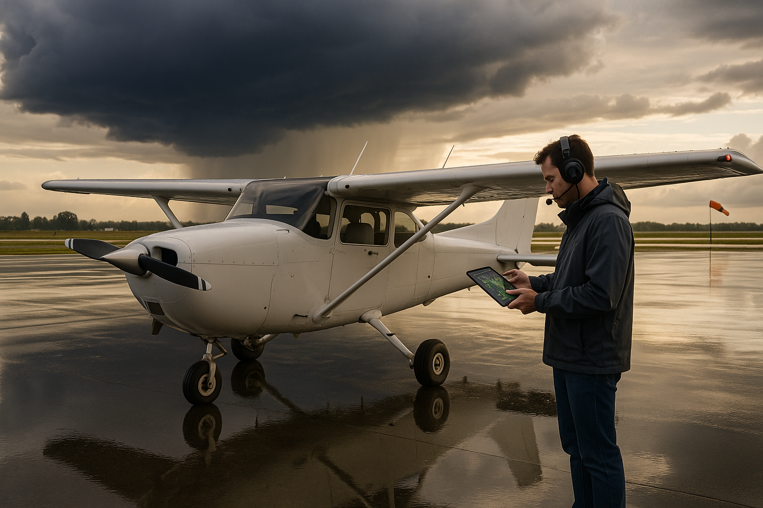
Thunderstorms and Convective Weather
Thunderstorms are a top-tier hazard for GA pilots because they concentrate multiple threats: severe turbulence, lightning, hail, strong and gusty winds, heavy precipitation that reduces visibility, and rapid changes in wind direction and speed. Convective activity can also generate microbursts and intense downdrafts that are particularly dangerous during takeoff and approach.
Operationally, thunderstorms are best treated as nonnegotiable avoidance targets. Radar and satellite products provide valuable situational awareness, but cockpit weather displays are not a license to penetrate convective cores. Pilots should plan routes that keep a wide margin from visible and forecast convective cells, account for outflow boundaries that can extend far from cells, and be prepared to divert early if convection develops along the route.
Airframe Icing and Freezing Precipitation
Icing forms when supercooled liquid water freezes on aircraft surfaces. Ice changes wing shape, increases drag, reduces lift, and adds weight. Even small accumulations can degrade climb performance, stall margins, and control authority. Carburetor and induction icing are additional engine risks for many GA airplanes. Ice can form in visible moisture at temperatures usually between about 0 and -20 degrees Celsius, but formation depends on droplet size and concentration.
For pilots, icing is a numbers and margin problem. Small airplanes often have limited or no ice protection systems, so penetration of forecast or observed icing conditions is unsafe. If icing is possible along the route, plan an alternate that avoids the moisture or routes that stay in warmer layers. Be ready to change altitude to find a temperature inversion or drier air when safe to do so. Recognize early signs of performance degradation and consider diverting before ice accumulates.
Low Ceilings, Reduced Visibility, and Fog
Low ceilings and reduced visibility force flights into instrument conditions. While instrument-rated pilots can operate in IMC, many GA pilots fly VFR and are at special risk from inadvertent encounters. Fog and stratus layers can form quickly, particularly overnight into the morning hours, and night operations compound the hazard.
Before flight, check forecasted ceilings and visibility for route and alternates. Use available surface observations and TAFs to assess timing and trend. If a VFR flight faces a significant chance of IMC, the safest decision can be to delay or choose an alternate route. For instrument-rated pilots, ensure proficiency in approaches and missed approaches and consider weather minimums that preserve a comfortable margin above minima.
Wind Shear and Microbursts
Wind shear is a rapid change in wind speed and/or direction over a short distance. Microbursts are intense, localized downdrafts that spread out on reaching the ground and create strong low-level wind shear. Both are hazardous during takeoff and landing because they can rapidly alter the airspeed and sink rate a pilot sees, producing loss of altitude close to the ground.
Pilots should recognize conditions favorable for microbursts such as convective outflow, late afternoon heating combined with dry air near the surface, or intense thunderstorms. Use runway warnings and observe wind observations, PIREPs, and airport wind indicators. In marginal conditions, increase margins on approach speeds and consider a go-around or diversion when shear is suspected or reported.
Turbulence: Mechanical, Convective, and Mountain Wave
Turbulence ranges from light bumps to violent, aircraft-threatening motion. Mechanical turbulence occurs near the surface where wind interacts with terrain or obstacles. Convective turbulence is associated with thermals and storms. Mountain wave turbulence can produce severe oscillations tens of miles downstream of terrain and may generate strong downdrafts and rotors that can exceed a light aircraft's structural or performance capabilities.
Recognize turbulence risk by observing wind speed, cloud formation, cloud types such as lenticular clouds, and terrain. Anticipate turbulence near ridgelines and valleys, and avoid rotor areas downwind of mountains. When turbulence is expected, secure loose items, brief passengers, slow to the aircraft's recommended turbulence penetration speed, and maintain positive control rather than chasing precise airspeed or altitude.
Density Altitude and Performance Degradation
Density altitude is the pressure altitude corrected for nonstandard temperature. It directly affects engine power, propeller efficiency, and wing lift. High density altitude degrades takeoff performance, climb rates, and landing distance. Hot, high-elevation airports combined with heavy weight can turn routine departures into marginal or impossible operations for some GA aircraft.
Pilots must compute performance for takeoff and landing using the aircraft's performance charts. Adjust weight, reduce payload, choose longer runways, delay departures to cooler parts of the day, and consider leaning the mixture for best power as appropriate for conditions. When operating at high-density-altitude airports, conservative planning and performance margins are essential.
Volcanic Ash, Smoke, and Other Particulates
Volcanic ash and dense smoke are less common hazards but can be catastrophic when encountered. Ash can abrade windshields, pit leading edges, clog filters, and cause partial or total engine failure, particularly in turbine engines. Smoke from wildfires can create extended layers of reduced visibility and create instrument-like conditions for VFR pilots.
These hazards generally require avoiding the affected airspace entirely. Flight planning should include checking NOTAMs and airspace advisories and being prepared to reroute around significant ash or smoke concentrations.
Why This Matters in Real-World Aviation
Weather hazards matter because they create direct threats to safety and because they amplify human and mechanical limitations. A benign weather briefing can change en route into a dangerous situation if pilots do not update information, fail to recognize changing conditions, or feel pressured to continue despite deteriorating weather.
From a training and operational standpoint, weather hazards are where instrument proficiency, judgment, and preflight planning converge. Flight instructors must teach students to combine weather theory with practical decision-making. Operators must craft standard operating procedures that capture conservative go/no-go rules and provide guidance for diversions and alternates. For single-pilot GA operations, the margin for error is smaller than in commercial operations, so conservative choices deliver the highest safety return.
How Pilots Should Understand and Use Weather Information
Weather information comes from multiple streams: surface observations, forecasts, pilot reports, satellite and radar imagery, and official advisories. Each product has strengths and limitations. METARs and TAFs describe current and forecast surface conditions in coded formats. Pilot reports provide in-situ observations. Radar displays show precipitation intensity but may not reveal low-level wind shear or small-scale turbulence. SIGMETs and AIRMETs summarize hazards at a broader scale.
Pilots should build a mental model of the atmosphere along their route. Ask these operational questions: What hazards are present at departure, en route, and destination? How will they change during the planned flight time? What alternates offer safer weather? Which altitudes provide better performance or less moisture? How do terrain and time of day affect local weather processes?
Good preflight weather planning is iterative. Start with a conservative plan, then layer more information as you approach departure. Keep options ready, brief passengers on possible diversions, and maintain situational awareness by refreshing weather products and soliciting PIREPs when available.
Common Mistakes or Misunderstandings
Pilots commonly underestimate the rate at which weather can deteriorate, and they may overestimate the capabilities of their aircraft or their own skills. Specific recurring mistakes include:
- Continuing VFR into marginal conditions because the pilot believes they can stay ahead of the weather. This often leads to inadvertent IMC encounters.
- Misjudging the severity of icing based on ambient temperature only. The presence of visible moisture and droplet characteristics matters more than a single temperature value.
- Relying solely on cockpit weather displays for convective avoidance. Displays have resolution limits and latency; visual observation and conservative separation are still necessary.
- Ignoring density altitude effects at high-elevation or hot airports, resulting in degraded takeoff and climb performance.
- Underestimating wind shear risk near thunderstorms or downwind of strong convective cells during approach and departure.
- Failing to use available aviation weather reports and to seek updated briefings en route.
Addressing these mistakes requires both technical knowledge and procedural discipline. Training scenarios should expose pilots to decision pressure and emphasize diversion as a valid and often safest option.
Practical Example: A Common GA Scenario
Imagine a morning cross-country in a single-engine trainer from a coastal airport to a small inland field with higher terrain. The preflight briefing shows patchy morning fog at the destination with broken ceilings expected to lift by mid-morning, and an approaching line of scattered showers in the afternoon. Surface winds are light at departure, with stronger afternoon southerly winds forecast near the destination.
Operational approach:
- Plan a conservative departure time to arrive after the forecast lift of the fog. Identify an alternate with forecast VFR conditions or with instrument approach capability.
- Consider weight and fuel—higher atmospheric moisture and temperature can increase takeoff distance. Compute takeoff performance given the current temperature and pressure.
- During flight, monitor updated METARs and TAFs for the destination and alternates. If convective development appears upstream, divert early rather than trying to make the original plan.
- On approach, be alert for wind shifts and gusts signaling convective outflows. If visibility or ceiling deteriorates below personal or legal minima, execute a missed approach and fly to the alternate.
This scenario frames how weather hazards intersect with planning, performance, and decision-making. The safest outcome often requires postponing or diverting rather than attempting a marginal arrival.
Best Practices for Pilots
Adopt these practical habits to reduce weather-related risk:
- Make conservative go/no-go decisions. Prioritize avoiding the hazard rather than mitigating the consequence in flight.
- Brief passengers on the weather plan and the possibility of diversion. Removing surprise reduces pilot pressure to continue.
- Use multiple weather sources. Combine official briefings, METAR/TAF, PIREPs, radar, and local knowledge to build a complete picture.
- Practice recognition and recovery techniques for inadvertent IMC, icing encounters, and wind shear in a simulator or dual instruction environment.
- Manage aircraft configuration and speed for turbulence. Use recommended turbulence penetration speeds and maintain positive control over precise altitude or airspeed tracking.
- Plan for density altitude. Recalculate performance for hot or high-elevation operations and reduce weight where necessary.
- Keep proficiency current. Regular instrument and cross-country practice reduces the likelihood of weather-related surprises turning into emergencies.
Frequently Asked Questions
Can a small GA airplane safely fly through a thunderstorm?
No. Penetrating a thunderstorm exposes a GA airplane to severe turbulence, hail, lightning, and strong downdrafts or microbursts. Avoid thunderstorms by a wide margin and use available radar and visual cues to stay well clear.
How can I reduce the risk of icing during winter flights?
Plan routes and altitudes that avoid visible moisture where temperatures are conducive to icing. If icing is encountered, leave the moisture by changing altitude or turning to warmer or drier air. If your airplane lacks adequate deice or anti-ice equipment, avoid forecast or observed icing entirely.
What symptoms suggest I have encountered wind shear on approach?
Rapid airspeed changes, sudden sink, or unexpected deviations from the desired glidepath suggest wind shear. If wind shear is suspected on approach, add appropriate safety speed, be prepared for a go-around, and follow the airplane manufacturer guidance for wind shear recovery.
How should I use METARs and TAFs during flight planning?
Use METARs to understand current surface conditions and trends. TAFs offer a forecast for airport conditions. Combine both with radar and pilot reports to form a probable scenario. Update the plan if METARs or TAF amendments show deteriorating conditions.
When should I cancel a VFR flight because of weather?
Cancel or postpone a VFR flight when the forecast or current conditions reduce margins below your personal minimums, when the flight will likely require flight into instrument conditions that you are not prepared to handle, or when convective or icing hazards are present. Conservative decisions prevent situations that require emergency responses.
Key Takeaways
- Practical takeaway: Build a conservative weather plan, include alternates, and update it en route to stay ahead of evolving hazards.
- Safety takeaway: Avoid thunderstorms and icing; these hazards quickly exceed the capabilities of many GA aircraft and pilots.
- Training takeaway: Regular instrument and weather-specific training reduces risk and improves decision-making under changing conditions.
Weather hazards for GA pilots are predictable in the sense that we can identify conditions that create risk, but unpredictable in timing and intensity. The most effective defenses are conservative planning, continuous information updates, and willingness to divert. Training that integrates weather recognition, simulator practice, and real-world decision-making will reduce the frequency and severity of weather-related incidents.
If you are an instructor, integrate realistic weather scenarios into training flights and debriefs. If you are a pilot, make weather briefing and decisional discipline part of every flight. That combination of knowledge and judgment is the foundation of safe, resilient general aviation operations.