
Chapter 12
Weather Theory
If rain falls through a temperature inversion, it may freeze as it passes through the underlying cold air and fall to the ground in the form of ice pellets. Ice pellets are an indication of a temperature inversion and that freezing rain exists at a higher altitude. In the case of hail, freezing water droplets are carried up and down by drafts inside cumulonimbus clouds, growing larger in size as they come in contact with more moisture. Once the updrafts can no longer hold the freezing water, it falls to the Earth in the form of hail. Hail can be pea sized, or it can grow as large as five inches in diameter, larger than a softball.
Snow is precipitation in the form of ice crystals that falls at a steady rate or in snow showers that begin, change in intensity, and end rapidly. Snow also varies in size, from very small grains to large flakes. Snow grains are the equivalent of drizzle in size.
Precipitation in any form poses a threat to safety of flight. Often, precipitation is accompanied by low ceilings and reduced visibility. Aircraft that have ice, snow, or frost on their surfaces must be carefully cleaned prior to beginning a flight because of the possible airflow disruption and loss of lift. Rain can contribute to water in the fuel tanks. Precipitation can create hazards on the runway surface itself, making takeoffs and landings difficult, if not impossible, due to snow, ice, or pooling water and very slick surfaces.
Air Masses
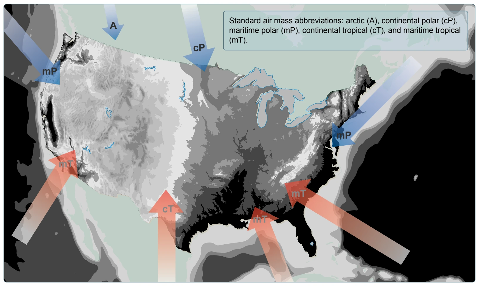
Air masses are classified according to the regions where they originate. They are large bodies of air that take on the characteristics of the surrounding area or source region. A source region is typically an area in which the air remains relatively stagnant for a period of days or longer. During this time of stagnation, the air mass takes on the temperature and moisture characteristics of the source region. Areas of stagnation can be found in polar regions, tropical oceans, and dry deserts. Air masses are generally identified as polar or tropical based on temperature characteristics and maritime or continental based on moisture content.
A continental polar air mass forms over a polar region and brings cool, dry air with it. Maritime tropical air masses form over warm tropical waters like the Caribbean Sea and bring warm, moist air. As the air mass moves from its source region and passes over land or water, the air mass is subjected to the varying conditions of the land or water which modify the nature of the air mass. [Figure 12-23]
An air mass passing over a warmer surface is warmed from below, and convective currents form, causing the air to rise. This creates an unstable air mass with good surface visibility. Moist, unstable air causes cumulus clouds, showers, and turbulence to form.
Conversely, an air mass passing over a colder surface does not form convective currents but instead creates a stable air mass with poor surface visibility. The poor surface visibility is due to the fact that smoke, dust, and other particles cannot rise out of the air mass and are instead trapped near the surface. A stable air mass can produce low stratus clouds and fog.
Fronts
As an air mass moves across bodies of water and land, it eventually comes in contact with another air mass with different characteristics. The boundary layer between two types of air masses is known as a front. An approaching front of any type always means changes to the weather are imminent.
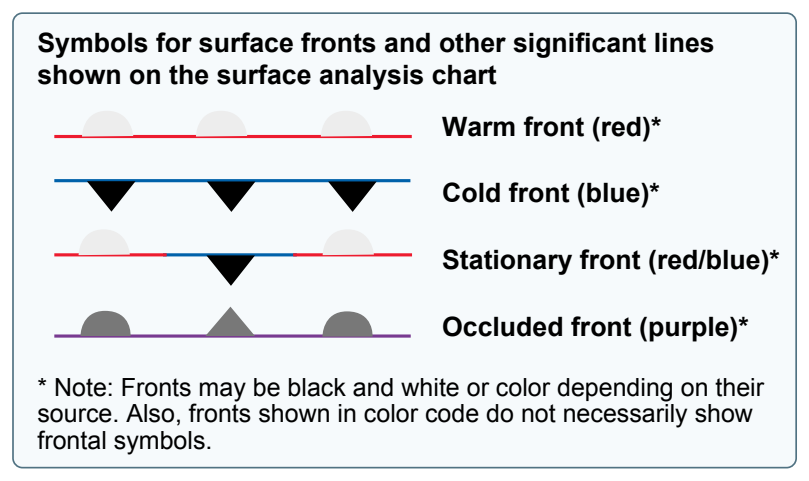
There are four types of fronts that are named according to the temperature of the advancing air relative to the temperature of the air it is replacing: [Figure 12-24]
- Warm
- Cold
- Stationary
- Occluded
Any discussion of frontal systems must be tempered with the knowledge that no two fronts are the same. However, generalized weather conditions are associated with a specific type of front that helps identify the front.
Warm Front
A warm front occurs when a warm mass of air advances and replaces a body of colder air. Warm fronts move slowly, typically 10 to 25 miles per hour (mph). The slope of the advancing front slides over the top of the cooler air and gradually pushes it out of the area. Warm fronts contain warm air that often has very high humidity. As the warm air is lifted, the temperature drops and condensation occurs.
Generally, prior to the passage of a warm front, cirriform or stratiform clouds, along with fog, can be expected to form along the frontal boundary. In the summer months, cumulonimbus clouds (thunderstorms) are likely to develop.
Light to moderate precipitation is probable, usually in the form of rain, sleet, snow, or drizzle, accentuated by poor visibility. The wind blows from the south-southeast, and the outside temperature is cool or cold with an increasing dew point. Finally, as the warm front approaches, the barometric pressure continues to fall until the front passes completely.
During the passage of a warm front, stratiform clouds are visible and drizzle may be falling. The visibility is generally poor, but improves with variable winds. The temperature rises steadily from the inflow of relatively warmer air. For the most part, the dew point remains steady and the pressure levels off. After the passage of a warm front, stratocumulus clouds predominate and rain showers are possible. The visibility eventually improves, but hazy conditions may exist for a short period after passage. The wind blows from the south-southwest. With warming temperatures, the dew point rises and then levels off. There is generally a slight rise in barometric pressure, followed by a decrease of barometric pressure.