
Chapter 16
Navigation
To determine the magnetic bearing “FROM” the station, 180° is added to or subtracted from the magnetic bearing to the station. This is the reciprocal bearing and is used when plotting position fixes.
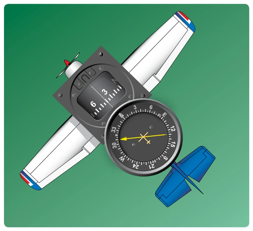
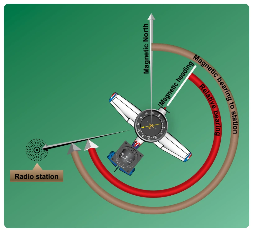
Keep in mind that the needle of fixed azimuth points to the station in relation to the nose of the aircraft. If the needle is deflected 30° to the left for a relative bearing of 330°, this means that the station is located 30° left. If the aircraft is turned left 30°, the needle moves to the right 30° and indicates a relative bearing of 0° meaning that the aircraft is pointing toward the station. If the pilot continues flight toward the station keeping the needle on 0°, the procedure is called homing to the station. If a crosswind exists, the ADF needle continues to drift away from zero. To keep the needle on zero, the aircraft must be turned slightly resulting in a curved flight path to the station. Homing to the station is a common procedure but may result in drifting downwind, thus lengthening the distance to the station.
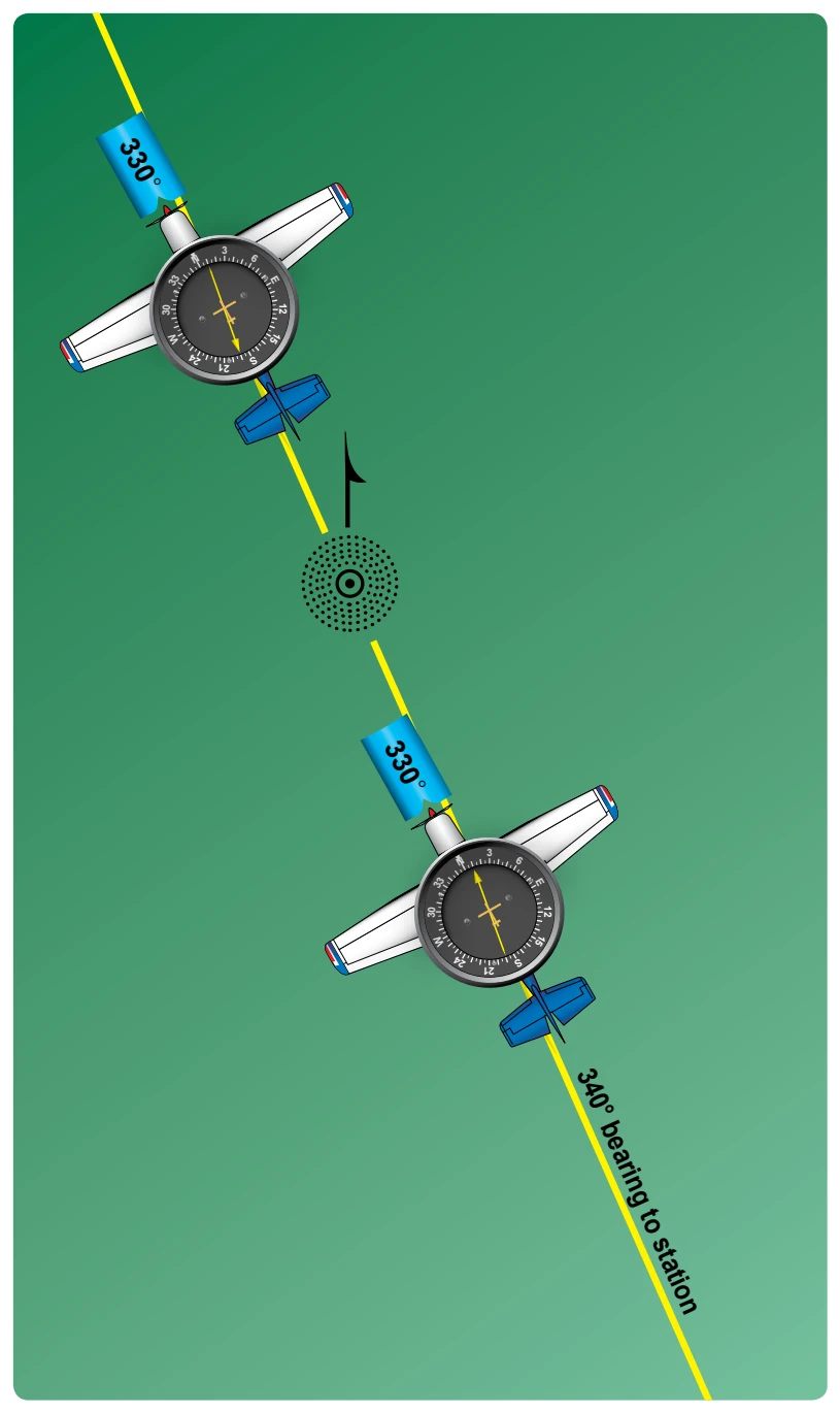
Tracking to the station requires correcting for wind drift and results in maintaining flight along a straight track or bearing to the station. When the wind drift correction is established, the ADF needle indicates the amount of correction to the right or left. For instance, if the magnetic bearing to the station is 340°, a correction for a left crosswind would result in a magnetic heading of 330°, and the ADF needle would indicate 10° to the right or a relative bearing of 010°. [Figure 16-39]
When tracking away from the station, wind corrections are made similar to tracking to the station, but the ADF needle points toward the tail of the aircraft or the 180° position on the azimuth dial. Attempting to keep the ADF needle on the 180° position during winds results in the aircraft flying a curved flight leading further and further from the desired track. When tracking outbound, corrections for wind should be made in the direction opposite of that in which the needle is pointing.
Although the ADF is not as popular as the VOR for radio navigation, with proper precautions and intelligent use, the ADF can be a valuable aid to navigation.
Global Positioning System
The GPS is a satellite-based radio navigation system. Its RNAV guidance is worldwide in scope. There are no symbols for GPS on aeronautical charts as it is a space-based system with global coverage. Development of the system is underway so that GPS is capable of providing the primary means of electronic navigation. Portable and yoke-mounted units are proving to be very popular in addition to those permanently installed in the aircraft. Extensive navigation databases are common features in aircraft GPS receivers.
The GPS is a satellite radio navigation and time dissemination system developed and operated by the U.S. Department of Defense (DOD). Civilian interface and GPS system status is available from the U.S. Coast Guard.
It is not necessary to understand the technical aspects of GPS operation to use it in VFR/IFR navigation. It does differ significantly from conventional, ground-based electronic navigation and awareness of those differences is important. Awareness of equipment approvals and limitations is critical to the safety of flight.
The GPS navigation system broadcasts a signal that is used by receivers to determine precise position anywhere in the world. The receiver tracks multiple satellites and determines a pseudorange measurement to determine the user location. A minimum of four satellites is necessary to establish an accurate three-dimensional position. The Department of Defense (DOD) is responsible for operating the GPS satellite constellation and monitors the GPS satellites to ensure proper operation.
The status of a GPS satellite is broadcast as part of the data message transmitted by the satellite. GPS status information is also available from the U.S. Coast Guard navigation information service at (703) 313-5907 or online at www. navcen.uscg.gov. Additionally, satellite status is available through the NOTAM system.
The GPS receiver verifies the integrity (usability) of the signals received from the GPS constellation through receiver autonomous integrity monitoring (RAIM) to determine if a satellite is providing corrupted information. At least one satellite, in addition to those required for navigation, must be in view for the receiver to perform the RAIM function; thus, RAIM needs a minimum of five satellites in view or four satellites and a barometric altimeter (baro-aiding) to detect an integrity anomaly. For receivers capable of doing so, RAIM needs six satellites in view (or five satellites with baro-aiding) to isolate the corrupt satellite signal and remove it from the navigation solution. Baro-aiding is a method of augmenting the GPS integrity solution by using a nonsatellite input source. GPS derived altitude should not be relied upon to determine aircraft altitude since the vertical error can be quite large and no integrity is provided. To ensure that baro-aiding is available, the current altimeter setting must be entered into the receiver as described in the operating manual.
RAIM messages vary somewhat between receivers; however, generally there are two types. One type indicates that there are not enough satellites available to provide RAIM integrity monitoring and another type indicates that the RAIM integrity monitor has detected a potential error that exceeds the limit for the current phase of flight. Without RAIM capability, the pilot has no assurance of the accuracy of the GPS position.
Selective Availability
Selective Availability (SA) is a method by which the accuracy of GPS is intentionally degraded. This feature is designed to deny hostile use of precise GPS positioning data. SA was discontinued on May 1, 2000, but many GPS receivers are designed to assume that SA is still active.
The baseline GPS satellite constellation consists of 24 satellites positioned in six earth-centered orbital planes with four operation satellites and a spare satellite slot in each orbital plane. The system can support a constellation of up to thirty satellites in orbit. The orbital period of a GPS satellite is one-half of a sidereal day or 11 hours 58 minutes. The orbits are nearly circular and equally spaced about the equator at a 60-degree separation with an inclination of 55 degrees relative to the equator. The orbital radius (i.e. distance from the center of mass of the earth to the satellite) is approximately 26,600 km.
With the baseline satellite constellation, users with a clear view of the sky have a minimum of four satellites in view. It is more likely that a user would see six to eight satellites. The satellites broadcast ranging signals and navigation data allowing users to measure their pseudoranges in order to estimate their position, velocity and time, in a passive, listen-only mode. The receiver uses data from a minimum of four satellites above the mask angle (the lowest angle above the horizon at which a receiver can use a satellite). The exact number of satellites operating at any one particular time varies depending on the number of satellite outages and operational spares in orbit. For current status of the GPS constellation, please visit http://tycho.usno.navy.mil/gpscurr. html. [Figure 16-40]