Chapter 3
Overview of Aviation Weather Information
FIS-B over Universal Access Transceiver (UAT) datalink service provides aeronautical information and meteorological information to the flight deck for aircraft operating in the NAS. These products are broadcast over the Automatic Dependent Surveillance-Broadcast (ADS-B) UAT link so that pilots have timely information of regional weather and NAS status/changes that might affect flight. FIS-B aeronautical information and meteorological information products provide strategic information to the flight deck that enhances a preflight briefing. FIS-B products do not include all NOTAMs.
Advisory Circular (AC) 00-63, Use of Flight Deck Displays of Digital Weather and Aeronautical Information, contains detailed information concerning FIS-B meteorological products. The AIM Chapter 3, Airspace; Chapter 4, Air Traffic Control; and Chapter 5, Air Traffic Procedures, contain information on Special Use Airspace (SUA), TFR, and NOTAM products.
FIS-B update intervals are defined as the rate at which the product data is available from the source. Transmission intervals are defined as the amount of time within which a new or updated product transmission must be completed and the rate or repetition interval at which the product is rebroadcast. Refer to the AIM, Chapter 7, Section 1, Table 7-1-3, FIS-B Over UAT Product Update and Transmission Intervals, for update and transmission intervals for each FIS-B product.
Where applicable, FIS-B products include a look-ahead range expressed in nautical miles for three service domains: Airport Surface, Terminal Airspace, and En Route/Gulf of America. The AIM, Chapter 7, Section 1, Table 7-1-4, Product Parameters for Low/Medium/High Altitude Tier Radios, provides service domain availability and look-ahead ranging for each FIS-B product.
Details on the content, format, and symbology of individual FIS-B products can be obtained from the manufacturer of the avionics equipment used to receive and display them.
3.3.4.2 Automated Surface Observing System (ASOS) and Automated Weather Observing System (AWOS)
ASOS and AWOS information can be retrieved in flight. Typically, the range of an ASOS/AWOS broadcast is 25 NM. ASOS and AWOS frequencies are printed on Sectional Charts and listed in FAA Chart Supplements. The majority of ASOS and AWOS are on airports, but there are a few located off-airport, such as in a mountain pass. See Section 24.3 for more information on ASOS and AWOS.
3.3.4.3 Automatic Terminal Information Service (ATIS)
The Automatic Terminal Information Service (ATIS) is a continuous broadcast on an assigned frequency of recorded information in selected terminal areas to provide pilots with necessary airport and local area information prior to arrival or departure.
ATIS frequencies can be found on Sectional Charts and Chart Supplements, as well as on instrument approach charts.
The ATIS broadcast is updated upon the receipt of new hourly weather, special weather, or when there is a change in other pertinent data, such as runway change, instrument approach in use, etc.
3.3.4.4 Flight Service
FSS specialists provide in-flight weather updates as well as collect PIREPs. FSS frequencies are listed on Sectional Charts and Chart Supplements.
3.3.4.5 Automatic Flight Information Service (AFIS) – Alaska Only
The Automatic Flight Information Service (AFIS) provides a continuous broadcast of recorded non-control information at airports in Alaska where Flight Service provides local airport advisory (LAA) service. The AFIS broadcast automates the repetitive transmission of essential but routine information, such as weather, wind, altimeter, favored runway, braking action, airport NOTAMs, and other applicable information. The information is continuously broadcast over a discrete very high frequency (VHF) radio frequency (usually the ASOS frequency). When rapidly changing conditions exist, the ceiling, visibility, altimeter, wind, or other conditions may be omitted from the AFIS and will be issued by the FSS specialist on the appropriate radio frequency. AFIS frequencies can be found on Sectional Charts and the Alaska Chart Supplement.
3.4 Overview of Aviation Weather Products
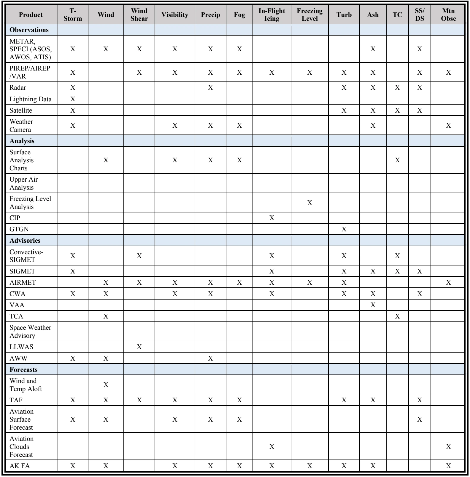
There are many aviation weather products available to the pilot through the internet and mobile phone apps. Each product has a specific purpose that provides the user with reported or forecast weather conditions either at an airport or aloft. Table 3-1 and Table 3-2 are matrices of aviation weather products versus the weather elements and the weather phenomena applicable to aviation. These tables are a high-level overview and do not attempt to capture all products and elements.
A brief summary of the weather products that contain information pertaining to each weather element and weather phenomenon is provided in individual tables in the next section. Technical specifications (e.g., codes and contents) pertaining to the products in Table 3-1 and Table 3-2, as well as others, are provided in Chapters 24, 25, 26, 27, and 28.
3.4.1 Weather Products versus Weather Elements and Phenomena