
Appendix D: Special Terminal Operation Procedures (STOP) for Operations in a Noncontiguous State
D.1 Introduction
Air carriers often need to release flights to locations with missing weather reports (e.g., surface observations such as METAR), missing elements of weather reports, or locations that do not have an ASOS or AWOS facility or human weather observers.
The STOP program is designed for 14 CFR part 121 domestic and supplemental operations at airports in a noncontiguous state (e.g., Alaska) without a complete surface observation and/or forecast.
This guidance provides acceptable methods and guidelines for the certificate holder (CH) to use to develop the STOP program. The Aviation Safety Inspector—Aircraft Dispatch (ASI-AD) and the POI may refer to this guidance as they review 14 CFR part 121 domestic or supplemental operations conducted in a noncontiguous state to airports with no METARs, missing METAR elements, or no weather reporting facilities.
D.2 Weather Information
D.2.1 General
In accordance with 14 CFR § 121.599(a), no aircraft dispatcher may release a flight unless thoroughly familiar with reported and forecast weather conditions on the route to be flown. Title 14 CFR § 121.601 requires the aircraft dispatcher to provide the PIC with all available current reports or information on airport conditions and irregularities of navigation facilities that may affect the safety of the flight. Title 14 CFR § 121.601 applies to every phase of flight. In accordance with 14 CFR § 121.599(b), no PIC may begin a flight unless thoroughly familiar with reported and forecast weather conditions on the route to be flown. Title 14 CFR § 121.597 refers to the individuals authorized by the CH to exercise operational control over the flight and to execute a flight release setting forth the conditions under which the flights will be conducted.
IFR operations under 14 CFR part 121 require current weather reports and forecasts. Those approved sources are official surface observation (e.g., METAR) and a TAF. If no NWS TAF is available, an approved EWINS TAF may be used. Refer to FAA Order 8900.1 Volume 3, Chapter 26, Section 4, Enhanced Weather Information Systems, for additional information about EWINS.
Landing limitations and aircraft performance require a CH to consider forecast (anticipated/probable) winds at the destination airport. Therefore, weather forecasts that include wind information for the destination airport are always required.
D.2.2 Supplements to NWS or EWINS TAFs
The AAG forecast product provides TAF-like information for locations where an NWS or EWINS TAF is not available at the intended destination in Alaska. The AAG is intended for use under visual meteorological conditions (VMC). Operators conducting operations under 14 CFR part 121 cannot use the AAG at alternate airports. The AAG is also limited for flight times of two hours or less in duration. The AAG, in conjunction with METARs, PIREPs, the FA, SIGMETs, and AIRMETs, helps inform operators of the weather conditions at the ETA and whether those conditions will be at or above the minimums, which determines whether operations can be conducted within the performance limitations of the aircraft per 14 CFR § 121.101. In addition, the AAG does not indicate blowing snow or convective activity. If precipitation is forecasted, other products, including SIGMETs and NEXRAD weather radar, where available, can determine if hazardous convective weather will be present when the aircraft arrives. InFO 20002 provides more information on the AAG.
Table D-1 lists weather products that supplement NWS or EWINS TAFs.
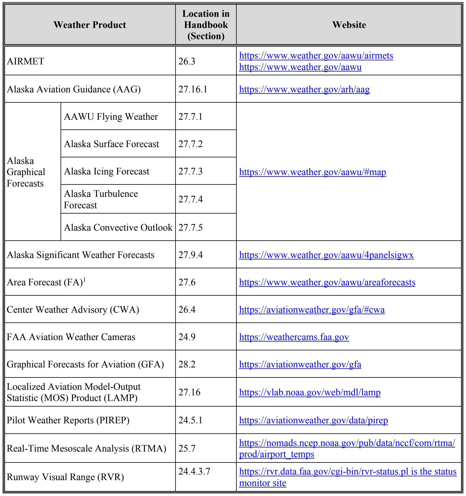
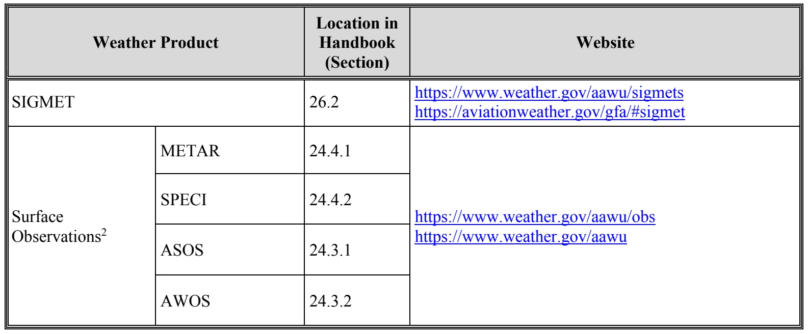
Notes:
- An FA alone, without a valid TAF, is not an acceptable standalone forecast to satisfy the relevant 14 CFR part 121 weather reporting requirements. The FA is not intended for use in operational decision making or as a substitute for a TAF. However, the FA may provide vital weather information for the entire en route portion of flight, from point of origin to destination and all applicable alternates.
- Aircraft performance is predicated on aircraft weight, ambient temperature, wind direction, wind speed, and altimeter setting. In order to ensure aircraft takeoff and landing limitations are met and obstacles are avoided, a surface observation contains at least the following elements:
- The station identifier (e.g., airport code),
- Date and time of observation (to establish relevance of the report),
- Ambient air temperature at the station (e.g., airport or seaport),
- Wind speed and direction,
- Altimeter setting at the station (unless the current published approach plate lists an alternate source),
- Visibility (for obstacle avoidance and IAPs), and
- Ceiling.
D.2.3 Manual Surface Observations by Flightcrews Using a Portable Weather Observation Device at STOP Airports
D.2.3.1 Portable Weather Observation Device
A portable weather observation device is issued to the flightcrews who conduct STOP flights as part of the preflight preparation. An acceptable portable weather observation device provides the following:
- Date and time
- Wind direction (degrees magnetic north)
- Wind speed (knots)
- Temperature (°C)
- Dewpoint temperature (°C)
- Altimeter or pressure (inHg)