
Chapter 12
Weather Theory
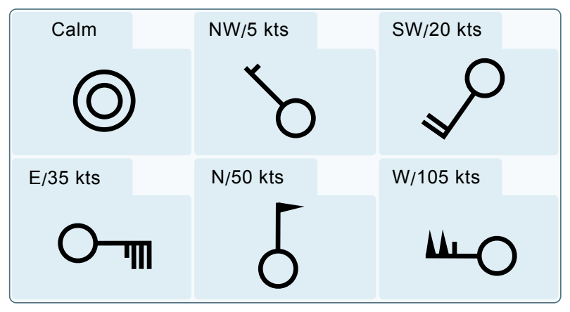
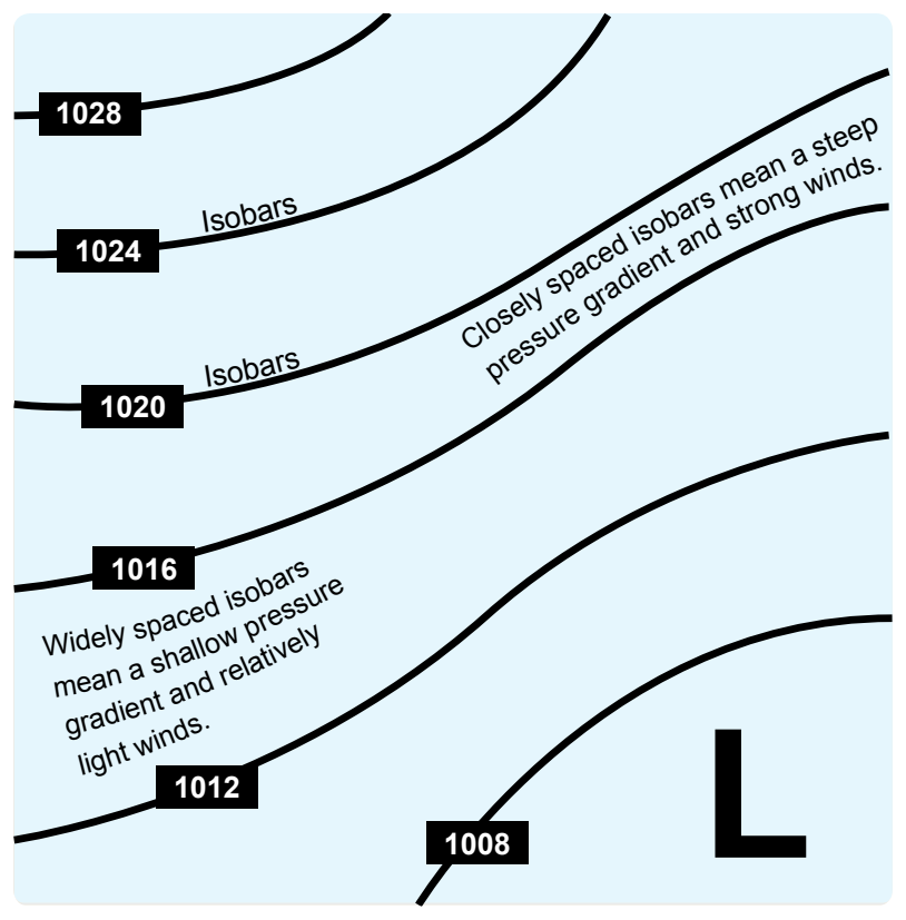
wind direction is modified by the friction and wind speed decreases due to friction with the surface. At levels 2,000 to 3,000 feet above the surface, however, the speed is greater and the direction becomes more parallel to the isobars.
Generally, the wind 2,000 feet above ground level (AGL) is 20° to 40° to the right of surface winds, and the wind speed is greater. The change of wind direction is greatest over rough terrain and least over flat surfaces, such as open water. In the absence of winds aloft information, this rule of thumb allows for a rough estimate of the wind conditions a few thousand feet above the surface.
Atmospheric Stability
The stability of the atmosphere depends on its ability to resist vertical motion. A stable atmosphere makes vertical movement difficult, and small vertical disturbances dampen out and disappear. In an unstable atmosphere, small vertical air movements tend to become larger, resulting in turbulent airflow and convective activity. Instability can lead to significant turbulence, extensive vertical clouds, and severe weather.
Rising air expands and cools due to the decrease in air pressure as altitude increases. The opposite is true of descending air; as atmospheric pressure increases, the temperature of descending air increases as it is compressed. Adiabatic heating and adiabatic cooling are terms used to describe this temperature change.
The adiabatic process takes place in all upward and downward moving air. When air rises into an area of lower pressure, it expands to a larger volume. As the molecules of air expand, the temperature of the air lowers. As a result, when a parcel of air rises, pressure decreases, volume increases, and temperature decreases. When air descends, the opposite is true. The rate at which temperature decreases with an increase in altitude is referred to as its lapse rate. As air ascends through the atmosphere, the average rate of temperature change is 2 °C (3.5 °F) per 1,000 feet.
Since water vapor is lighter than air, moisture decreases air density, causing it to rise. Conversely, as moisture decreases, air becomes denser and tends to sink. Since moist air cools at a slower rate, it is generally less stable than dry air since the moist air must rise higher before its temperature cools to that of the surrounding air. The dry adiabatic lapse rate (unsaturated air) is 3 °C (5.4 °F) per 1,000 feet. The moist adiabatic lapse rate varies from 1.1 °C to 2.8 °C (2 °F to 5 °F) per 1,000 feet.
The combination of moisture and temperature determine the stability of the air and the resulting weather. Cool, dry air is very stable and resists vertical movement, which leads to good and generally clear weather. The greatest instability occurs when the air is moist and warm, as it is in the tropical regions in the summer. Typically, thunderstorms appear on a daily basis in these regions due to the instability of the surrounding air.
Inversion
As air rises and expands in the atmosphere, the temperature decreases. There is an atmospheric anomaly that can occur; however, that changes this typical pattern of atmospheric behavior. When the temperature of the air rises with altitude, a temperature inversion exists. Inversion layers are commonly shallow layers of smooth, stable air close to the ground. The temperature of the air increases with altitude to a certain point, which is the top of the inversion. The air at the top of the layer acts as a lid, keeping weather and pollutants trapped below. If the relative humidity of the air is high, it can contribute to the formation of clouds, fog, haze, or smoke resulting in diminished visibility in the inversion layer.
Surface-based temperature inversions occur on clear, cool nights when the air close to the ground is cooled by the lowering temperature of the ground. The air within a few hundred feet of the surface becomes cooler than the air above it. Frontal inversions occur when warm air spreads over a layer of cooler air, or cooler air is forced under a layer of warmer air.
Moisture and Temperature
The atmosphere, by nature, contains moisture in the form of water vapor. The amount of moisture present in the atmosphere is dependent upon the temperature of the air. Every 20 °F increase in temperature doubles the amount of moisture the air can hold. Conversely, a decrease of 20 °F cuts the capacity in half.
Water is present in the atmosphere in three states: liquid, solid, and gaseous. All three forms can readily change to another, and all are present within the temperature ranges of the atmosphere. As water changes from one state to another, an exchange of heat takes place. These changes occur through the processes of evaporation, sublimation, condensation, deposition, melting, or freezing. However, water vapor is added into the atmosphere only by the processes of evaporation and sublimation.
Evaporation is the changing of liquid water to water vapor. As water vapor forms, it absorbs heat from the nearest available source. This heat exchange is known as the latent heat of evaporation. A good example is the evaporation of human perspiration. The net effect is a cooling sensation as heat is extracted from the body. Similarly, sublimation is the changing of ice directly to water vapor, completely bypassing the liquid stage. Though dry ice is not made of water, but rather carbon dioxide, it demonstrates the principle of sublimation when a solid turns directly into vapor.
Relative Humidity
Humidity refers to the amount of water vapor present in the atmosphere at a given time. Relative humidity is the actual amount of moisture in the air compared to the total amount of moisture the air could hold at that temperature. For example, if the current relative humidity is 65 percent, the air is holding 65 percent of the total amount of moisture that it is capable of holding at that temperature and pressure. While much of the western United States rarely sees days of high humidity, relative humidity readings of 75 to 90 percent are not uncommon in the southern United States during warmer months. [Figure 12-20]