Searchable VFR Flyway Planning Chart symbols and explanations for pilots.
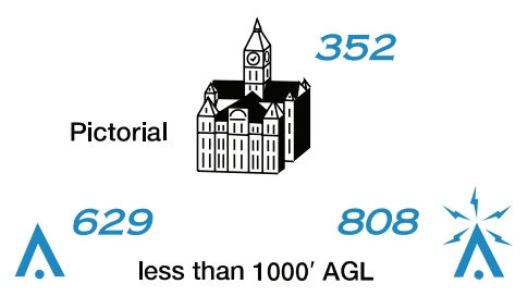
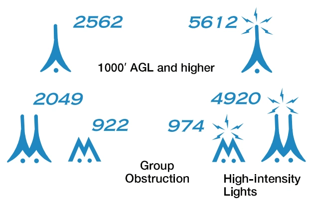
Obstruction-symbol legend — less than 1,000 ft and 1,000 ft or higher AGL — source page 47.
Obstacles may be lit or unlit.
Only obstacles greater than
999’ above ground level (AGL)
or specified by the local ATC
Facility shall be shown.
AGL heights are not shown.
High-intensity obstruction-light symbols — source page 47.
High-intensity lights may
operate part-time or by
proximity activation.
Under Construction or reported
Under-construction and unverified obstruction symbols — source page 47.
and position/elevation unverified.
NAVIGATIONAL AND PROCEDURAL INFORMATION
Suggested VFR Flyway And Altitude Military Training Routes (MTR) VFR Checkpoints Underline indicates proper name of VFR Checkpoint VFR Waypoints Stand-Alone Collocated with VFR Checkpoint Navigational Data Obstructions Obstacles may be lit or unlit. Only obstacles greater than 999’ above ground level (AGL) or specified by the local ATC Facility shall be shown. AGL heights are not shown. High-intensity lights may operate part-time or by proximity activation. Under Construction or reported and position/elevation unverified. AIRSPACE INFORMATION (Continued) NAVIGATIONAL AND PROCEDURAL INFORMATION
Source page 48
We use cookies to operate this website, improve performance, understand site traffic, and personalize your experience. Essential cookies are always active because they are required for the website to function.
Required for basic site functionality and security.
Help us understand how visitors use the website so we can improve it.
May be used for advertising, remarketing, or social media features.
You can update your choices anytime using Cookie Settings. View Privacy Policy