Aviation Training Experts™

other

Aeronautical Chart Users’ Guide

FAA Chart Users’ Guide Version 9 July 2026

VFR Flyway Planning Charts

Searchable VFR Flyway Planning Chart symbols and explanations for pilots.

Special Conservation Areas
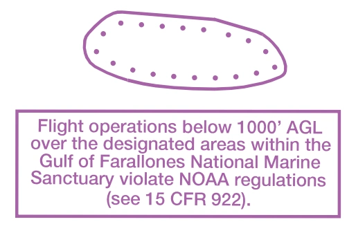
FAA aeronautical chart visual associated with “NOAA-regulated National Marine Sanctuary boundary and notice” (source page 46).
NOAA-regulated National Marine Sanctuary boundary and notice — source page 46.
NOAA Regulated National Marine
Sanctuary Designated Areas

Mode C (FAR 91.215)

FAA aeronautical chart visual associated with “Mode C and ADS-B Out 30 NM boundary — VFR Flyway Planning Charts” (source page 46).
Mode C and ADS-B Out 30 NM boundary — VFR Flyway Planning Charts — source page 46.
Appropriate notes as required may be shown.

Sporting Event Temporary Flight Restriction (TFR) Sites

FAA aeronautical chart visual associated with “Stadium / sporting-event temporary-flight-restriction landmark” (source page 46).
Stadium / sporting-event temporary-flight-restriction landmark — source page 46.

National Defense Airspace Temporary Flight Restriction (TFR) Areas

FAA aeronautical chart visual associated with “National Defense Airspace temporary-TFR hatched boundary” (source page 46).
National Defense Airspace temporary-TFR hatched boundary — source page 46.
FAA aeronautical chart visual associated with “Dallas National Defense Airspace TFR — Check NOTAMs” (source page 46).
Dallas National Defense Airspace TFR — Check NOTAMs — source page 46.

Miscellaneous Activity Areas

FAA aeronautical chart visual associated with “Miscellaneous activity-area symbols — aerobatic, glider, hang glider, ultralight, UAS, parachute, space launch” (source page 46).
Miscellaneous activity-area symbols — aerobatic, glider, hang glider, ultralight, UAS, parachute, space launch — source page 46.
Aerobatic Practice Area
Glider Operations
Hang Glider Activity
Ultralight Activity
Unmanned Aircraft Activity
Parachute Jumping Area