Responsive VFR Sectional and Terminal Area Chart legends for airports, radio aids, airspace, procedures, culture, hydrography, and relief.
Lighting limitations exist; refer to Chart Supplement
Length of longest runway in hundreds of feet; usable length may be less.
Aeronautical advisory station
Runways with Right Traffic Patterns (public use)
See Chart Supplement
VFR Advisory Service Shown when ATIS is not available and frequency is other than the primary CT frequency.
Weather Camera
Airport of Entry
When information is lacking. the respective character is replaced by a dash. Lighting codes refer to runway edge lights and may not represent the longest runway or full length lighting.
AIRPORTS (Continued) Seaplane Airport Data Grouping Boxed airport name indicates airport for which a Special Traffic Rule has been established. (Pvt): Non-public use having landmark value. “OBJECTIONABLE”: This airport may adversely affect airspace use. Facility No Fuel Facility With Fuel Non-Towered Towered Facility With Runway and Waterway Non Towered Towered UNICOM UNICOM Flight Service Station on field Airports where fixed wing special VFR operations are prohibited (shown above airport name) FAR 91 Indicates FAR 93 Special Air Traffic Rules and Airport Traffic Pattern Location Identifier ICAO Location Identifier Control Tower (CT) - primary frequency Star indicates operation part-time. See tower frequencies tabulation for hours of operation Follows the Common Traffic Advisory Frequency (CTAF) Automatic Terminal Information Services Automatic Flight Information Service Automated Surface Weather Observing Systems; shown when full-time ATIS is not available. Elevation in feet Lighting in operation Sunset to Sunrise Lighting limitations exist; refer to Chart Supplement Length of longest runway in hundreds of feet; usable length may be less. Aeronautical advisory station Runways with Right Traffic Patterns (public use) See Chart Supplement VFR Advisory Service Shown when ATIS is not available and frequency is other than the primary CT frequency. Weather Camera Airport of Entry When information is lacking. the respective character is replaced by a dash. Lighting codes refer to runway edge lights and may not represent the longest runway or full length lighting.
Source page 25
RADIO AIDS TO NAVIGATION
VOR
VORTAC — source page 25.
VORTAC
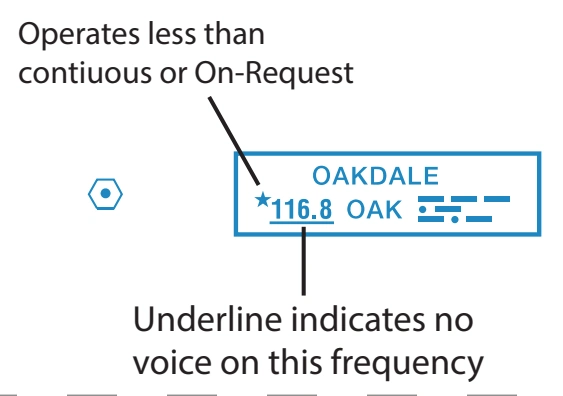
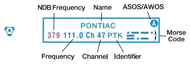
When an NDB NAVAID shares the same name and Morse Code as the VOR NAVAID the frequency can be collocated inside the same box to conserve space. — source page 25.
When an NDB NAVAID shares the same name and Morse Code as the VOR NAVAID the frequency can be collocated inside the same box to conserve space.
VOR-DME
DME — source page 25.
DME
Cookie Preferences
We use cookies to operate this website, improve performance, understand site traffic, and personalize your experience. Essential cookies are always active because they are required for the website to function.
Required for basic site functionality and security.
Help us understand how visitors use the website so we can improve it.
May be used for advertising, remarketing, or social media features.
You can update your choices anytime using Cookie Settings. View Privacy Policy