
Chapter 13
Atmospheric Stability
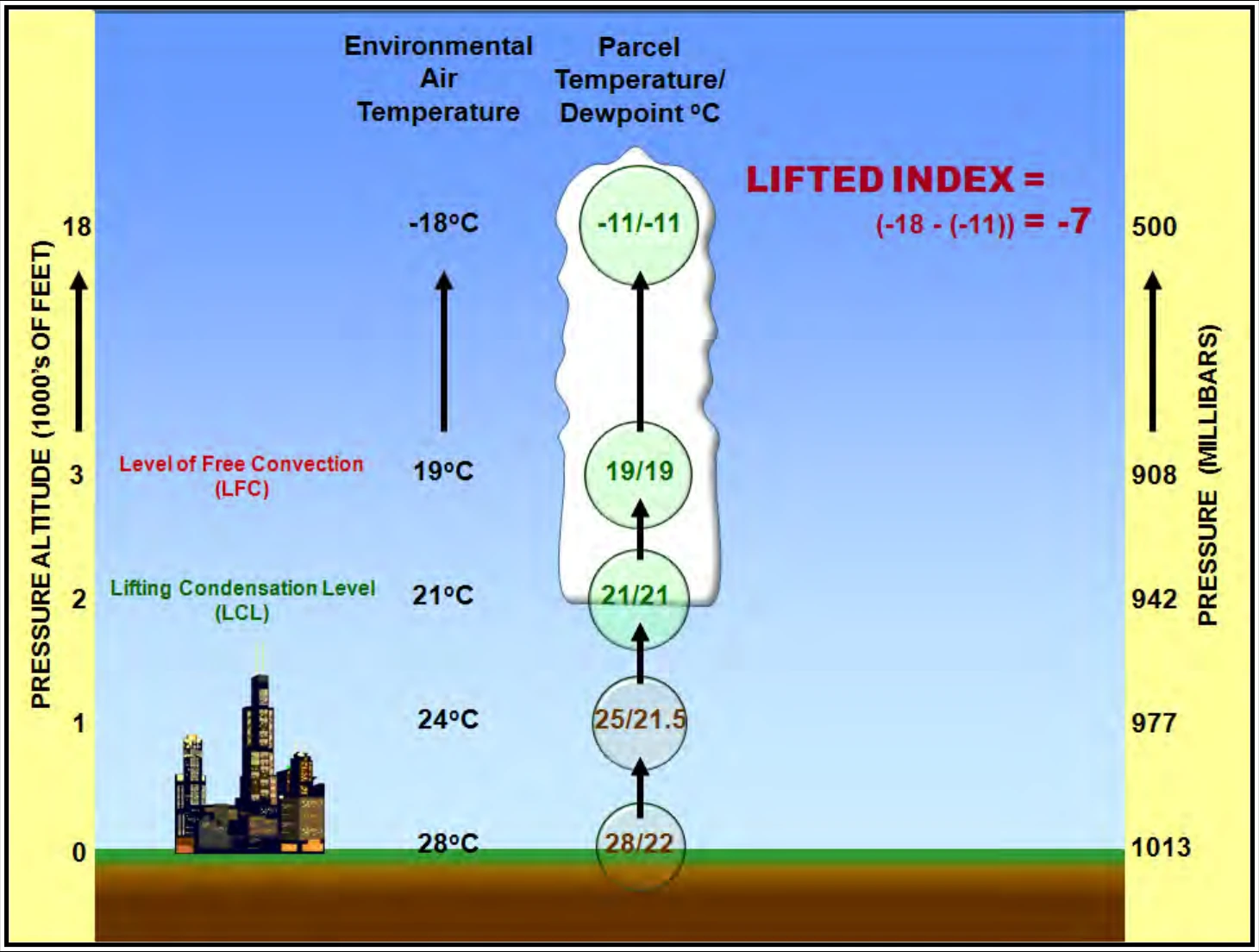
The LI (see Figure 13-9) is the temperature difference between an air parcel (usually at the surface) lifted adiabatically (see Chapter 12) and the temperature of the environment at a given pressure (usually 500 mb) in the atmosphere. A positive value indicates a stable column of air (at the respective pressure), a negative value indicates an unstable column of air, and a value of zero indicates a neutrally stable column of air. The larger the positive (negative) LI value, the more stable (unstable) the column of air.
LI is generally used in thunderstorm forecasting; however, CAPE is generally considered a superior measurement of instability. However, LI is easier to determine without using a computer.
13.5.2 Convective Available Potential Energy (CAPE)
CAPE is the maximum amount of energy available to an ascending air parcel for convection. CAPE is represented on a sounding by the area enclosed between the environmental temperature profile and the path of a rising air parcel over the layer, wherein the latter is warmer than the former. Units are joules per kilogram (J/kg) of air. Any value greater than 0 J/kg indicates instability and the possibility of thunderstorms.
CAPE is directly related to the maximum potential vertical speed within an updraft; thus, higher values indicate the potential for stronger updrafts. Observed values in thunderstorm environments often exceed 1,000 J/kg and in extreme cases may exceed 5,000 J/kg.
13.6 Convection
Convection is generally described as the transport of heat and moisture by the movement of a fluid. In meteorology, the term is used specifically to describe vertical transport of heat and moisture in the atmosphere, especially by updrafts and downdrafts in an unstable atmosphere. The terms “convection” and “thunderstorms” often are used interchangeably, although thunderstorms are only one form of convection. Cumulonimbus clouds, towering cumulus clouds, and altocumulus clouds all are visible forms of convection. However, convection is not always made visible by clouds. Convection occurring without cloud formation is called dry convection, while the visible convection processes referred to above are forms of moist convection.
13.6.1 Surface-Based Convection
Surface-based convection occurs within a surface-based layer (i.e., a layer in which the lowest portion is based at or very near the Earth’s surface) and is primarily generated by the daily heating of the surface of the Earth by the energy from the Sun.
13.6.2 Elevated Convection
Elevated convection occurs within an elevated layer (i.e., a layer in which the lowest portion is based above the Earth’s surface). Elevated convection often occurs when air near the ground is relatively cool and stable (e.g., during periods of isentropic lift, when an unstable layer of air is present aloft, etc.). In cases of elevated convection, stability indices based on near-surface measurements (such as the LI) will typically underestimate the amount of instability present. Severe weather is possible from elevated convection but is less likely than with surface-based convection.
13.6.3 Level of Free Convection (LFC)
The LFC is the level at which a parcel of saturated air becomes warmer than the surrounding air and begins to rise freely. This occurs most readily in a conditionally unstable atmosphere.
13.6.4 Popcorn Convection
Popcorn convection is a term often used for showers and thunderstorms that form on a scattered basis with little or no apparent organization, usually during the afternoon in response to diurnal heating. Individual thunderstorms are sometimes referred to as air mass thunderstorms. They are small, short-lived, very rarely severe, and they almost always dissipate near or just after sunset.
13.7 Summary
Atmospheric stability influences weather by affecting the vertical motion of air. Stable air suppresses vertical motion while unstable air enhances it.