Chapter 16
Mountain Weather
16.2.3 Vertically Propagating Mountain Waves
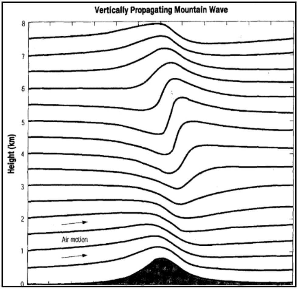
Figure 16-5 shows a schematic of a vertically propagating mountain wave. This feature is essentially a standing gravity wave whose energy propagates vertically. For this class of wave, nothing is preventing vertical propagation, such as strong wind shear or neutrally stable atmospheric layers. The mere fact that a wave has developed in air moving over a mountain (or other barrier) does not in itself indicate problems for an aircraft operating in the vicinity. The potential for hazard is a function of the strength of the wave and whether or not an area of the wave “breaks” into turbulent motions that, in the extreme, can lead to structural damage or failure of an aircraft component.
With this type of wave feature, air that is moving nearly perpendicular to the barrier is deflected upward and accelerated as it passes over the crests and down the lee slopes of the terrain. Notice in Figure 16-5 that the standing wave has developed vertically above the mountain crest and that the resulting wave tilts upwind with height. This vertical propagation of the wave means that the effects of the mountain range can be felt at heights significantly above the actual altitude of the peaks (at times reaching in excess of 60,000 ft). As a result, aircraft flying at virtually any altitude may have to deal with significant turbulence and wave-induced altitude excursions. In fact, the amplitude of this type of wave actually increases with height above the mountain (in the absence of atmospheric features, such as strong inversions or shear layers that would tend to partially reflect or absorb the upward-moving wave energy). This amplification is a consequence of the normal decrease in air density with altitude.
The amplitude of the wave will be larger, for the same upstream conditions, the higher the elevation of the mountain range above the surrounding terrain. Although even very modest terrain relief can cause appreciable wave activity under the proper conditions. Wave amplitude also will tend to be larger for stronger cross-mountain wind components at mountaintop level. However, the actual amplitude depends on complex relationships between upstream atmospheric wind and temperature profiles and the height and shape of the particular mountain range. Stronger flow across the mountain leads to a deeper wave, given the same atmospheric stability. However, the greater the background stability, the shallower the resulting wave, at fixed-wind speed.
As previously noted, the primary concern for pilots with this type of feature is that the vertical motions of the air moving through the wave may become strong enough to “break” into turbulence.
What is meant by “wave breaking”? Looking again at the streamlines that show the airflow in Figure 16-5, it shows that high above the ridge there is a region of updraft. With a wave of modest amplitude (in which the vertical displacement of air moving through the wave is relatively limited), an aircraft flying through this region would likely experience appreciable “wave action,” with altitude and/or airspeed fluctuations, but little turbulence. However, with sufficient amplitude, the wave breaks, and localized updrafts and downdrafts occur. The consequences for a pilot flying through this region include airspeed and altitude deviations and the possible sudden onset of severe or extreme turbulence. This type of turbulence occurs typically between 20,000 ft and 39,000 ft MSL and is, therefore, primarily of importance to turboprop and jet aircraft at cruise as they approach and overfly the mountain range.
(Source: Durran and Klemp, 1983)4
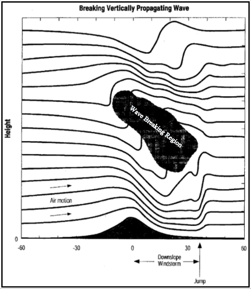
Often accompanying these high-altitude effects is the occurrence of very strong surface winds that result from the wave breaking aloft. In this case, strong downslope winds on the lee slopes can reach 100 kt gusts, creating a low-level turbulence hazard for all aircraft. Further, these extremely strong low-level winds often abruptly terminate in a “jump” located some distance down the lee slope or well to the lee of the mountains themselves. These features are indicated schematically in Figure 16-6. The jump region is frequently an area of extreme turbulence extending to 10,000 ft or more above the surface. The area of the jump is sometimes marked by a line of ragged rotor clouds exhibiting very turbulent motion. Downwind of the jump, turbulence decreases in intensity but still may be quite strong.
(Source: Durran and Klemp, 1983)5
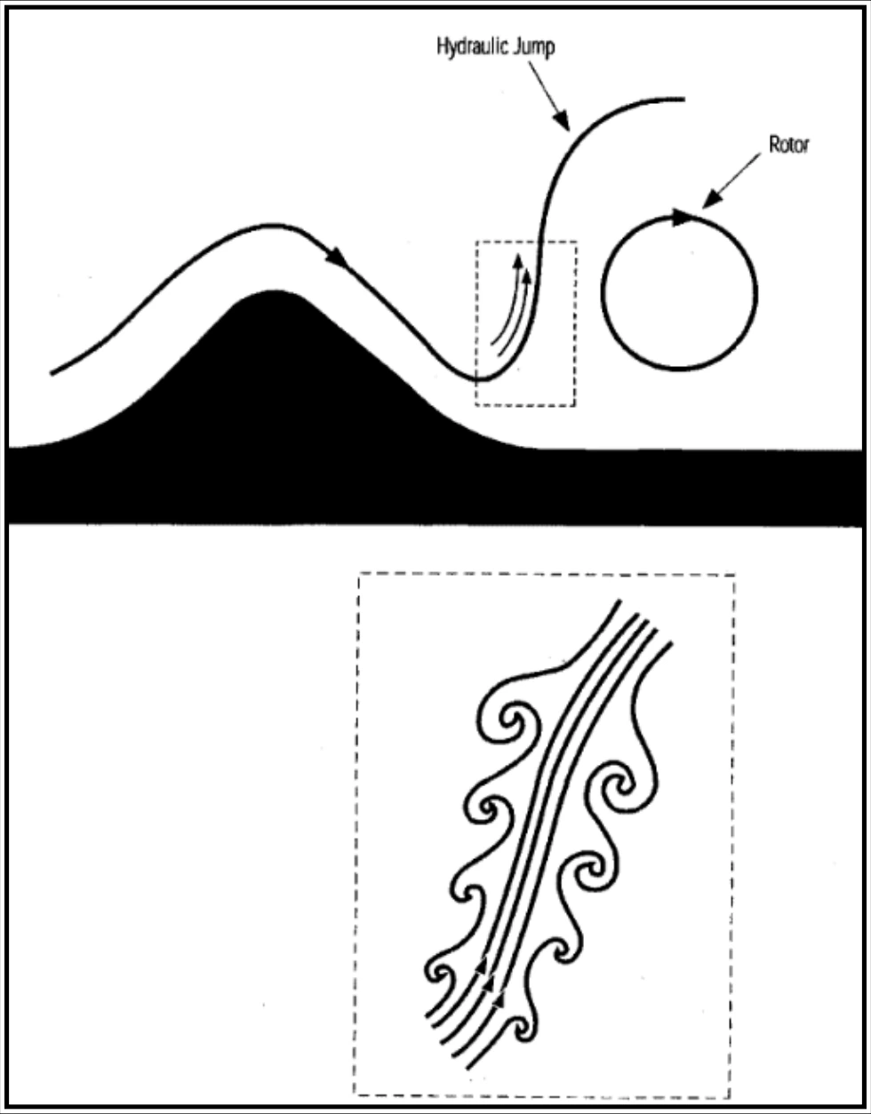
Figure 16-7 shows a schematic of the jump feature, with a pronounced wave and associated strong shear layer. The shear layer (shown in the inset) is a source of the turbulence found with the jump.
16.2.4 Trapped Lee Waves
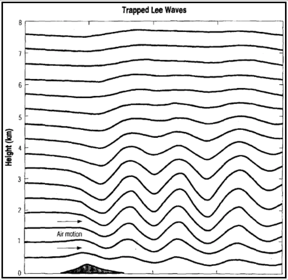
In the preceding section, an important type of mountain wave that propagates (i.e., transports its energy) vertically was discussed. Next, consider a second type of mountain wave, often manifested by a train of Altocumulus Standing Lenticular (ACSL) clouds extending far downwind of the mountain (although trapped lee waves frequently occur without clouds). These waves are of concern for takeoff and landing operations and en route flight below FL250. The associated lenticular (lens- or airfoil-shaped) clouds may appear turbulent or smooth and, depending on the moisture stratification upwind of the mountain, multilayered. They are evident as relatively straight lines or bands of clouds (with clear spaces between), parallel to the mountain range, but downstream from it.
The waves that produce these cloud features often are referred to as “trapped lee waves,” because the wave energy is confined below a certain altitude. The mechanism confining this energy is strong wind shear above ridge level. Trapped lee waves are most likely to occur when the wind crosses a narrow mountain range, with a layer close to ridge level and upstream of the mountain that has strongly increasing wind speed with height and high stability, capped by a layer of strong flow and low stability.
Figure 16-8 depicts a trapped lee wave. Notice that this type of wave extends downwind from the mountain, does not develop to a high altitude, and has no upstream tilt, in contrast to the vertically propagating wave in Figure 16-5.