
Chapter 16
Mountain Weather
(Source: Durran and Klemp, 1983)6
This class of wave presents less turbulence hazard at high altitude than do breaking vertically propagating waves, because the wave amplitude decreases with height within the “trapping layer,” typically based within a few thousand feet of the ridge crest. As a result, these waves do not extend to as great an altitude. An exception to this rule is when the atmospheric structure permits only partial trapping. This commonly occurs because the layer of wind shear that is instrumental in the trapping is weaker or shallower than necessary to do the job completely.
However, at lower altitudes, trapped lee waves can create strong turbulence encounters for aircraft. Below lenticular clouds, the wind can be quite variable and gusty, although usually not extremely strong. The gusty winds can extend from the surface up to the base of the clouds, particularly during daylight hours of spring and summer when the sky is otherwise mostly cloud-free.
Cloud bases associated with trapped lee waves are typically one to several thousand feet above ridge level, and PIREPs in the vicinity frequently indicate moderate-to-severe turbulence beneath the clouds. The turbulence associated with trapped lee waves is related to the large horizontal and vertical wind shears below cloud level.
With this type of wave, there is frequently a strong shear layer near cloud base immediately to the lee of the mountain range. This separates a turbulent wake region below mountaintop level from the faster-moving, cloud-bearing air above. In the cloud layer itself, conditions typically range from turbulent near cloud base to smooth near cloud top. The clouds themselves give some indication of the degree of turbulence within them; smooth, laminar-looking edges and tops are associated with little or no turbulence, while a lumpy, non-uniform appearance and a visual impression of rolling motion about an axis parallel to the cloud is indicative of turbulence.
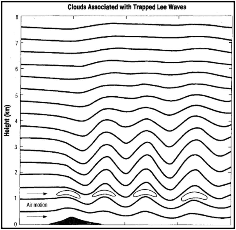
Superimposed on the smaller-scale turbulent motions that may be present are larger-scale updraft and downdraft motions that are a part of the wave. Vertical shear of the horizontal wind is locally enhanced at the crests and troughs of the wave as a result of vertical transport (by the wave) of strong winds, leading to shear-induced turbulence. Figure 16-9 shows lenticular clouds associated with a trapped lee wave. Note the laminar appearance of the flow within the cloud that has developed from expansional cooling and condensation of water vapor in the upward-moving portion of the wave.
The rolling motions in these clouds associated with a trapped lee wave are repetitive downstream, each cloud band corresponding with a wave crest.
(Source: Durran and Klemp, 1983)7
16.2.5 Persistent Horizontal Roll Vortices (Rotors)
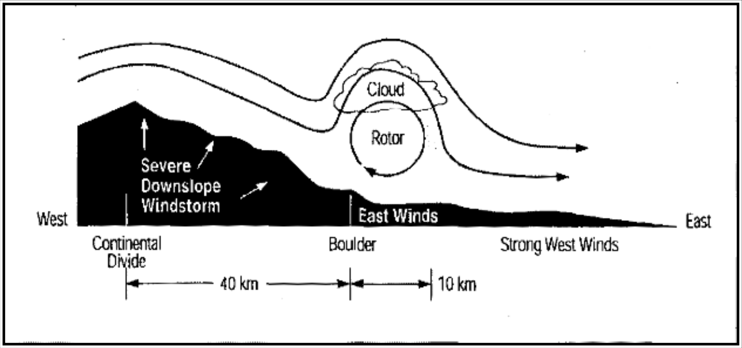
When mountain waves are present, it is quite common for a rotor zone to develop near or below ridge level on the downwind side of the mountain, under a wave crest and associated lenticular cloud (if sufficient moisture is present). This is an area of potentially severe-to-extreme wind shear and turbulence.
Figure 16-10 shows a schematic of the wind flow associated with this feature. As illustrated in this figure, rotors typically mark the downwind terminus of a downslope windstorm. When this is the case, the rotor is really part of the “jump” discussed earlier. Although strong rotation is typically present within the rotor zone and associated cloud, a pilot in a moving aircraft may not be able to detect such motion visually until the aircraft is quite close to the vortex. In fact, from a distance, a rotor cloud may look like a rather innocuous cumulus cloud; however, the downwind side of the rotor cloud will typically be rounded in the direction of rotation of the rotor, with cloud tags or streamers at the bottom of the cloud mass.
The latter features appear to be rapidly forming and dissipating, thereby giving some sense of rotation within the cloud.
(Source: Bedard, 1993)8
Because of their potential for causing turbulence and loss of aircraft control, rotor zones should be avoided. Rotor zones are of concern not only because of the likelihood of strong turbulence in their vicinity, particularly on the upwind side of the rotor, but also because of the potential for rolling moments that could exceed the roll authority of the aircraft or otherwise lead to loss of control. Rotors are especially dangerous at low altitudes, particularly during takeoff and landing as the aircraft is slowed and in a relatively high-drag configuration.