Chapter 20
Icing
Mixed ice is a mixture of clear ice and rime ice. It forms as an airplane that collects both rime and clear ice due to small-scale (tens of kilometers or less) variations in liquid water content, temperature, and droplet sizes. Mixed ice appears as layers of relatively clear and opaque ice when examined from the side.
Mixed icing poses a similar hazard to an aircraft as clear ice. It may form horns or other shapes that disrupt airflow and cause handling and performance problems. It can spread over more of the airframe’s surface and is more difficult to remove than rime ice. It can also spread over a portion of airfoil not protected by anti-icing or deicing equipment. Ice forming farther aft causes flow separation and turbulence over a large area of the airfoil, which decreases the ability of the airfoil to keep the aircraft in flight.
20.3.4 Icing Factors
Structural icing is determined by many factors. The meteorological quantities most closely related to icing type and severity are, in order of importance: SLWC, temperature, and droplet size. However, aircraft type/design and airspeed are also important factors.
SLWC is important in determining how much water is available for icing. The highest quantities can be found in cumuliform clouds, with the lowest quantities found in stratiform clouds. However, in most icing cases, SLWC is low.
Icing potential is very temperature dependent. For icing to occur, the outside air temperature (OAT) must be below 0°C. As clouds get colder, SLWC decreases until only ice crystals remain. Thus, almost all icing tends to occur in the temperature interval between 0°C and -20°C, with about half of all reports occurring between -8°C and -12°C. In altitude terms, the peak of occurrence is near 10,000 ft, with approximately half of incidents occurring between 5,000–13,000 ft. The only physical cold limit to icing is at -40°C because liquid droplets freeze without nuclei present.
In general, rime ice tends to occur at temperatures colder than -15°C, clear ice when the temperature is warmer than -10°C, and mixed ice at temperatures in between. This is only general guidance. The type of ice will vary depending on the liquid water content, droplet size, and aircraft-specific variables.
An airframe can remain cold (temperature below 0°C) in a warm (temperature above 0°C) atmosphere if it is cold-soaked. For example, if an aircraft has been flying in a cold environment but then descends into warmer temperatures, the airframe does not heat up immediately to the air temperature. For some aircraft, the airframe can remain colder than 0°C for some time, even after landing. Aircraft with fuel tanks mounted flush to the airframe are particularly susceptible to icing, even in an environment where the air temperature is slightly above 0°C. Because these characteristics vary from airframe to airframe, it is important for pilots to be aware of the limitations of their aircraft.
Droplet size can influence icing, but it is not as important as SLWC and temperature, unless the droplets are larger than cloud droplets in size (e.g., freezing drizzle and freezing rain). Droplet size affects the collection of drops by the airframe. Small droplets tend to impact the airfoil near the plane’s leading edge. Larger drops, including freezing rain and freezing drizzle, can cross the streamlines and impact farther back.
Aircraft airspeed is an important non-meteorological factor that determines icing type and severity. The rate of supercooled water droplet impact increases with airspeed, which acts to increase ice accumulation, but this is counteracted by the increase of airframe skin surface heating due to friction. Typically, airframe icing is negligible at speeds above 575 kt.
Aircraft type and design are also important factors. Because these characteristics vary, it is important for pilots to be aware of the limitations of their aircraft.
Commercial jet aircraft are generally less vulnerable to structural icing than light turboprop aircraft. This is due to their rapid airspeed, powerful deicing equipment, and tendency to cruise at higher altitudes where temperatures are typically too cold for icing. Conversely, light turboprop aircraft are more susceptible to icing because they typically fly at lower altitudes where icing is more common and at slower speeds.
20.3.5 Icing in Stratiform Clouds
Icing in middle and low-level stratiform clouds is confined, on the average, to a layer between 3,000-ft and 4,000-ft thick. Thus, a change in altitude of only a few thousand feet may take the aircraft out of icing conditions, even if it remains in clouds. Icing intensity generally ranges from a trace to light, with the maximum values occurring in the cloud’s upper portions. Both rime and mixed icing are found in stratiform clouds. The main hazard lies in the great horizontal extent of stratiform clouds layers. High-level stratiform clouds (i.e., at temperatures colder than -20°C) are composed mostly of ice crystals and produce little icing.
20.3.6 Icing in Cumuliform Clouds
The icing layer in cumuliform clouds is horizontally smaller but vertically greater than in stratiform clouds. Icing is more variable in cumuliform clouds because many of the factors conducive to icing depend on the particular cloud’s stage of development. Icing intensities may range from a trace in small cumulus to severe in a large, towering cumulus or cumulonimbus. Although icing occurs at all levels above the freezing level in a building cumuliform cloud, it is most intense in the upper portion of the cloud where the updraft is concentrated and SLDs are plentiful. Icing can extend to great heights in towering cumulus and cumulonimbus where strong updrafts allow SLDs to exist at temperatures as cold as -40°C. Icing in a cumuliform cloud is usually clear or mixed with rime in the upper levels.
20.3.7 Icing with Fronts
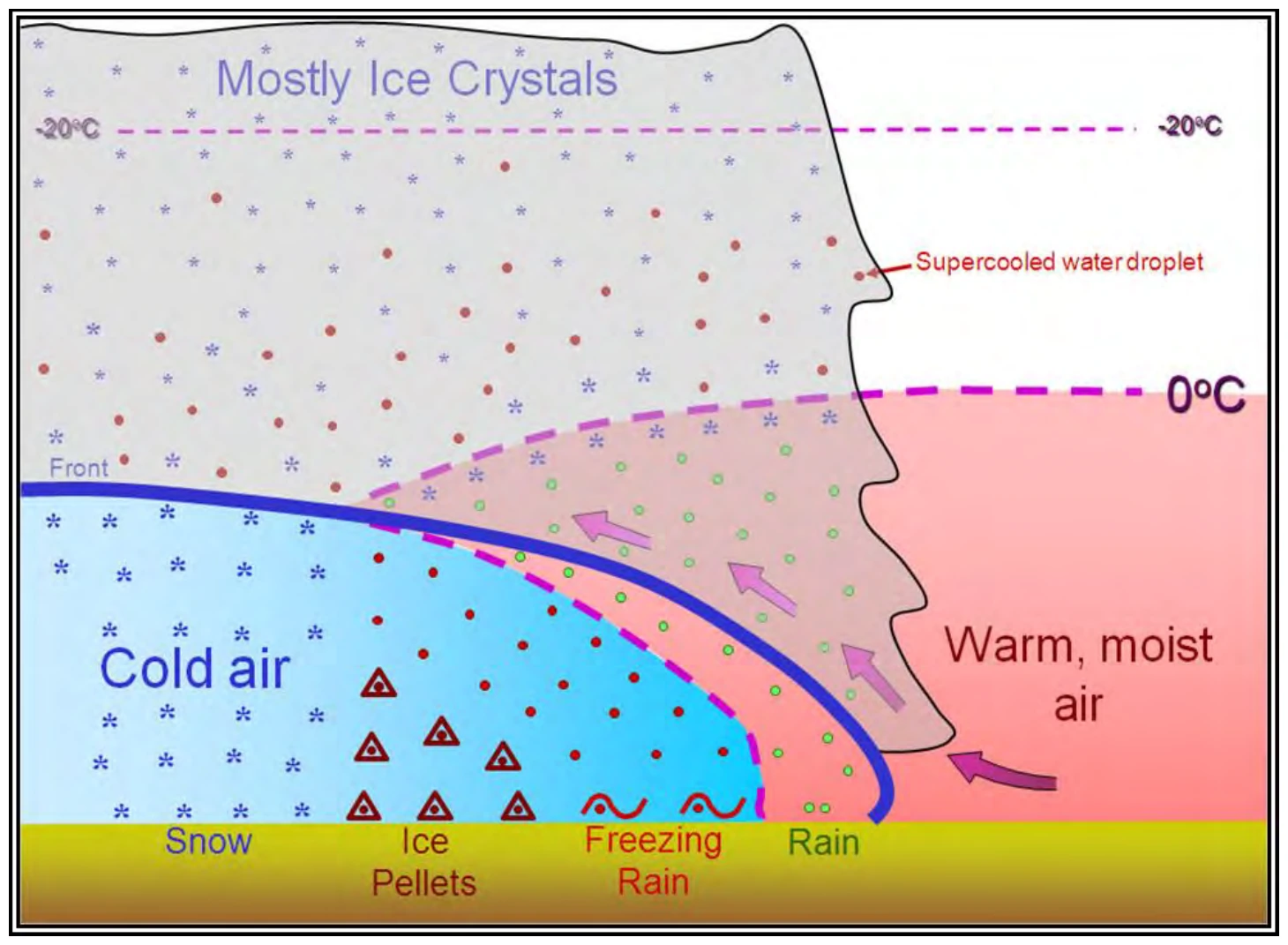
Most icing reports occur in the vicinity of fronts. This icing can occur both above and below the front (see Figure 20-1).
For significant icing to occur above the front, the warm air must be lifted and cooled to saturation at temperatures below zero, making it contain supercooled water droplets. The supercooled water droplets freeze on impact with an aircraft. If the warm air is unstable, icing may be sporadic; if it is stable, icing may be continuous over an extended area. A line of showers or thunderstorms along a cold front may produce icing but only in a comparatively narrow band along the front.