
Chapter 24
Observations
METAR KOKC 011955Z AUTO 22015G25KT 180V250 3/4SM R17L/2600FT +TSRA BR OVC010CB
18/16 A2992 RMK AO2 TSB25 TS OHD MOV E SLP132
Present weather includes precipitation, obscurations, and other weather phenomena. The appropriate notations found in Table 24-3 are used to code present weather.
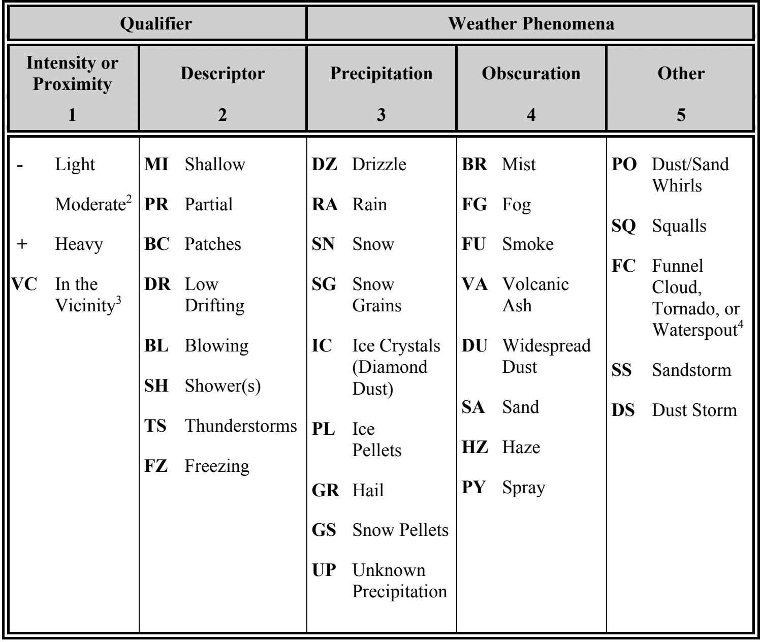
- The weather groups are constructed by considering columns 1 through 5 in Table 24-3 in sequence (i.e., intensity followed by description, followed by weather phenomena). For example, heavy rain shower(s) is coded as +SHRA.
- To denote moderate intensity, no entry or symbol is used.
- See text for vicinity definitions.
- Tornadoes and waterspouts are coded as +FC.
Separate groups are used for each type of present weather. Each group is separated from the other by a space. METARs/SPECIs contain no more than three present weather groups.
When more than one type of present weather is reported at the same time, present weather is reported in the following order:
- Tornadic activity (tornado, funnel cloud, or waterspout).
- Thunderstorm(s) (with and without associated precipitation).
- Present weather in order of decreasing dominance (i.e., the most dominant type reported first).
- Left to right in Table 24-3 (columns 1 through 5).
Qualifiers may be used in various combinations to describe weather phenomena. Present weather qualifiers fall into two categories:
- Intensity or proximity, and
- Descriptors.
24.4.3.8.1 Intensity Qualifier
The intensity qualifiers are light, moderate, and heavy. They are coded with precipitation types, except ice crystals (IC) and hail (GR), including those associated with a thunderstorm (TS) and those of a showery nature (SH). Tornadoes and waterspouts are coded as heavy (+FC). No intensity is ascribed to the obscurations of blowing dust (BLDU), blowing sand (BLSA), and blowing snow (BLSN). Only moderate or heavy intensity is ascribed to sandstorm (SS) and dust storm (DS).
When more than one form of precipitation is occurring at a time, or precipitation is occurring with an obscuration, the reported intensities are not cumulative. The reported intensity will not be greater than the intensity for each form of precipitation. For example, -FZRAPL is light freezing rain and light ice pellets, not light freezing rain and moderate ice pellets.
24.4.3.8.2 Proximity Qualifier
Weather phenomena occurring beyond the point of observation (between 5–10 SM) are coded as in the vicinity (VC). VC can be coded in combination with thunderstorm (TS), fog (FG), shower(s) (SH), well-developed dust/sand whirls (PO), blowing dust (BLDU), blowing sand (BLSA), blowing snow (BLSN), sandstorm (SS), and dust storm (DS). Intensity qualifiers are not coded in conjunction with VC.
For example, VCFG can be decoded as meaning some form of fog is between 5–10 SM of the point of observation. If VCSH is coded, showers are occurring between 5–10 SM of the point of observation.
Weather phenomena occurring at the point of observation (at the station) or in the vicinity of the point of observation are coded in the body of the report. Weather phenomena observed beyond 10 SM from the point of observation (at the station) is not coded in the body but may be coded in the remarks section.
24.4.3.8.3 Descriptor Qualifier
Descriptors are qualifiers that further amplify weather phenomena and are used in conjunction with some types of precipitation and obscurations. The descriptor qualifiers are shallow (MI), partial (PR), patches (BC), low drifting (DR), blowing (BL), shower(s) (SH), thunderstorm (TS), and freezing (FZ).
Only one descriptor is coded for each weather phenomena group (e.g., FZDZ).
The descriptors shallow (MI), partial (PR), and patches (BC) are only coded with fog (FG) (e.g., MIFG). Mist (BR) is not coded with any descriptor.