
Chapter 26
Advisories
Amendments to CONUS Non-Convective SIGMETs are not issued. Instead, a new SIGMET is issued using the next series number.
26.2.4.1.6 SIGMET (Non-Convective) Corrections—CONUS
Corrections to CONUS Non-Convective SIGMETs are issued as necessary. The corrected SIGMET is identified by a “COR” located at the end of the first line after the issuance UTC date/time.
26.2.4.2 Convective SIGMET
Convective SIGMETs are issued for the CONUS instead of SIGMETs for thunderstorms. Any Convective SIGMET implies severe or greater turbulence, severe icing, and LLWS.
Although the areas where the Convective SIGMETs apply may be shown graphically, such a graphical depiction, the Convective SIGMET polygon is a “snapshot” that outlines the area (or line) of thunderstorms at the issuance time of 55 minutes past each hour. During the valid time of the SIGMET, the area/line will move according to the movement vector given in the SIGMET. For fast-moving areas or lines, they will very likely end up outside the SIGMET polygon by the end of the hour. Slow-moving or stationary areas or lines will likely remain in or very close to the original polygon. For additional clarification, the movement “MOV FROM...” within the Convective SIGMET describes the current movement of the SIGMET area or line. In cases when cell movements are different within the area, the SIGMET will include an additional line that states “CELL MOV FROM.” Detailed information regarding the Convective SIGMET depiction should be compared to the textual version for storm movement, velocity, cloud tops, and several other important elements. Users should exercise caution as areas of convection and their associated polygons can change and should only be used for strategic planning.
26.2.4.2.1 Convective SIGMET Routine Issuance Criteria
A Convective SIGMET will be issued when any of the following conditions are occurring, or, in the judgment of the forecaster, are expected to occur:
- A line of thunderstorms at least 60 mi long with thunderstorms affecting at least 40 percent of its length.
- An area of active thunderstorms judged to have a significant impact on the safety of aircraft operations covering at least 40 percent of the area concerned and exhibiting a very strong radar reflectivity intensity or a significant satellite or lightning signature.
- Embedded or severe thunderstorm(s) expected to occur for more than 30 minutes during the valid period, regardless of the size of the area.
26.2.4.2.2 Convective SIGMET Special Issuance Criteria
A special Convective SIGMET may be issued when any of the following criteria are occurring or, in the judgment of the forecaster, are expected to occur for more than 30 minutes of the valid period:
- Tornado, hail greater than or equal to ¾ in (at the surface), or wind gusts greater than or equal to 50 kt (at the surface) are reported.
- Indications of rapidly changing conditions if, in the forecaster’s judgment, they are not sufficiently described in existing Convective SIGMETs.
Special issuance is not required for a valid Convective SIGMET.
26.2.4.2.3 Convective SIGMET Issuance Time and Valid Period
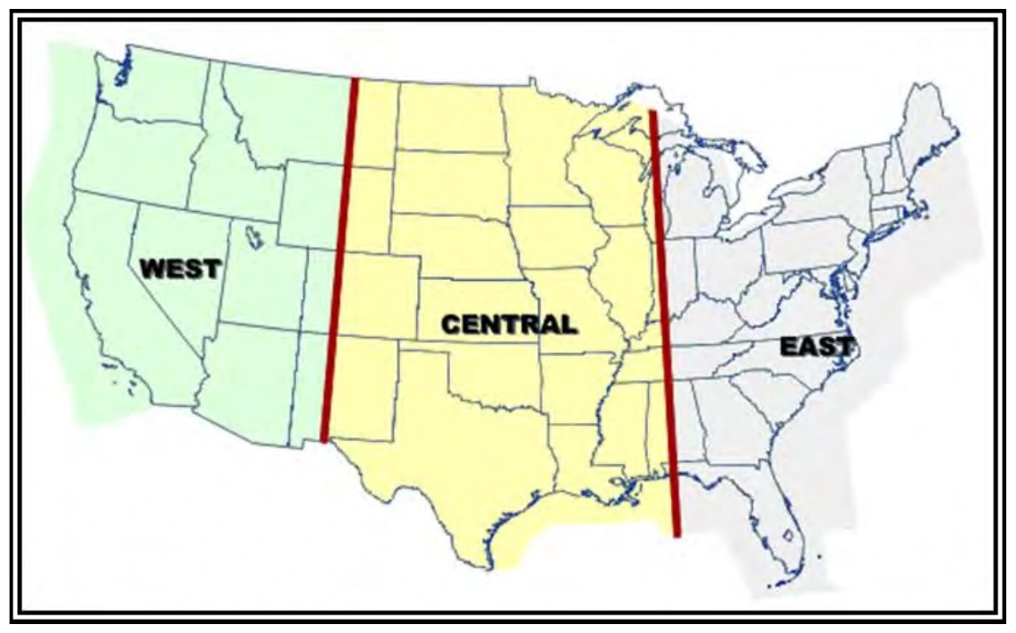
Convective SIGMET bulletins for the eastern, central, and western regions of the CONUS (see Figure 26-5) are issued on a scheduled basis, hourly at 55 minutes past the hour. Each bulletin contains all valid Convective SIGMETs within the region. Convective SIGMETs are valid for two hours or until superseded by the next hourly issuance. A Convective SIGMET bulletin must be transmitted each hour for each region. When conditions do not meet or are not expected to meet Convective SIGMET criteria within a region at the scheduled time of issuance, a “CONVECTIVE SIGMET...NONE” message is transmitted.
26.2.4.2.4 Convective SIGMET Format and Example
Each Convective SIGMET bulletin includes one or more individually numbered Convective SIGMETs for the region. The content and order of each bulletin is as follows:
- Convective SIGMET series number and region letter (E, W, or C).
- Valid ending time (UTC).
- List of states affected by the phenomena.
- Location of phenomena delineated by high-altitude VOR coordinates covering the affected area during the SIGMET valid time.
- Phenomena description (e.g., AREA SEV EMBD TS).
- Movement (e.g., MOV FROM 26030KT).
- Cloud top (e.g., TOPS ABV FL450).
- Remarks (e.g., TORNADOES...HAIL TO 2.5 IN...WIND GUSTS TO 70KT POSS).