
Chapter 26
Advisories
AIRMETs over Alaska and Hawaii are in text format. The hazard areas are described using well-known geographical areas. AIRMETs over Alaska are issued for three Alaska regions corresponding to Alaska area forecasts.
AIRMETs over Alaska are valid up to eight hours. AIRMETs over Hawaii are valid up to six hours. Unscheduled issuances contain an update number for easier identification.
There are three AIRMET categories: Sierra, Tango, and Zulu.
- AIRMET Sierra describes IFR conditions and/or extensive mountain obscurations.
- AIRMET Tango describes moderate turbulence, sustained surface winds of 30 kt or greater, and/or non-convective LLWS.
- AIRMET Zulu describes moderate icing and provides freezing level heights.
26.3.1.3 AIRMET Issuance Criteria
An AIRMET may be issued when any of the following weather phenomena are occurring or are expected to occur:
- Ceiling less than 1,000 ft and/or visibility less than 3 SM (IFR).
- Weather phenomena restricting the visibility including, but not limited to, precipitation (PCPN), smoke (FU), haze (HZ), mist (BR), fog (FG), and blowing snow (BS).
- Widespread mountain obscuration (MTN OBSCN).
- Weather phenomena causing the obscuration are included, but not limited to, clouds (CLDS), precipitation (PCPN), smoke (FU), haze (HZ), mist (BR), and fog (FG).
- Moderate turbulence (MOD TURB).
- Top and bottom of MOD TURB layer are specified.
- Sustained surface wind greater than 30 kt (STG SFC WND).
- Moderate icing (MOD ICE).
- Top and bottom of MOD ICE are specified.
- The range of freezing level altitudes is given when the bottom altitude of MOD ICE is the freezing level (FRZLVL).
- Areas with multiple freezing levels are specified.
- Range of freezing levels over the area is specified.
- Lowest freezing levels AGL at intervals of 4,000 ft MSL (or surface (SFC) as appropriate) are specified.
- Non-convective LLWS potential below 2,000 ft AGL (LLWS POTENTIAL).
26.3.2 AIRMET Standardization
All AIRMETs follow these standards:
- All heights or altitudes are referenced to above MSL, unless otherwise noted, and annotated using the height in hundreds of feet, consisting of three digits (e.g., 040). For heights at or above 18,000 ft, the level is preceded by “FL” to represent flight levels (e.g., FL180).
- Messages are prepared in abbreviated plain language using contractions from Order JO 7340.2. A limited number of non-abbreviated words, geographical names, and numerical values of a self-explanatory nature may also be used.
- Weather and obstructions to visibility are described using the weather abbreviations for surface weather observations (METAR/SPECI). Refer to Federal Meteorological Handbook No. 1, Surface Weather Observations and Reports, or Section 24.3 of this handbook.
26.3.3 AIRMET Issuance Times and Valid Periods
AIRMETs are issued following the schedule listed in Table 26-4. AIRMETs are issued four times a day except for those in Alaska, which are issued three times a day. Unscheduled AIRMETs are issued when conditions are occurring or expected to occur but were not forecast.
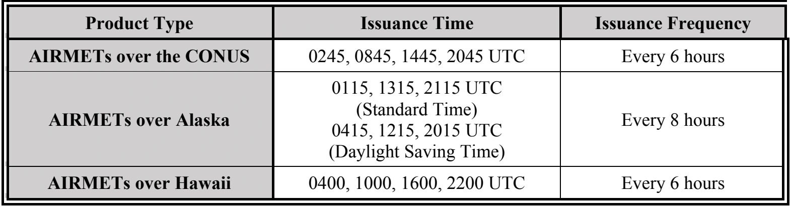
AIRMETs are valid for six hours except for those in Alaska, which are valid for eight hours. The valid period of an AIRMET message cannot exceed the valid time of the AIRMET bulletin. However, note that each AIRMET contains remarks concerning the continuance of the phenomenon during the six hours following the AIRMET ending time. Also, AIRMET bulletins can contain a separate outlook when conditions meeting AIRMET criteria are expected to occur during the six-hour period (eight-hour for Alaska) after the valid time of the AIRMET bulletin.
26.3.4 AIRMET Formats and Examples
The AWC’s website provides several options to display AIRMETs over the CONUS. There is an interactive display, as well as snapshots that may be viewed as static (single), combined, and looped images using the tools provided on the website.
An AIRMET message for Alaska and Hawaii includes the following information as appropriate and in the order indicated:
- Reference to appropriate active SIGMETs affecting the area at the time of AIRMET issuance (e.g., SEE SIGMET BRAVO SERIES).
- Beginning time of the AIRMET phenomenon if different from the AIRMET beginning valid time.
- AIRMET name (SIERRA, TANGO, or ZULU), update number, weather phenomenon, and ending valid time. (Note: The AIRMET number is reset to 1 after 0000 UTC each day.)
- AIRMET Sierra describes IFR conditions and/or extensive mountain obscurations. Hawaii AIRMETs for mountain obscuration may be issued for an area less than 3,000 mi2.
- AIRMET Tango describes moderate turbulence, sustained surface winds of 30 kt or greater, and non-convective LLWS.
- AIRMET Zulu describes moderate icing and provides freezing-level heights.
- Fixed geographic locations (Alaska and Hawaii; see Figure 27-3).
- Description of phenomenon for the AIRMET issuance.
- Vertical extent (bases and tops), as appropriate.
- Ending time of phenomenon if different from the AIRMET ending time.
- For Alaska AIRMETs: Intensity change remarks (INTSF, WKN, IMPR, or NC) concerning the continuance of the phenomenon following the valid period.
- For Hawaii AIRMETs: A separate AIRMET outlook is included in the AIRMET bulletin when conditions meeting AIRMET criteria are expected to occur during the six-hour period after the valid time of the AIRMET bulletin.
26.3.4.1 Example of AIRMET Sierra Issued for the Southeast Alaska Area
WAAK47 PAWU 241324
WA7O
JNUS WA 241315
AIRMET SIERRA FOR IFR AND MT OBSC VALID UNTIL 242115
.
LYNN CANAL AND GLACIER BAY JB
MTS OBSC BY CLDS/ISOL PCPN. NC.
.
CNTRL SE AK JC
MTS OCNL OBSC IN CLDS. NC.
.
SRN SE AK JD
PAWG-PAKT LN W OCNL CIGS BLW 010/VIS BLW 3SM BR. IMPR.
.
SRN SE AK JD
MTS OCNL OBSC IN CLDS. NC.
.
ERN GLF CST JE
OCNL CIGS BLW 010/VIS BLW 3SM BR/-RA BR. DTRT.
.
ERN GLF CST JE
MTS OBSC IN CLDS/ISOL PCPN. DTRT.
.
SE AK CSTL WTRS JF
MTS OCNL OBSC IN CLDS. NC.
.
=JNUT WA 241315
AIRMET TANGO FOR TURB/STG SFC WINDS VALID UNTIL 242115
.
ERN GLF CST JE
OFSHR ICY BAY W SUSTAINED SFC WND 30 KTS
OR GTR. SPRDG E. INTSF.
.
=JNUZ WA 241315
AIRMET ZULU FOR ICING VALID UNTIL 242115
.
ERN GLF CST JE
16Z TO 19Z ALG CST W ICY BAY OCNL MOD ICEIC 080-160.
FZLVL 045 EXC 015 INLAND. WKN.