
Chapter 26
Advisories
The VAA is advisory information on volcanic ash cloud issued in abbreviated plain language, using approved ICAO abbreviations and numerical values of self-explanatory nature.
A graphical (e.g., chart) version of the VAA is also produced and is sometimes referred to as “VAG.” The VAG contains the same information as in the VAA but in a four-panel chart format.
26.5.1 Volcanic Ash Advisory Center (VAAC)
A VAAC is a meteorological office designated by an ICAO regional air navigation agreement to provide advisory volcanic ash information to MWOs, WAFCs, area control centers, flight information centers, and international operational meteorological (OPMET) data banks regarding the lateral and vertical extent and forecast movement of volcanic ash in the atmosphere following a volcanic eruption. There are nine VAACs worldwide (see Figure 26-10). The duties of a VAAC include:
- Monitoring relevant geostationary and polar-orbiting satellite data to detect the existence and extent of volcanic ash in the atmosphere in the area concerned;
- Activating the volcanic ash numerical trajectory/dispersion model in order to forecast the movement of any ash cloud that has been detected or reported; and
- Issuing advisory information regarding the extent and forecast movement of the volcanic ash cloud.
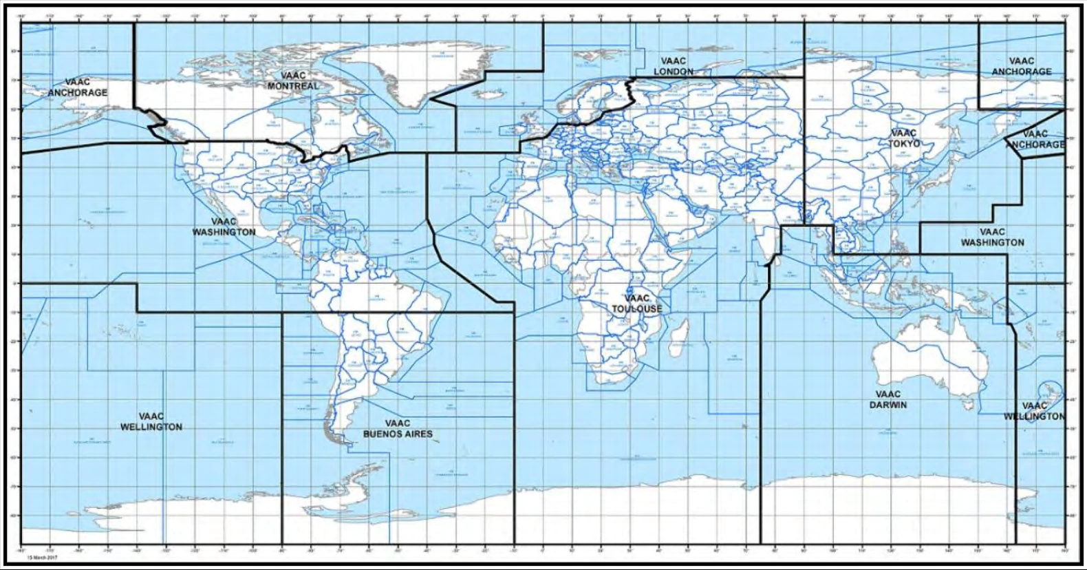
Areas of responsibility for VAACs include Anchorage, Montreal, Washington, Wellington (New Zealand), Buenos Aires (Argentina), London, Toulouse (France), Tokyo, and Darwin.
The United States has two VAACs with responsibilities defined in ICAO Annex 3, Meteorological Service for International Air Navigation. The Washington VAAC is jointly managed by the NESDIS SAB and the NWS NCO. The Anchorage VAAC is managed by the NWS AAWU.
The Washington VAAC areas of responsibility are:
- FIRs in the CONUS and adjacent coastal waters.
- The Oakland Oceanic FIR over the Pacific Ocean.
- The New York FIR over the western Atlantic Ocean.
- FIRs over and adjacent to the Caribbean and Central and South America north of 10° S latitude.
The Anchorage VAAC areas of responsibility are:
- The Anchorage FIR.
- Russian FIRs north of 60°N latitude and east of 150°E longitude.
26.5.1.1 VAA Issuance
Each VAAC issues VAAs to provide guidance to MWOs for SIGMETs involving volcanic ash.
VAAs are issued as necessary, but at least every six hours until such time as the volcanic ash cloud is no longer identifiable from satellite data, no further reports of volcanic ash are received from the area, and no further eruptions of the volcano are reported.
VAAs in both text and graphical format are available from the websites of the VAACs as well as other weather information sources.
26.5.1.2 VAA Format
The VAA format conforms to the template included in ICAO Annex 3, Table A2-1, Template for Advisory Message for Volcanic Ash.
26.5.1.3 VAA Text Example
FVAK21 PAWU 190615
VOLCANIC ASH ADVISORY
ISSUED: 20030419/0615Z
VAAC: ANCHORAGE
VOLCANO: CHIKURACHKI, 900-36
LOCATION: N5019 E15527
AREA: KAMCHATKA NORTHERN KURIL ISLANDS
SUMMIT ELEVATION: 7674 FT (2339 M)
ADVISORY NUMBER: 2003-02
INFORMATION SOURCE: SATELLITE
AVIATION COLOR CODE: NOT GIVEN
ERUPTION DETAILS: NEW ERUPTION OCCURRED APPROX 190500 UTC.
HEIGHT IS ESTIMATED AT FL300. ESTIMATE IS BASED ON OBSERVED AND MODEL WINDS.
MOVEMENT APPEARS TO BE E AT 75 KTS.
OBS ASH DATA/TIME: 19/0500Z
OBS ASH CLOUD: VA EXTENDS FM NEAR VOLCANO EWD TO N50 E160.
FCST ASH CLOUD +6HR: 30NM EITHER SIDE OF LN FM NIPPI N49 E159 - N50 E175.
FCST ASH CLOUD +12HR: 30NM EITHER SIDE OF LN FM N50 E168 - N50 E180.
FCST ASH CLOUD +18HR: 30NM EITHER SIDE OF LN FM N51 E175 - N50 E185.
NEXT ADVISORY: 20030419/1500Z
REMARKS: UPDATES AS SOON AS INFO BECOMES AVAILABLE.