Chapter 10
IFR Flight
AIRMET IFR...OK TX LA AR MS AL FL TS IMPLY SEV OR GTR TURB SEV ICE LLWS AND IFR CONDS.
NON MSL HGHTS DENOTED BY AGL OR CIG.
A recheck of NOTAMs for Gulfport confirms that the localizer to runway 32 is out of service until further notice and runway 18/36 is closed. If runway 6 is planned for the departure, confirm that the climb restriction for the departure can be met.
GPT 12/006 GPT LOC OS UFN
GPT 12/008 GPT MIRL RWY 18/36 OS UFN
Since the weather is substantially better to the east, Pensacola Regional Airport is a good alternate with current conditions and a forecast of marginal VFR.
METAR KPNS 111150Z 21010Z 3SM BKN014 OVC025 09/03 A2973
TAF KPNS 111152Z 111212 22010KT 3 SM BR OVC020 BECMG 1317 4 SM BR OVC025
FM1700 23010KT 4SM –RA OVC030
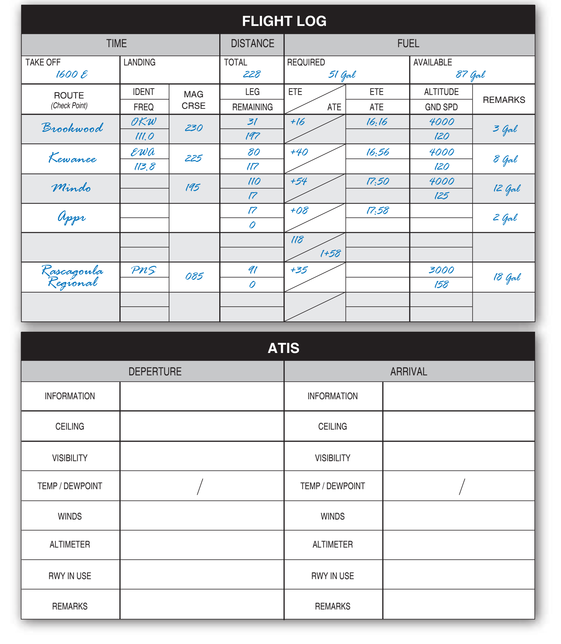
FM 0400 25014KT 5SM OVC050 TEMPO1612 P6SM OVC080 If weather minimums are below a pilot’s personal minimums, a delay in departure to wait for improved conditions is a good decision. This time can be used to complete the navigation log, which is the next step in planning an IFR flight. [Figure 10-19]
Use the POH/AFM to compute a true airspeed, cruise power setting, and fuel burn based on the forecast temperatures aloft and cruising pressure altitude. Also, compute weight-and-balance information and determine takeoff and landing distances. There will be a crosswind if weather conditions require a straight-in landing on runway 14 at GPT. Therefore, compute the landing distance assuming a 10-knot crosswind and determine if the runway length is adequate to allow landing. Determine the estimated flight time and fuel burn using the winds aloft forecast and considering Pensacola Regional Airport as an alternate airport. With full tanks, the flight can be made nonstop with adequate fuel for flight to the destination, alternate, and the reserve requirement.
Next, check the surface analysis chart, which shows where the pressure systems are found. The weather depiction chart shows areas of IFR conditions and can be used to find areas of improving conditions. These charts provide information a pilot needs should a diversion to VFR conditions be required. For this flight, the radar depicts precipitation along the route, and the latest satellite photo confirms what the weather depiction chart showed.
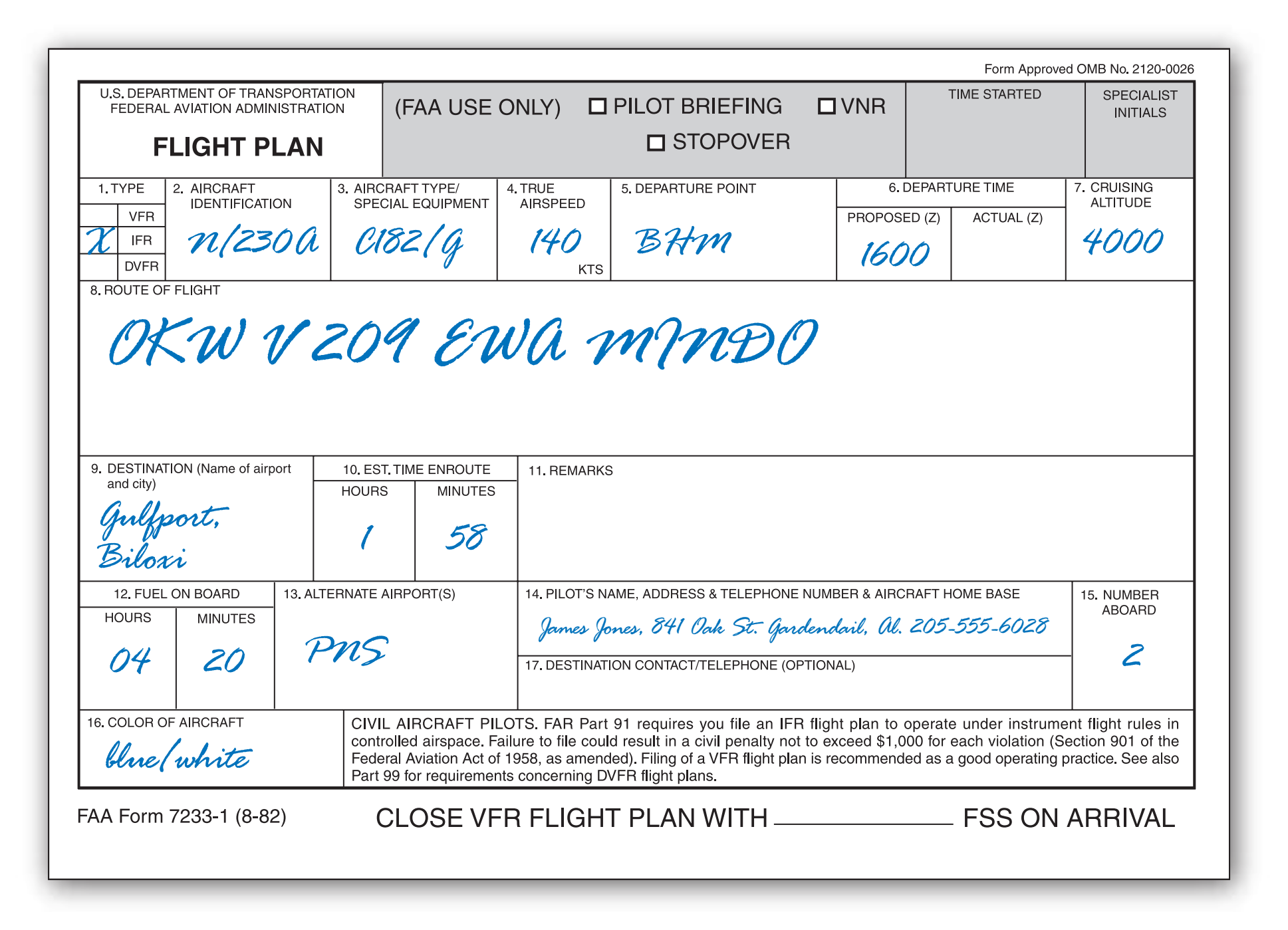
When the navigation log is finished, complete the flight plan in preparation for filing with flight service. [Figure 10-20]
Call an FSS for an updated weather briefing. Birmingham INTL airport is now reporting 700 overcast with 3 miles visibility, and Gulfport-Biloxi is now 400 overcast with 2 miles visibility. The alternate, Pensacola Regional Airport, continues to report adequate weather conditions with 2,000 overcast and 3 miles visibility in light rain.
Several pilot reports have been submitted for light icing conditions; however, all the reports are north of the route of flight and correspond to the AIRMET that was issued earlier. No pilot reports have included cloud tops, but the area forecast predicted cloud tops to flight level 240. Since the weather conditions appear to be improving, a flight plan can be filed using the completed form.
Analyze the latest weather minimums to determine if they exceed personal minimums. With the absence of icing reported along the route and steadily rising temperatures, structural icing should not be a problem. Make a note to do an operational check of the pitot heat during preflight and to take evasive action immediately should even light icing conditions be encountered in flight. This may require returning to BHM or landing at an intermediate spot before reaching GPT. The go/no-go decision is constantly reevaluated during the flight.
Once at the airport, conduct a thorough preflight inspection. A quick check of the logbooks indicates all airworthiness requirements have been met to conduct this IFR flight including an altimeter, static, and transponder test within the preceding 24 calendar months. In addition, a log on the clipboard indicates the VOR system has been checked within the preceding 30 days. Turn on the master switch and pitot heat, and quickly check the heating element before it becomes too hot. Then, complete the rest of the walk-around procedure. Since this is a flight in actual IFR conditions, place special emphasis on IFR equipment during the walk-around, including the alternator belt and antennas. After completing the preflight, organize charts, pencils, paper, and navigation log in the flight deck for quick, easy access. This is also the time to enter the planned flight into the GPS.