Chapter 2
En Route Operations
ATC controllers have an important role in helping pilots remain clear of obstructions. Controllers are instructed to issue a safety alert if the aircraft is in a position that, in their judgment, places the pilot in unsafe proximity to terrain, obstructions, or other aircraft. Once pilots inform ATC of action being taken to resolve the situation, the controller may discontinue the issuance of further alerts. A typical terrain/obstruction alert may sound like this: “(Aircraft call sign ), Low altitude alert. Check your altitude immediately. The MOCA in your area is 12,000.”
Minimum Turning Altitude (MTA)
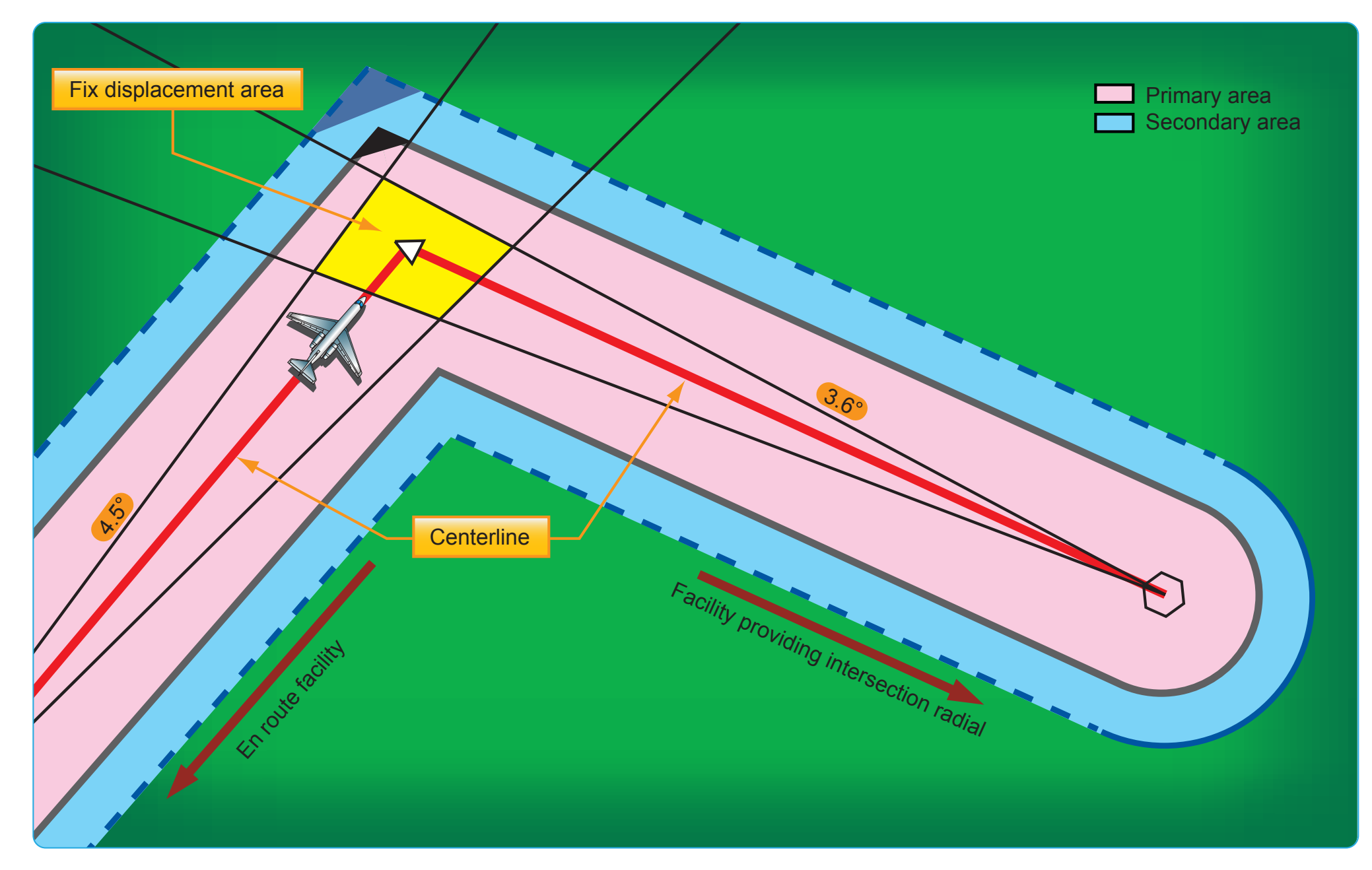
Minimum turning altitude (MTA) is a charted altitude providing vertical and lateral obstruction clearance based on turn criteria over certain fixes, NAVAIDs, waypoints, and on charted route segments. [Figure 2-59] When a VHF airway or route terminates at a NAVAID or fix, the primary area extends beyond that termination point. When a change of course on VHF airways and routes is necessary, the en route obstacle clearance turning area extends the primary and secondary obstacle clearance areas to accommodate the turn radius of the aircraft. Since turns at or after fix passage may exceed airway and route boundaries, pilots are expected to adhere to airway and route protected airspace by leading turns early before a fix. The turn area provides obstacle clearance for both turn anticipation (turning prior to the fix) and flyover protection (turning after crossing the fix). This does not violate the requirement to fly the centerline of the airway. Many factors enter into the construction and application of the turning area to provide pilots with adequate obstacle clearance protection. These may include aircraft speed, the amount of turn versus NAVAID distance, flight track, curve radii, MEAs, and MTA. [Figure 2-60]
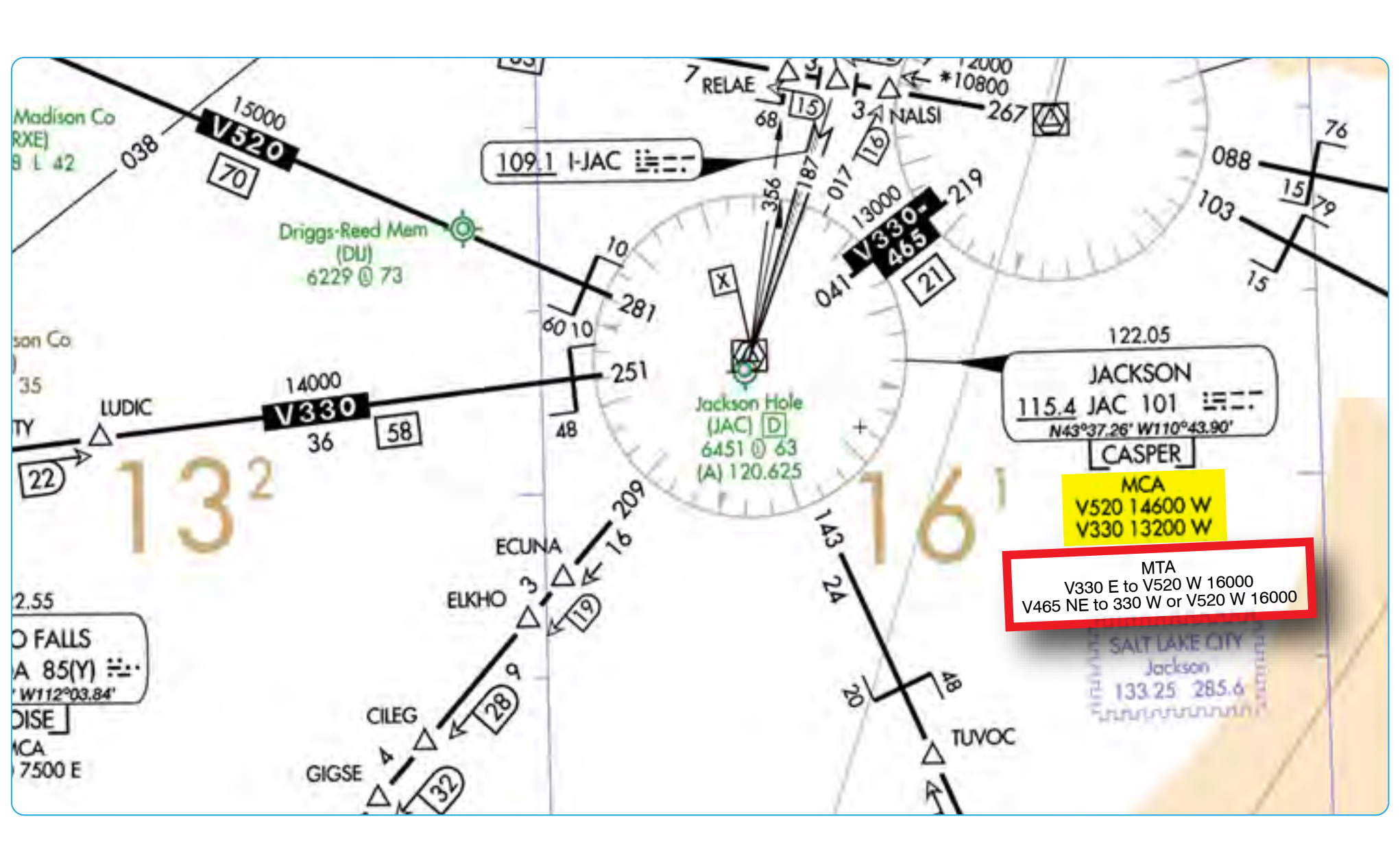
Due to increased airspeeds at 10,000 feet MSL or above, an expanded area in the vicinity of the turning fix is examined to ensure the published MEA is sufficient for obstacle clearance. In some locations (normally mountainous), terrain/obstacles in the expanded search area may obviate the published MEA and necessitate a higher minimum altitude while conducting the turning maneuver. Turning fixes requiring a higher MTA are charted with a flag along with accompanying text describing the MTA restriction. [Figure 2-59]
An MTA restriction normally consists of the ATS route leading to the turning fix, the ATS route leading from the turning fix, and an altitude (e.g., MTA V330 E TO V520 W 16000). When an MTA is applicable for the intended route of flight, pilots must ensure they are at or above the charted MTA prior to beginning the turn and maintain at or above the MTA until joining the centerline of the ATS route following the turn. Once established on the centerline following the turning fix, the MEA/MOCA determines the minimum altitude available for assignment.
An MTA may also preclude the use of a specific altitude or a range of altitudes during a turn. For example, the MTA may restrict the use of 10,000 through 11,000 feet MSL. In this case, any altitude greater than 11,000 feet MSL is unrestricted, as are altitudes less than 10,000 feet MSL provided MEA/MOCA requirements are satisfied.
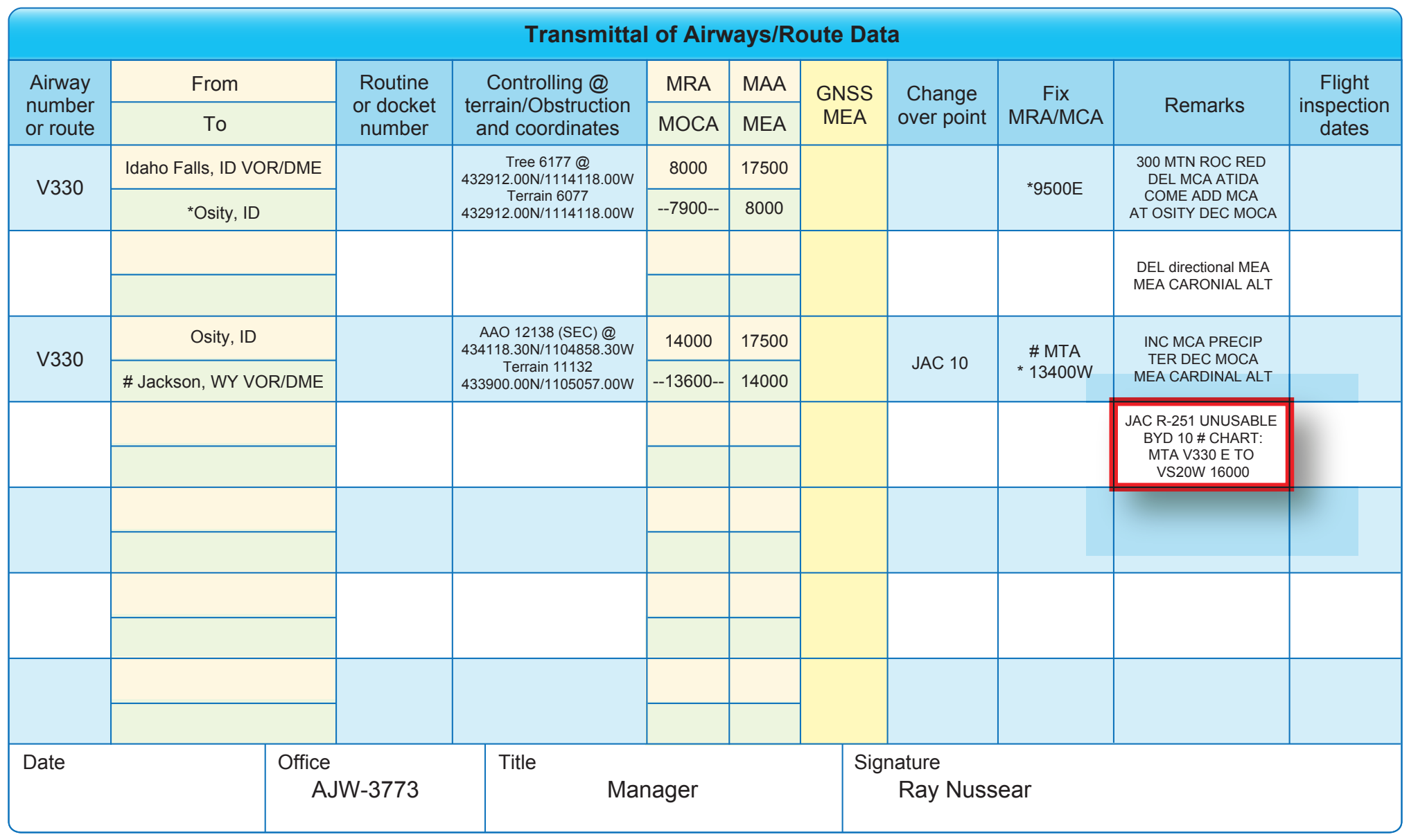
All MTA information associated with the airway/route inbound to the turn fix/facility is put in the remarks section of FAA Form 8260-16, Transmittal of Airways/Route Data, using the following format [Figure 2-61]: #CHART: MTA V330 E TO V520 W 16000 (Document on V330 FAA Form 8260-16) #CHART: MTA V465 NE TO V330 W OR V520 W 16000 (Document on V465 FAA Form 8260-16)
When an MTA is required by FAA Order 8260.3, paragraph 15-1-5c, enter the MTA information in the REMARKS section of FAA Form 8260-2, Radio Fix and Holding Data Record, as specified on the appropriate FAA Form 8260-16, Transmittal of Airways/Route Data, using the following format: MTA: V330 E TO V520 W 16000 MTA: V465 NE TO V330 W OR V520 W 16000
Minimum Crossing Altitude (MCA)
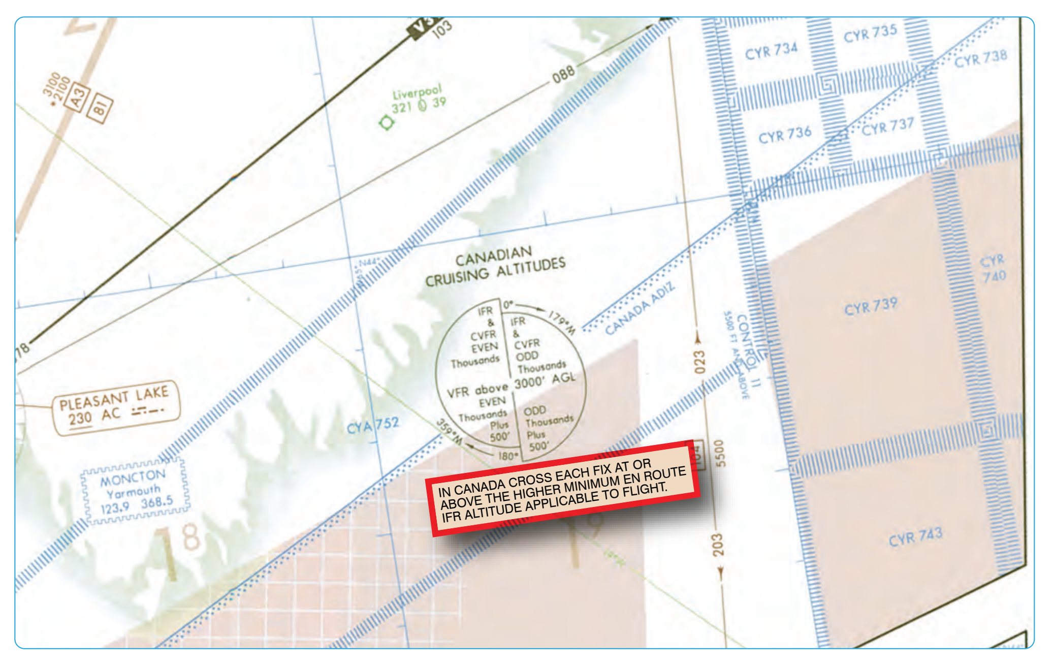
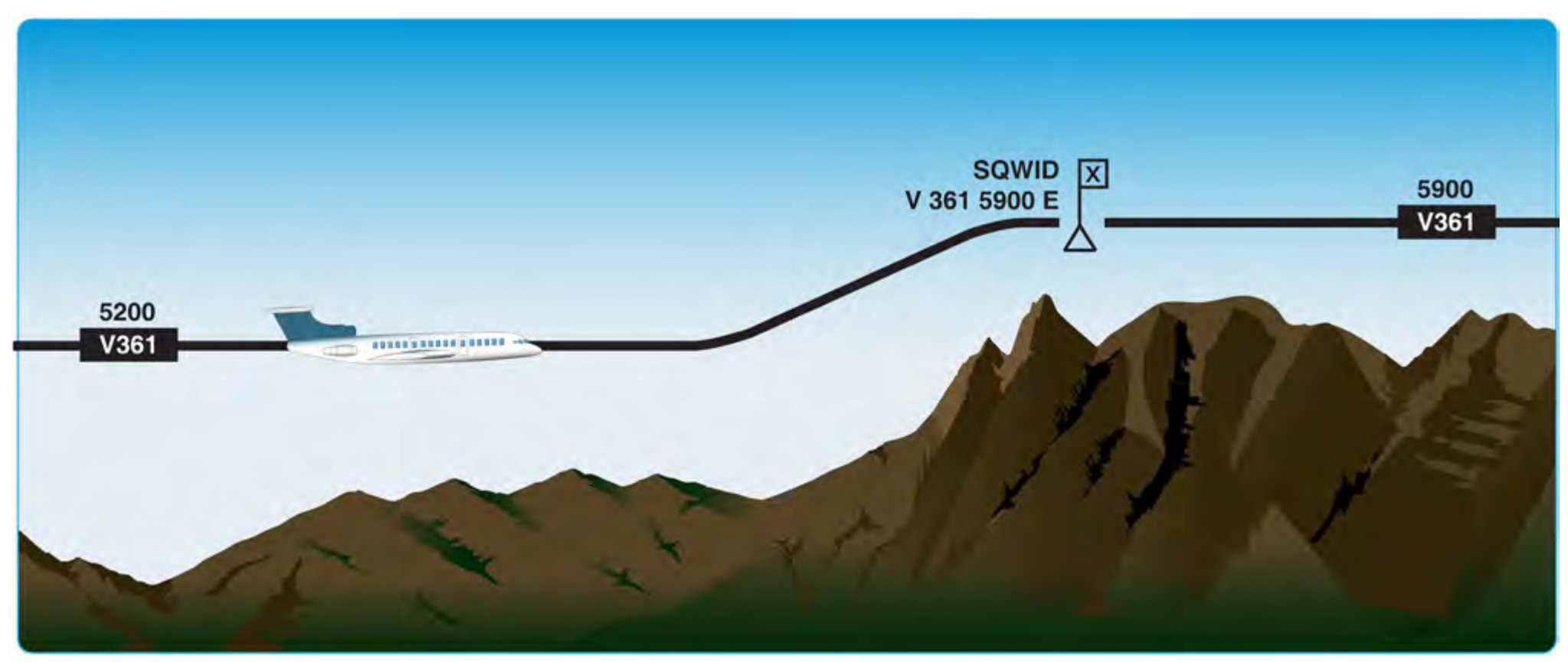
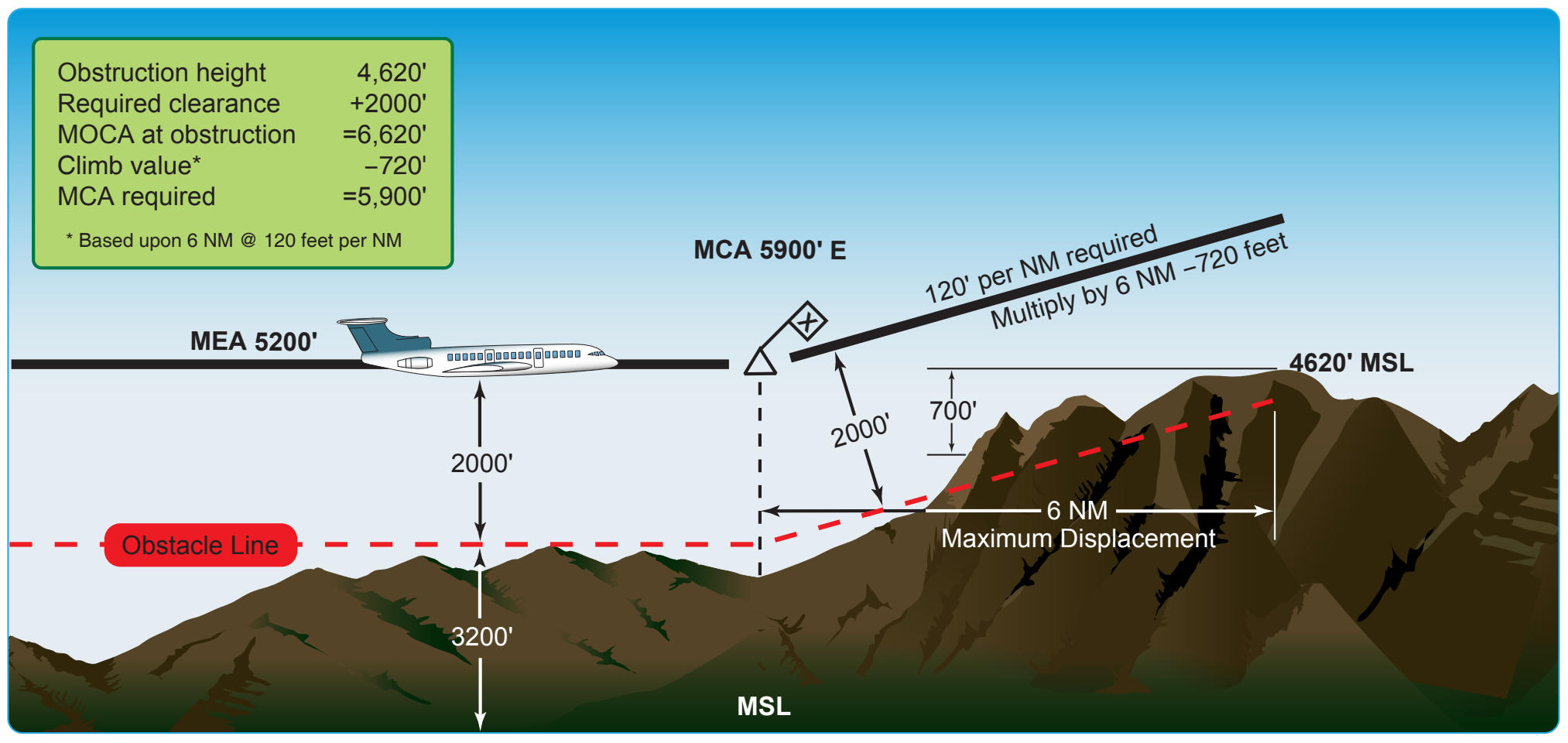
An MCA is the lowest altitude at certain fixes at which the aircraft must cross when proceeding in the direction of a higher minimum en route IFR altitude. [Figure 2-62] When applicable, MCAs are depicted on the en route chart. [Figure 2-59] MCAs are established in all cases where obstacles intervene to prevent pilots from maintaining obstacle clearance during a normal climb to a higher MEA after passing a point beyond which the higher MEA applies. The same protected en route area vertical obstacle clearance requirements for the primary and secondary areas are considered in the determination of the MCA. The standard for determining the MCA is based upon the following climb gradients and is computed from the flight altitude:
- Sea level through 5,000 feet MSL—150 feet per NM
- 5000 feet through 10,000 feet MSL—120 feet per NM
- 10,000 feet MSL and over—100 feet per NM
To determine the MCA seen on an en route chart, the distance from the obstacle to the fix is computed from the point where the centerline of the en route course in the direction of flight intersects the farthest displacement from the fix. [Figure 2-63] When a change of altitude is involved with a course change, course guidance must be provided if the change of altitude is more than 1,500 feet and/or if the course change is more than 45°, although there is an exception to this rule. In some cases, course changes of up to 90° may be approved without course guidance provided that no obstacles penetrate the established MEA requirement of the previous airway or route segment. Outside United States airspace, pilots may encounter different flight procedures regarding MCA and transitioning from one MEA to a higher MEA. In this case, pilots are expected to be at the higher MEA crossing the fix, similar to an MCA. Pilots must thoroughly review flight procedure differences when flying outside United States airspace. On IFR en route low altitude charts, routes and associated data outside the conterminous United States are shown for transitional purposes only and are not part of the high altitude jet route and RNAV route systems. [Figure 2-64]
Minimum IFR Altitude (MIA)
The MIA for operations is prescribed in 14 CFR Part 91. These MIAs are published on aeronautical charts and prescribed in 14 CFR Part 95 for airways and routes, and in 14 CFR Part 97 for standard instrument approach procedures. If no applicable minimum altitude is prescribed in 14 CFR Parts 95 or 97, the following MIA applies: In designated mountainous areas, 2,000 feet above the highest obstacle within a horizontal distance of 4 NM from the course to be flown; or other than mountainous areas, 1,000 feet above the highest obstacle within a horizontal distance of 4 NM from the course to be flown; or as otherwise authorized by the Administrator or assigned by ATC. MIAs are not flight checked for communication.