
Chapter 2
En Route Operations
United States standard values supporting typical RNP airspace are shown in Figure 2-56. Other RNP levels as identified by ICAO, other states, and the FAA may also be used.
Application of Standard RNP Levels
United States standard levels of RNP typically used for various routes and procedures supporting RNAV operations may be based on use of a specific navigational system or sensor, such as GPS, or on multi-sensor RNAV systems having suitable performance.
IFR En Route Altitudes
Minimum En Route Altitudes (MEAs), Minimum Reception Altitudes (MRAs), Maximum Authorized Altitudes (MAAs), Minimum Obstacle Clearance Altitudes (MOCAs), Minimum Turning Altitudes (MTAs) and Minimum Crossing Altitudes (MCAs) are established by the FAA for instrument flight along Federal airways, as well as some off-airway routes. The altitudes are established after it has been determined that the NAVAIDs to be used are adequate and so oriented on the airways or routes that signal coverage is acceptable, and that flight can be maintained within prescribed route widths.
For IFR operations, regulations require that pilots operate their aircraft at or above minimum altitudes. Except when necessary for takeoff or landing, pilots may not operate an aircraft under IFR below applicable minimum altitudes, or if no applicable minimum altitude is prescribed, in the case of operations over an area designated as mountainous, an altitude of 2,000 feet above the highest obstacle within a horizontal distance of 4 NM from the course to be flown. In any other case, an altitude of 1,000 feet above the highest obstacle within a horizontal distance of 4 NM from the course to be flown must be maintained as a minimum altitude. If both a MEA and a MOCA are prescribed for a particular route or route segment, pilots may operate an aircraft below the MEA down to, but not below, the MOCA, only when within 22 NM of the VOR. When climbing to a higher minimum IFR altitude (MIA), pilots must begin climbing immediately after passing the point beyond which that minimum altitude applies, except when ground obstructions intervene, the point beyond which that higher minimum altitude applies must be crossed at or above the applicable MCA for the VOR.
If on an IFR flight plan, but cleared by ATC to maintain VFR conditions on top, pilots may not fly below minimum en route IFR altitudes. Minimum altitude rules are designed to ensure safe vertical separation between the aircraft and the terrain. These minimum altitude rules apply to all IFR flights, whether in IFR or VFR weather conditions, and whether assigned a specific altitude or VFR conditions on top.
Minimum En Route Altitude (MEA)
The MEA is the lowest published altitude between radio fixes that assures acceptable navigational signal coverage and meets obstacle clearance requirements between those fixes. The MEA prescribed for a Federal airway or segment, RNAV low or high route, or other direct route applies to the entire width of the airway, segment, or route between the radio fixes defining the airway, segment, or route. MEAs for routes wholly contained within controlled airspace normally provide a buffer above the floor of controlled airspace consisting of at least 300 feet within transition areas and 500 feet within control areas. MEAs are established based upon obstacle clearance over terrain and manmade objects, adequacy of navigation facility performance, and communications requirements.
RNAV Minimum En Route Altitude
RNAV MEAs are depicted on some IFR en route low altitude charts, allowing both RNAV and non-RNAV pilots to use the same chart for instrument navigation.
Minimum Reception Altitude (MRA)
MRAs are determined by FAA flight inspection traversing an entire route of flight to establish the minimum altitude the navigation signal can be received for the route and for off-course NAVAID facilities that determine a fix. When the MRA at the fix is higher than the MEA, an MRA is established for the fix and is the lowest altitude at which an intersection can be determined.
Maximum Authorized Altitude (MAA)
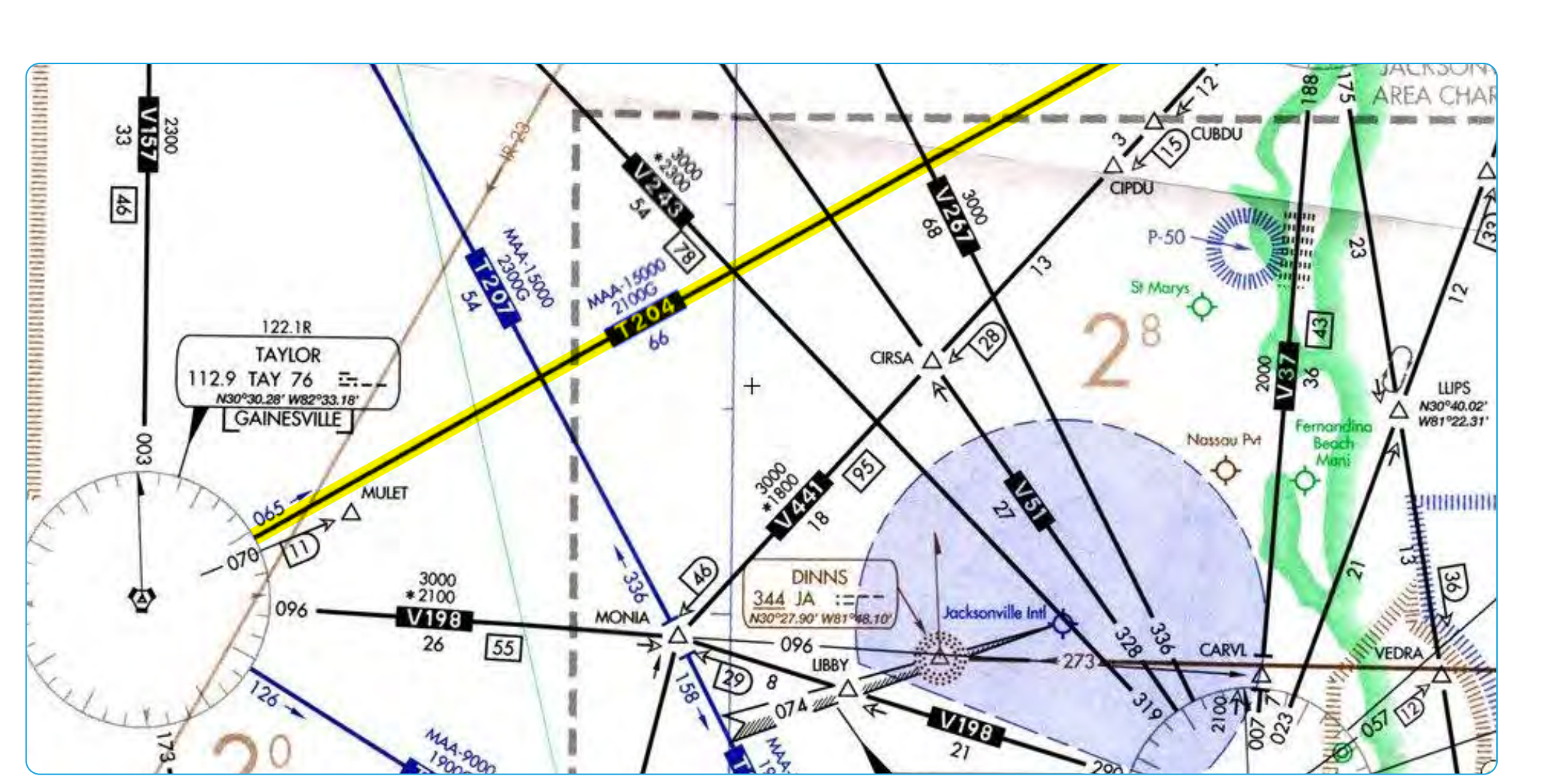
An MAA is a published altitude representing the maximum usable altitude or flight level for an airspace structure or route segment. [Figure 2-57] It is the highest altitude on a Federal airway, jet route, RNAV low or high route, or other direct route for which an MEA is designated at which adequate reception of navigation signals is assured. MAAs represent procedural limits determined by technical limitations or other factors, such as limited airspace or frequency interference of ground-based facilities.
Minimum Obstruction Clearance Altitude (MOCA)
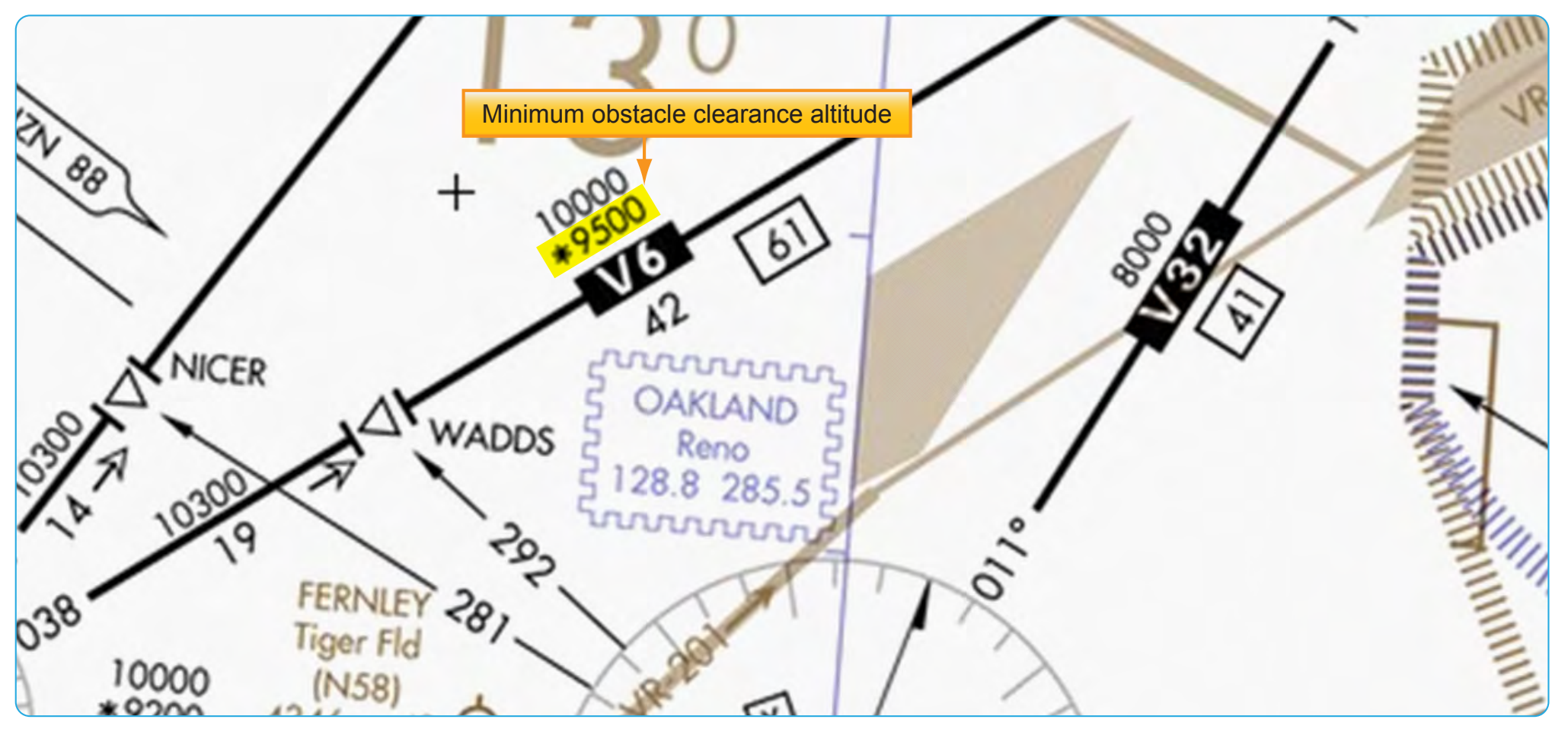
The MOCA is the lowest published altitude in effect between fixes on VOR airways, off-airway routes, or route segments that meets obstacle clearance requirements for the entire route segment. [Figure 2-58] This altitude also assures acceptable navigational signal coverage only within 22 NM of a VOR. The MOCA seen on the en route chart may have been computed by adding the required obstacle clearance (ROC) to the controlling obstacle in the primary area or computed by using a TERPS chart if the controlling obstacle is located in the secondary area. This figure is then rounded to the nearest 100 foot increment (i.e., 2,049 feet becomes 2,000, and 2,050 feet becomes 2,100 feet). An extra 1,000 feet is added in mountainous areas, in most cases.