IFR low- and high-altitude enroute chart legends, symbols, examples, and procedures.
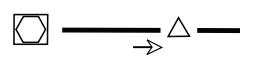
or both sides of centerline
Arrow indicates direction of route
See MTR tabulation for altitude range information
All IR and VR MTRs are shown except those VRs at or bleow 1500’ AGL
CAUTION: Inset charts do not depict MTRs
Alaska Capstone Routes (R Routes)
”R” Routes (R2010, R2015, R2020, R2025) are RNP 1 Navigation Specification. Users must have specific FAA authorization, through Operations Specification or Letter of Authorization, obtained from Flight Standards to use these routes. The aircraft’s lateral deviation display scaling must support the RNP 1 Enroute operation.
Alaska Capstone R Route (RNP route) — source page 81.
AIRSPACE INFORMATION Airway/Route Types Low and High Enroute Airway Data: Low Enroute Charts Victor Airways LF/MF Airway RNAV T Route GNSS Required RNAV TK Helicopter Route GNSS Required Preferred Direction Victor Route $V0 Unusable Route Segment Military Training Routes (MTR) MTRs 5NM or less both sides of centerline MTRs greater than 5NM either or both sides of centerline Arrow indicates direction of route See MTR tabulation for altitude range information All IR and VR MTRs are shown except those VRs at or bleow 1500’ AGL CAUTION: Inset charts do not depict MTRs Alaska Capstone Routes (R Routes) ”R” Routes (R2010, R2015, R2020, R2025) are RNP 1 Navigation Specification. Users must have specific FAA authorization, through Operations Specification or Letter of Authorization, obtained from Flight Standards to use these routes. The aircraft’s lateral deviation display scaling must support the RNP 1 Enroute operation. Low and High Enroute Charts ATS Route Oceanic Route VHF/UHF Data is depicted in Black. LF/MF Data is depicted in Brown. RNAV Route data is depicted in Blue High Enroute Charts Jet Routes Atlantic Routes Bahama Routes RNAV Q Routes Alaska Q Routes require GNSS and radar surveillance. Within the CONUS, GNSS or DME/DME/IRU RNAV required, unless otherwise indicated. DME/DME/IRU aircraft require radar surveillance. Preferred Direction Jet Routes Preferred Direction RNAV Q Routes Preferred Direction ATS Route Unusable Route Segment Substitute Route All relative and supporting data See NOTAMs or appropriate shown in brown. publication for specific information.
Source page 82
We use cookies to operate this website, improve performance, understand site traffic, and personalize your experience. Essential cookies are always active because they are required for the website to function.
Required for basic site functionality and security.
Help us understand how visitors use the website so we can improve it.
May be used for advertising, remarketing, or social media features.
You can update your choices anytime using Cookie Settings. View Privacy Policy