Aviation Training Experts™

other

Aeronautical Chart Users’ Guide

FAA Chart Users’ Guide Version 9 July 2026

IFR Enroute Low/High Altitude Symbols

IFR low- and high-altitude enroute chart legends, symbols, examples, and procedures.

Airspace Information (Continued) FIXES VHF/UHF LF/MF VHF/UHF VHF/UHF LF/MF N/A N/A N/A N/A REPORTING FUNCTION Compulsory Position Reporting Non-Compulsory Position Reporting Fix or Waypoint Coordinates Fix Coordinates are shown for compulsory, offshore and holding fixes. Waypoints Coordinates are shown when waypoint is not part of a RNAV route and when located on or beyond the boundary of the U.S. Continental Control (12 mile limit). Off-set arrows indicate facility forming a fix - Arrow points away from the VHF/UHF NAVAID - Arrow points towards the LF/MF NAVAID Distance Measuring Equipment (DME) Fix Denotes DME fix (distance same as airway / route mileage) Distance Measuring Equipment (DME) Fix Denotes DME fix (encircled mileage shown when not otherwise obvious) Example: First segment, 5NM; second segment 10NM; total milage provided in encircled DME arrow. Total Mileages between Compulsory Reporting Points or NAVAIDs Note: All mileages are in Nautical Miles MILEAGE BETWEEN OTHER FIXES, NAVAIDs AND/OR MILEAGE BREAKDOWN Mileage Breakdown or Computer Navigation Fix (CNF) Five letter identifier in parentheses indicates CNF with no ATC function FACILITY LOCATOR BOATS Crosshatch indicates Shutdown status of NAVAID RADIAL OUTBOUND FROM A VHF/UHF NAVAID All Radials are magnetic. BEARING INBOUND TO AN LF/MF NAVAID All Bearings are magnetic. MAGNETIC REFERENCE BEARING, outbound from a NAVAID or Fix Note: Not shown on joint Victor/RNAV or Jet/RNAV Routes. WAYPOINTS RNAV N/A N/A RNAV N/A N/A RNAV N/A N/A N/A N/A N/A
Source page 83

Airspace Information (Continued)
FAA aeronautical chart visual associated with “Minimum Enroute Altitude (MEA) — VHF/UHF Low Charts” (source page 83).
Minimum Enroute Altitude (MEA) — VHF/UHF Low Charts — source page 83.
FAA aeronautical chart visual associated with “Minimum Enroute Altitude (MEA) — LF/MF Low Charts” (source page 83).
Minimum Enroute Altitude (MEA) — LF/MF Low Charts — source page 83.
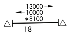
FAA aeronautical chart visual associated with “Directional MEAs — Low Charts” (source page 83).
Directional MEAs — Low Charts — source page 83.
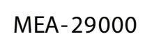
FAA aeronautical chart visual associated with “Minimum Enroute Altitude (MEA) — VHF/UHF High Charts” (source page 83).
Minimum Enroute Altitude (MEA) — VHF/UHF High Charts — source page 83.
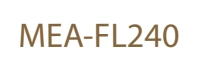
FAA aeronautical chart visual associated with “Minimum Enroute Altitude (MEA) — LF/MF High Charts” (source page 83).
Minimum Enroute Altitude (MEA) — LF/MF High Charts — source page 83.
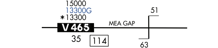
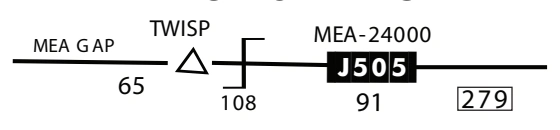
FAA aeronautical chart visual associated with “Minimum Enroute Altitude (MEA) gap — low-chart example” (source page 83).
Minimum Enroute Altitude (MEA) gap — low-chart example — source page 83.
FAA aeronautical chart visual associated with “MEA gap — High Charts” (source page 83).
MEA gap — High Charts — source page 83.
FAA aeronautical chart visual associated with “Maximum Authorized Altitude (MAA) — VHF/UHF” (source page 83).
Maximum Authorized Altitude (MAA) — VHF/UHF — source page 83.
FAA aeronautical chart visual associated with “Maximum Authorized Altitude (MAA) — LF/MF” (source page 83).
Maximum Authorized Altitude (MAA) — LF/MF — source page 83.
FAA aeronautical chart visual associated with “Minimum Obstruction Clearance Altitude (MOCA) — VHF/UHF” (source page 83).
Minimum Obstruction Clearance Altitude (MOCA) — VHF/UHF — source page 83.
FAA aeronautical chart visual associated with “Minimum Obstruction Clearance Altitude (MOCA) — LF/MF” (source page 83).
Minimum Obstruction Clearance Altitude (MOCA) — LF/MF — source page 83.
FAA aeronautical chart visual associated with “Minimum Turning Altitude (MTA) or Minimum Crossing Altitude (MCA) — VHF/UHF” (source page 83).
Minimum Turning Altitude (MTA) or Minimum Crossing Altitude (MCA) — VHF/UHF — source page 83.
FAA aeronautical chart visual associated with “Minimum Turning Altitude (MTA) or Minimum Crossing Altitude (MCA) — LF/MF” (source page 83).
Minimum Turning Altitude (MTA) or Minimum Crossing Altitude (MCA) — LF/MF — source page 83.
FAA aeronautical chart visual associated with “Minimum Reception Altitude (MRA) — VHF/UHF” (source page 83).
Minimum Reception Altitude (MRA) — VHF/UHF — source page 83.
FAA aeronautical chart visual associated with “Minimum Reception Altitude (MRA) — LF/MF” (source page 83).
Minimum Reception Altitude (MRA) — LF/MF — source page 83.
FAA aeronautical chart visual associated with “Altitude change symbol — VHF/UHF” (source page 83).
Altitude change symbol — VHF/UHF — source page 83.
FAA aeronautical chart visual associated with “Altitude change symbol — LF/MF” (source page 83).
Altitude change symbol — LF/MF — source page 83.