IFR low- and high-altitude enroute chart legends, symbols, examples, and procedures.
Changeover point — VHF/UHF low/high charts — source page 83.
Changeover point — LF/MF low/high charts — source page 83.
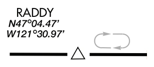
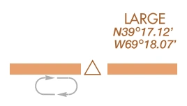
Holding pattern — VHF/UHF — source page 83.
Holding pattern — LF/MF — source page 83.
Holding pattern maximum restriction — 210 knots — source page 83.
All Altitudes Are MSL Unless Otherwise Noted.
Directional MEAs
MEAs are shown on IFR High Altitude Charts when MEA is other than 18,000’.
MINIMUM ENROUTE ALTITUDE (MEA) GAP
MEA is established when there is a gap in navigation signal coverage.
Maximum Authorized Altitude (MAA)
All Altitudes Are MSL Unless Otherwise Noted.
MAAs are shown on IFR High Altitude Charts when MAA is other than 45,000’.
Minimum Obstruction Clearance Altitude (MOCA)
All Altitudes Are MSL Unless Otherwise Noted.
See Low Enroute Chart Example below for examples of both MTAs and MCAs.
MEA, MOCA and/or MAA change at other than NAVAIDs
Changeover Point giving mileage to NAVAIDs (Not shown at midpoint locations.)
RNAV Holding Pattern Magnetic Reference Bearing is determined by the isogonic value at the waypoint or fix.
Holding Pattern with maximum restriction airspeed 210K applies to altitudes 6000’ to and including 14000’. 175K applied to all altitudes. Airspeed depicted is Indicated Airspeed (IAS)
Cookie Preferences
We use cookies to operate this website, improve performance, understand site traffic, and personalize your experience. Essential cookies are always active because they are required for the website to function.
Required for basic site functionality and security.
Help us understand how visitors use the website so we can improve it.
May be used for advertising, remarketing, or social media features.
You can update your choices anytime using Cookie Settings. View Privacy Policy