Aviation Training Experts™

other

Aeronautical Chart Users’ Guide

FAA Chart Users’ Guide Version 9 July 2026

VFR Flyway Planning Charts

Searchable VFR Flyway Planning Chart symbols and explanations for pilots.

Source page 43

VFR Flyway Planning Charts

GENERAL INFORMATION

AIRPORTS

Landplane

No distinction is made between airports with fuel and those without fuel. Runways may be exaggerated to clearly
FAA aeronautical chart visual associated with “Landplane airport with unpaved runways — Agua Dulce (L70)” (source page 43).
Landplane airport with unpaved runways — Agua Dulce (L70) — source page 43.
portray the pattern. Hard-
surfaced runways that are
closed but still exist are
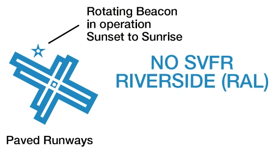
FAA aeronautical chart visual associated with “Landplane airport with paved runways, rotating beacon, and NO SVFR — Riverside (RAL)” (source page 43).
Landplane airport with paved runways, rotating beacon, and NO SVFR — Riverside (RAL) — source page 43.
included in the charted pattern.
FAR 91 - Fixed wing special
VFR operations prohibited.
(Pvt): Non-public use having
FAA aeronautical chart visual associated with “(Pvt) non-public-use landplane airport — Compton” (source page 43).
(Pvt) non-public-use landplane airport — Compton — source page 43.
landmark value.
“OBJECTIONABLE”: This
FAA aeronautical chart visual associated with “Objectionable landplane airport — may adversely affect airspace use” (source page 43).
Objectionable landplane airport — may adversely affect airspace use — source page 43.
airport may adversely affect