Searchable explanations of VFR chart terrain, water, obstructions, radio aids, airports, airspace, foreign areas, and chart coverage.
The Flight Edit crew visually verifies the cultural, topographic, and obstacle data. Charts are generally flight-checked every four years. This review includes checking for any obstruction that has been recently built, altered, or dismantled without proper notification. — source page 11.
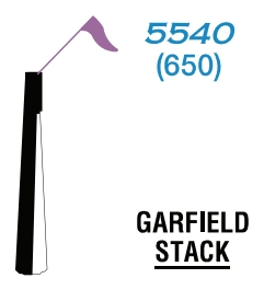
Whenever possible, the FAA depicts specific obstacles on charts. However, in high-density areas like city complexes, only the highest obstacle is represented on the chart using the group obstacle symbol to maximize legibility. — source page 11.
Whenever possible, the FAA depicts specific obstacles on charts. However, in high-density areas like city complexes, only the highest obstacle is represented on the chart using the group obstacle symbol to maximize legibility.
Group-obstacle symbol — 4,977 ft MSL / 1,432 ft AGL example — source page 11.
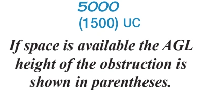
Obstacles under construction are indicated by placing the letters UC adjacent to the obstacle type.
Obstacles under construction are indicated by placing the letters UC adjacent to the obstacle type. — source page 11.
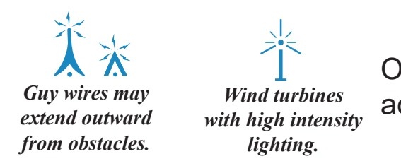
Obstacles with high-intensity strobe lighting systems may operate part-time or by proximity activation and are shown as follows: — source page 11.
Obstacles with high-intensity strobe lighting systems may operate part-time or by proximity activation and are shown as follows:
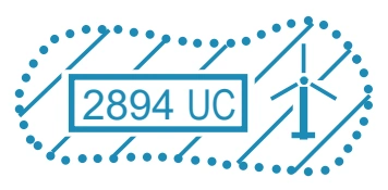
Concentrated obstructions of wind turbine farms shall be portrayed by an overlying hatched area and dotted outline to represent the approximate parameters of the farm. One or more single turbine symbols will populate the farm. A boxed elevation figure representing the MSL elevation of the highest wind turbine within the area shall be placed inside the farm or, if space is limited, just outside. Pilots are reminded that wind turbine blades and/or blade tips are not lighted. Wind turbine obstruction lights are located on top of the nacelle (generator) at the hub of wind turbines, which in some cases can be 200-300’ below the rotating blade tips.
Concentrated obstructions of wind turbine farms shall be portrayed by an overlying hatched area and dotted outline to represent the approximate parameters of the farm. One or more single turbine symbols will populate the farm. A boxed elevation figure representing the MSL elevation of the highest wind turbine within the area shall be placed inside the farm… — source page 11.
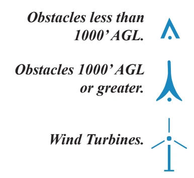
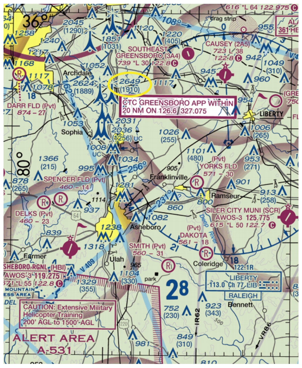
3. Different color tints show bands of elevation relative to sea level. These colors range from light green for the lower elevations, to dark brown for the higher elevations. 4. Obstruction symbols show man made vertical features that could affect safe navigation. The FAA maintains a database of obstacles. Aeronautical Specialists evaluate each obstacle based on charting specifications before adding it to a a visual chart. When a Specialist is not able to verify the position or elevation of an obstacle, it is marked UC, meaning it is "under construction" or being reported, but has not been verified. The FAA uses a Digital Obstacle File (DOF) to collect and disseminate data. Because land and obstructions frequently change, the source data on obstructions and terrain is occasionally incomplete or not accurate enough for use in aeronautical publications. For example, when the FAA receives notification about an obstruction, and there is insufficient detail to determine its position and elevation, the FAA Flight Edit Program conducts an investigation. The Flight Edit crew visually verifies the cultural, topographic, and obstacle data. Charts are generally flightchecked every four years. This review includes checking for any obstruction that has been recently built, altered, or dismantled without proper notification. Wind Turbines. Obstacles 1000’ AGL or greater. Obstacles less than 1000’ AGL. Sectional Charts and Terminal Area (TACs) typically show man-made obstacles extending more than 200' Above Ground Level (AGL), or more than 299' AGL in yellow city tint. Obstacles may be lit or unlit. Features considered to be hazardous obstacles to low-level flight are; smokestacks, tanks, factories, lookout towers, antennas, and wind turbines, etc. Man-made features used by FAA Air Traffic Control as checkpoints use a graphic symbol shown in black with the required elevation data in blue. The elevation of the top of the obstacle above Mean Sea Level (MSL) and the height of the structure (AGL) is also indicated (when known or can be reliably determined by a Specialist). The AGL height is in parentheses below the MSL elevation. In extremely congested areas, the FAA typically omits the AGL values to avoid confusion. Group Obstacle Symbol Whenever possible, the FAA depicts specific obstacles on charts. However, in high-density areas like city complexes, only the highest obstacle is represented on the chart using the group obstacle symbol to maximize legibility. If space is available the AGL height of the obstruction is shown in parentheses. Obstacles under construction are indicated by placing the letters UC adjacent to the obstacle type. Guy wires may extend outward from obstacles. Wind turbines with high intensity lighting. Obstacles with high-intensity strobe lighting systems may operate part-time or by proximity activation and are shown as follows: 2894 UC Concentrated obstructions of wind turbine farms shall be portrayed by an overlying hatched area and dotted outline to represent the approximate parameters of the farm. One or more single turbine symbols will populate the farm. A boxed elevation figure representing the MSL elevation of the highest wind turbine within the area shall be placed inside the farm or, if space is limited, just outside. Pilots are reminded that wind turbine blades and/or blade tips are not lighted. Wind turbine obstruction lights are located on top of the nacelle (generator) at the hub of wind turbines, which in some cases can be 200-300’ below the rotating blade tips.
Source page 12
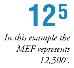
The Maximum Elevation Figure (MEF) represents the highest elevation within a quadrant, including terrain and other vertical obstacles (towers, trees, etc.). A quadrant on Sectionals is the area bounded by ticked lines dividing each 30 minutes of latitude and each 30 minutes of longitude. MEF figures are rounded up to the nearest 100' value and the last two digits of the number are not shown.
MEFs over land and open water areas are used in areas containing man-made obstacles such as oil rigs. — source page 12.
MEFs over land and open water areas are used in areas containing man-made obstacles such as oil rigs.
In the determination of MEFs, the FAA uses extreme care to calculate the values based on the existing elevation data shown on source material. Aeronautical Information Specialists use the following procedure to calculate MEFs:
MEF - Man-made Obstacle
When a man-made obstacle is more than 200' above the highest terrain within the quadrant:
Determine the elevation of the top of the obstacle above MSL.
Add the possible vertical error of the source material to the above figure (100’ or 1/2 contour interval when interval on source exceeds 200’. U.S. Geological Survey Quadrangle Maps with contour intervals as small as 10’ are normally used).
Round the resultant figure up to the next higher hundred-foot level.
1. Determine the elevation of the top of the obstacle above MSL.
2. Add the possible vertical error of the source material to the above figure (100’ or 1/2 contour interval when interval on source exceeds 200’. U.S. Geological Survey Quadrangle Maps with contour intervals as small as 10’ are normally used).
3. Round the resultant figure up to the next… — source page 12.
Cookie Preferences
We use cookies to operate this website, improve performance, understand site traffic, and personalize your experience. Essential cookies are always active because they are required for the website to function.
Required for basic site functionality and security.
Help us understand how visitors use the website so we can improve it.
May be used for advertising, remarketing, or social media features.
You can update your choices anytime using Cookie Settings. View Privacy Policy