Searchable explanations of VFR chart terrain, water, obstructions, radio aids, airports, airspace, foreign areas, and chart coverage.
Public-use airport with hard-surfaced runway(s) greater than 8,069 feet or multiple shorter runways — source page 14.
Public-use airport with hard-surfaced runway 1,500–8,069 ft — source page 14.
Public-use airport with other-than-hard-surfaced runway — source page 14.
Seaplane-base symbol — source page 14.
Military-airport symbol — other-than-hard-surfaced runway — source page 14.
Foreign airport symbol — source page 14.
Airport fuel-availability tick marks — source page 14.
Other-airport status symbols — heliport, flight park, unverified, restricted/private, abandoned — source page 14.
RADIO AIDS TO NAVIGATION On VFR Charts, information about radio aids to navigation (NAVAID) are boxed, as illustrated. Duplication of data is avoided. When two or more radio aids in a general area have the Weather Camera same name with different frequencies, Tactical Air Navigation (TACAN) channel numbers, or identification letters, and no misinterpretation can result, the name of the radio aid may be indicated only once within the identification box. Very High Frequency/Ultra High Frequency (VHF/UHF) NAVAID names and identification boxes (shown in blue) take precedence. Only those items that differ (e.g., frequency, Morse Code) are repeated in the box in the appropriate color. The choice of separate or combined boxes is made in each case on the basis of economy of space and clear identification of the radio aids. A NAVAID that is physically located on an airport may not always be represented as a typical NAVAID symbol. A small open circle indicates the NAVAID location when collocated with an airport icon. The type of NAVAID will be identified by: "VOR," (VHF Omni-Directional Range) "VORTAC" (VOR Tactical Aircraft Control), "VOR-DME," (VOR-Distance Measuring Equipment) or “DME” (Distance Measuring Equipment) positioned on and breaking the top line of the NAVAID box. DMEs are shown without the compass rose. AIRPORTS Airports in the following categories are charted as indicated (additional symbols are shown later in this Section). Public use airports: Hard-surfaced runways greater than 8069’ or some multiple runways less than 8069’ Hard-surfaced runways 1500’ to 8069’ Other than hard-surfaced runways Seaplane bases Military airports: Other than hard-surfaced runways Foreign airports: Hard-surfaced runways are depicted the same as public-use airports. U.S. military airports are identified by abbreviations such as AAF (Army Air Field), AFB (Air Force Base), MCAS (Marine Corps Air Station), NAS (Naval Air Station), NAV (Naval Air Facility), and NAAS (Naval Auxiliary Air Station). Fuel Available: Fuel availability indicated by use of tick marks around the basic airport symbol. Consult Chart Supplement for details and availability. Other airports with or without fuel:
Source page 15
Airports are plotted in their true geographic position unless the symbol conflicts with a NAVAID at the same location. In such cases, the airport symbol will be displaced, but the relationship between the airport and the NAVAID will be retained. When a waypoint is collocated with a towered airport, the waypoint symbol will not be charted and the waypoint name followed by (WP) will be shown leadered to the waypoint true location. When depicting a seaplane base, the eye of the anchor symbol will be charted as close to the docking area as possible, with the remainder of the symbol in the water.
Airports are identified by their official FAA designated name.
The elevation of an airport is the highest point on the usable portion of the landing areas. Runway length is the length of the longest active runway, including displaced thresholds and excluding overruns. Runway length is shown to the nearest 100', using 70 as the rounding point; a runway 8070' in length is charted as 81, while a runway 8069' in length is… — source page 15.
The elevation of an airport is the highest point on the usable portion of the landing areas. Runway length is the length of the longest active runway, including displaced thresholds and excluding overruns. Runway length is shown to the nearest 100', using 70 as the rounding point; a runway 8070' in length is charted as 81, while a runway 8069' in length is charted as 80. If an airport has waterways, it will be indicated by a seaplane base symbol and additional elevation, lighting, and length information under primary airport information.
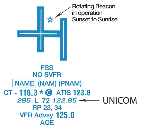
Flight Service Station on fieldElevation in feetAirports where fixed wing special VFR operations are prohibited (shown above airport name) FAR 91Lighting in operation Sunset to SunriseIndicates FAR 93 Special Air Traffic Rules and Airport Traffic PatternLighting limitations exist; refer to Chart SupplementLocation IdentifierLength of longest runway in hundreds of feet; usable length may be lessICAO Location IdentifierAeronautical advisory stationControl Tower (CT) - primary frequencyRunways with Right Traffic Patterns (public use)Star indicates operation part-time. See tower frequencies tabulation for hours of operationSee Chart SupplementFollows the Common Traffic Advisory Frequency (CTAF)VFR Advisory Service Shown when ATIS is not available and frequency is other than the primary CT frequencyAutomatic Terminal Information ServicesWeather CameraAutomatic Flight Information ServiceAirport of EntryAutomated Surface Weather Observing Systems; shown when full-time ATIS is not availableWhen information is lacking, the respective character is replaced by a dash. Lighting codes refer to runway edge lights and may not represent the longest runway or full length lighting.
Flight Service Station on field | | Elevation in feet |
Airports where fixed wing special VFR operations are prohibited (shown above airport name) FAR 91 | | Lighting in operation Sunset to Sunrise |
Indicates FAR 93 Special Air Traffic Rules and Airport Traffic Pattern | | Lighting limitations exist; refer to Chart Supplement |
Location Identifier | | Length of longest runway in hundreds of feet; usable length may be less |
ICAO Location Identifier | | Aeronautical advisory station |
Control Tower (CT) - primary frequency | | Runways with Right Traffic Patterns (public use) |
Star indicates operation part-time. See tower frequencies tabulation for hours of operation | | See Chart Supplement |
Follows the Common Traffic Advisory Frequency (CTAF) | | VFR Advisory Service Shown when ATIS is not available and frequency is other than the primary CT frequency |
Automatic Terminal Information Services | | Weather Camera |
Automatic Flight Information Service | | Airport of Entry |
Automated Surface Weather Observing Systems; shown when full-time ATIS is not available | | When information is lacking, the respective character is replaced by a dash. Lighting codes refer to runway edge lights and may not represent the longest runway or full length lighting. |
FSS — Flight Service Station on field — source page 15.
Elevation in feet — source page 15.
NO SVFR — fixed-wing special-VFR operations prohibited — source page 15.
Lighting in operation Sunset to Sunrise — source page 15.
Cookie Preferences
We use cookies to operate this website, improve performance, understand site traffic, and personalize your experience. Essential cookies are always active because they are required for the website to function.
Required for basic site functionality and security.
Help us understand how visitors use the website so we can improve it.
May be used for advertising, remarketing, or social media features.
You can update your choices anytime using Cookie Settings. View Privacy Policy