Searchable explanations of VFR chart terrain, water, obstructions, radio aids, airports, airspace, foreign areas, and chart coverage.
See NOTAMs or Chart Supplement for Class E surface-area effective hours — source page 17.
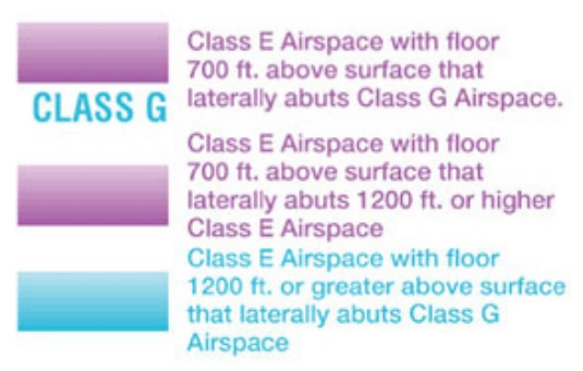
Class E airspace floor vignette legend — 700 feet, 1,200 feet or higher, and Class G — source page 17.
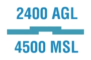
Class E floor annotation — 2,400 ft AGL / 4,500 ft MSL — source page 17.
UNCONTROLLED AIRSPACE
SPECIAL USE AIRSPACE
OTHER AIRSPACE AREAS
Mode C and ADS-B Out 30 NM airspace boundary — source page 17.
FAR 93 special-air-traffic-rules airport — Truckee-Tahoe — source page 17.
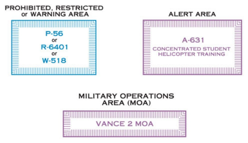
Special-use-airspace box legend — prohibited/restricted/warning, alert area, and MOA — source page 17.
Class E Surface (SFC) Airspace is symbolized with a magenta dashed line. Class E (SFC) operating less than continuous is indicated by the following note: Class E Airspace exists at 1200' AGL unless designated otherwise. The lateral and vertical limits of all Class E, (up to, but not including 18,000') are shown by narrow bands of vignette on Sectionals and TACs. Controlled airspace floors of 700' above the ground are defined by a magenta vignette; floors other than 700' that laterally abut uncontrolled airspace (Class G) are defined by a blue vignette; differing floors greater than 700' above the ground are annotated by a symbol and a number indicating the floor. If the ceiling is less than 18,000' MSL, the value (preceded by the word "ceiling") is shown along the limits of the controlled airspace. These limits are shown with the same symbol indicated above. UNCONTROLLED AIRSPACE Class G Airspace within the United States extends up to 14,500' Mean Sea Level. At and above this altitude is Class E, excluding the airspace less than 1500' above the terrain and certain special use airspace areas. SPECIAL USE AIRSPACE Special Use Airspace (SUA) confines certain flight activities and restricts entry, or cautions other aircraft operating within specific boundaries. Except for Controlled Firing Areas, SUA areas are depicted on VFR Charts. Controlled Firing Areas are not charted because their activities are suspended immediately when spotter aircraft, radar, or ground lookout positions indicate an aircraft might be approaching the area. Nonparticipating aircraft are not required to change their flight paths. SUA areas are shown in their entirety (within the limits of the chart), even when they overlap, adjoin, or when an area is designated within another area. The areas are identified by type and identifying name/ number, and are positioned either within or immediately adjacent to the area. * Alert Areas do not extend into Class A, B, C and D airspace, or Class E airport surface areas. OTHER AIRSPACE AREAS Mode C Required Airspace (from the surface to 10,000' MSL) within a 30 NM radius of the primary airport(s) for which a Class B is designated, is depicted by a solid magenta line. MODE C & ADS-B OUT 30 NM Mode C is required, but not depicted for operations within and above all Class C up to 10,000' MSL. Enroute Mode C requirements (at and above 10,000' MSL except in airspace at and below 2500' AGL) are not depicted. See FAR 91.215 and the AIM. FAR 93 Airports and heliports under Federal Aviation Regulation 93 (FAR 93), (Special Air Traffic Rules and Airport Traffic Patterns), are shown by "boxing" the airport name. FAR 91 Airports where fixed wing special visual flight rules operations are prohibited (FAR 91) are shown with the type "NO SVFR" above the airport name. Miscellaneous Activity Areas are indicated with the symbols illustrated on p. 31. The charting of a symbol in the area of an airport indicates both miscellaneous activity and regular air operations may be present at these locations. Due to the wide range of hazards associated with these areas, pilots are expected to check NOTAMs prior to flight for additional information regarding the airspace.
Source page 18
National Security Area boundary — broken magenta line — source page 18.
Special Flight Rules Area (SFRA) boundary symbol — source page 18.
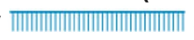
Washington, DC Flight Restricted Zone boundary — blue comb line — source page 18.
Temporary Flight Restriction related to national security — broken blue line — source page 18.
Air Defense Identification Zone boundary symbol — source page 18.
National Defense Airspace temporary-TFR cross-hatched boundary — source page 18.
Terminal Radar Service Area outer-boundary symbol — source page 18.
Palm Springs TRSA name — source page 18.
Military Training Route IR21 with direction arrow — source page 18.
Cookie Preferences
We use cookies to operate this website, improve performance, understand site traffic, and personalize your experience. Essential cookies are always active because they are required for the website to function.
Required for basic site functionality and security.
Help us understand how visitors use the website so we can improve it.
May be used for advertising, remarketing, or social media features.
You can update your choices anytime using Cookie Settings. View Privacy Policy