
Chapter 17
Tropical Weather
17.1 Introduction
Technically, the Tropics lie between latitudes 23½° N and 23½° S. However, weather typical of this region sometimes extends as much as 45° from the Equator. One may think of the Tropics as uniformly rainy, warm, and humid. The facts are, however, that the Tropics contain both the wettest and driest regions of the world.
This chapter describes the basic circulation over the Tropics, terrain influences that determine arid and wet regions, and transitory systems that invade or disturb the basic tropical circulation.
17.2 Circulation
Chapter 7, Earth-Atmosphere Heat Imbalances, stated that wind blowing out of the subtropical high-pressure belts toward the Equator form the northeast and southeast trade winds of the two hemispheres. These trade winds converge in the vicinity of the Equator where air rises. This convergence zone is referred to as the Intertropical Convergence Zone (ITCZ). In some areas of the world, seasonal temperature differences between land and water areas generate rather large circulation patterns that overpower the trade wind circulation; these areas are monsoon regions. Tropical weather discussed here includes the subtropical high-pressure belts, the trade wind belts, the ITCZ, and monsoon regions.
17.2.1 Subtropical High-Pressure Belts
If the surfaces under the subtropical high-pressure belts were all water of uniform temperature, the high-pressure belts would be continuous highs around the globe. The belts would be areas of descending or subsiding air and would be characterized by strong temperature inversions and very little precipitation. However, land surfaces at the latitudes of the high-pressure belts are generally warmer throughout the year than are water surfaces. Thus, the high-pressure belts are broken into semipermanent high-pressure areas over oceans with troughs or lows over continents, as shown in Figure 17-1 and Figure 17-2. The subtropical highs shift southward during the Northern Hemisphere winter and northward during summer. The seasonal shift, the height and strength of the inversion, and terrain features determine the weather in the subtropical high-pressure belts.
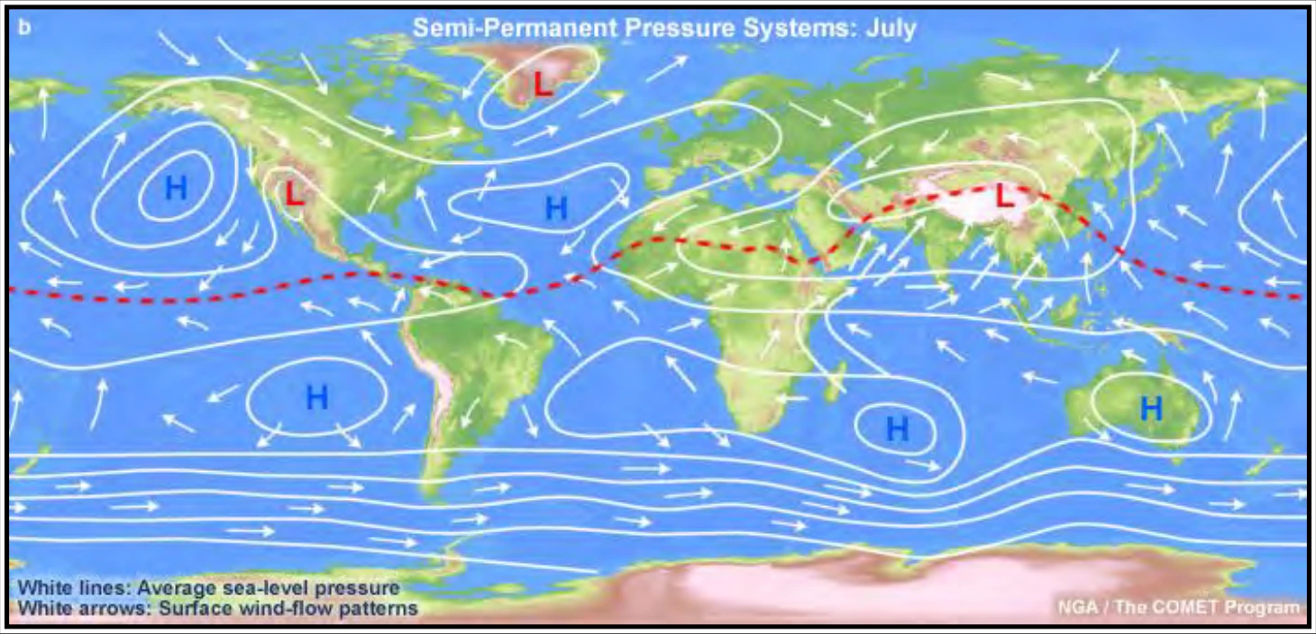
In the warm Northern Hemisphere, warm land areas tend to have low pressure and cool oceanic areas tend to have high pressure. In the cool Southern Hemisphere, the pattern is reversed: cool land areas tend to have high pressure and water surfaces have low pressure. However, the relationship is not so evident in the Southern Hemisphere because of relatively small amounts of land. The subtropical high-pressure belts are clearly evident at about 30° latitude in both hemispheres. The red dashed line shows the ITCZ.
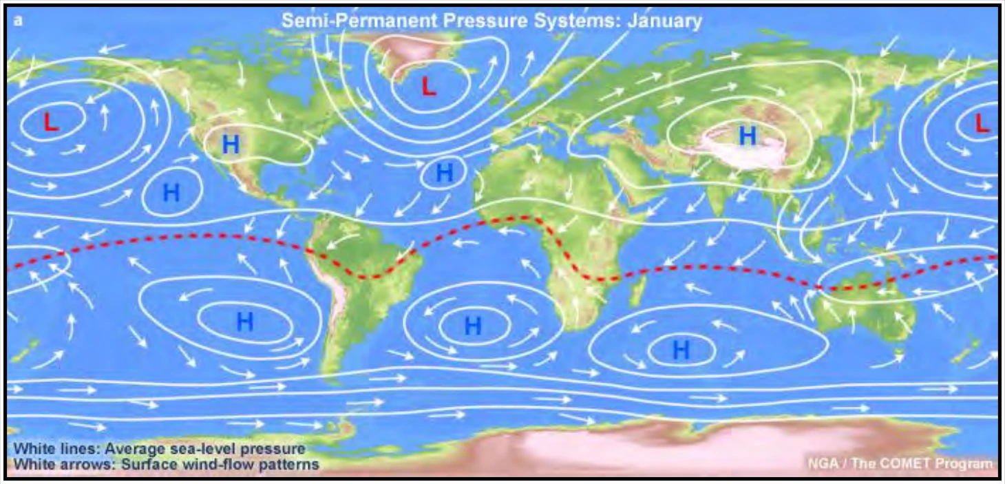
In this season, the pattern from Figure 17-1 is reversed. In the cool Northern Hemisphere, cold continental areas are predominantly areas of high pressure, while warm oceans tend to be low-pressure areas. In the warm Southern Hemisphere, land areas tend to have low pressure and oceans have high pressure. The subtropical high-pressure belts are evident in both hemispheres. Note that the pressure belts shift southward in January and northward in July, with the shift in the zone of maximum heating. The red dashed line shows the ITCZ.
17.2.1.1 Continental Weather
Along the west coasts of continents under a subtropical high, the air is stable. The inversion is strongest and lowest where the east side of the subtropical high-pressure area overlies the west side of a continent. Moisture is trapped under the inversion; fog and low stratus occur frequently. However, precipitation is rare, since the moist layer is shallow and the air is stable. Heavily populated areas also add contaminants to the air which, when trapped under the inversion, add to the visibility problem.
The extreme southwestern United States, for example, is dominated in summer by a subtropical high. Most people are familiar with the semiarid summer climate of Southern California. Rainfall is infrequent, but fog is common along the coast.
In winter, the subtropical high-pressure belts shift southward. Consider Southern California as an example. In winter, the area comes under the influence of mid-latitude circulation, which increases the frequency of rain. Also, an occasional wintertime outbreak of polar air brings clear skies with excellent visibility.
The situation on eastern continental coasts is just the opposite. The inversion is weakest and highest where the west side of the subtropical high-pressure area overlies the eastern coast of a continent. Convection can penetrate the inversion, and showers and thunderstorms often develop. Precipitation is generally sufficient to support considerable vegetation. For example, in the United States, Atlantic coastal areas at the same latitude as Southern California are far from arid in summer.
Low ceiling and fog often prevent landing at a West Coast destination, but a suitable alternate generally is available a few miles inland. Alternate selection may be more critical for an East Coast destination because of widespread instability and associated hazards.
17.2.1.2 Weather Over Open Sea
Under a subtropical high over the open sea, cloudiness is scant. The few clouds that do develop have tops from 3,000 to 6,000 ft, depending on height of the inversion. Ceiling and visibility are generally sufficient for VFR flight.