
Chapter 17
Tropical Weather
The cold, high pressures in winter cause wind to blow from the deep interior outward and offshore. In summer, wind direction reverses, and warm moist air is carried far inland into the low-pressure area. This large-scale seasonal wind shift is the monsoon. The most notable monsoon is that of southern and southeastern Asia.
17.2.5.1 Summer or Wet Monsoon Weather
During the summer, the low over central Asia draws warm, moist, and unstable maritime air from the southwest over the continent. Strong surface heating, coupled with rising of air flowing up the higher terrain, produces extensive cloudiness, copious rain, and numerous thunderstorms. Rainfall at some stations in India exceeds 400 in per year with highest amounts between June and October.
The monsoon is so pronounced that it influences circulation many miles out over the ocean. Note in Figure 17-1 that in summer, prevailing winds from the Equator to the South Asian coast are southerly and southeasterly; without the monsoon influence, these areas would be dominated by northeasterly trade winds. Islands within the monsoon influence receive frequent showers.
17.2.5.2 Winter Monsoon Weather
Note in Figure 17-2 how the winter flow has reversed from that shown in Figure 17-1. Cold, dry air from the high plateau deep in the interior warms adiabatically as it flows down the southern slopes of the Himalayan Mountains. Virtually no rain falls in the interior in the dry winter monsoon. As the dry air moves offshore over warmer water, it rapidly takes in more moisture, becomes warmer in low levels, and is, therefore, unstable. Rain is frequent over offshore islands and even along coastal areas after the air has had a significant overwater trajectory.
The Philippine Islands are in an area of special interest. During the summer, they are definitely in southerly monsoon flow and are subjected to abundant rainfall. In the winter, wind over the Philippines is northeasterly—in the transition zone between the northeasterly trade winds and the monsoon flow. It is academic whether the phenomenon is called the trade winds or monsoon; in either case, it produces abundant rainfall. The Philippines has a year-round humid, tropical climate.
17.2.5.3 Other Monsoon Areas
Australia in July (Southern Hemisphere winter) is an area of high pressure with predominantly offshore winds, as shown in Figure 17-1. Most of the continent is dry during the winter. In January, winds are onshore into the continental low pressure, as shown in Figure 17-2. However, most of Australia is rimmed by mountains and coastal regions that are wet and have onshore winds blowing up the mountain slopes. The interior is arid and has downslope winds that are warm and dried.
Central Africa is known for its humid climate and jungles. Note in Figure 17-1 and Figure 17-2 that prevailing wind is onshore much of the year over these regions. Some regions are wet year-round; others have the seasonal monsoon shift and have a summer wet season and a winter dry season. The climate of Africa is so varied that only a detailed area-by-area study can explain the climate typical of each area.
In the Amazon Valley of South America during the Southern Hemisphere winter (July), southeast trade winds, as shown in Figure 17-1, penetrate deep into the valley, bringing abundant rainfall, which contributes to the jungle climate. In January, the ITCZ moves south of the valley, as shown in Figure 17-2. The northeast trade winds are caught up in the monsoon, cross the Equator, and penetrate the Amazon Valley. The jungles of the Amazon result largely from monsoon winds.
17.2.5.4 Flying Weather in Monsoons
During the winter monsoon, excellent flying weather prevails over dry interior regions. Over water, pilots should pick their way around showers and thunderstorms. In the summer monsoon, low ceilings and heavy rain often restrict VFR flight. IFR flight copes with the hazards of thunderstorms. The freezing level in the Tropics is quite high (14,000 ft or higher), so icing is restricted to high levels.
17.3 Transitory Systems
Prevailing circulations are not the only consideration in analyzing weather. Just as important, are migrating tropical weather producers—the shear line, the Tropical Upper Tropospheric Trough (TUTT), tropical waves, areas of converging northeast and southeast trade winds along the ITCZ, and tropical cyclones.
17.3.1 Remnants of Polar Fronts and Shear Lines
Remnants of a polar front can become lines of convection and occasionally generate a tropical cyclone. By the time a cold air mass originating in high latitudes reaches the Tropics, temperature and moisture are the same on both sides of the front. A shear line, or wind shift, is all that remains (see Figure 17-3). These influence storms in the Atlantic Ocean, Gulf of America, or Caribbean Sea early or late in the hurricane season.
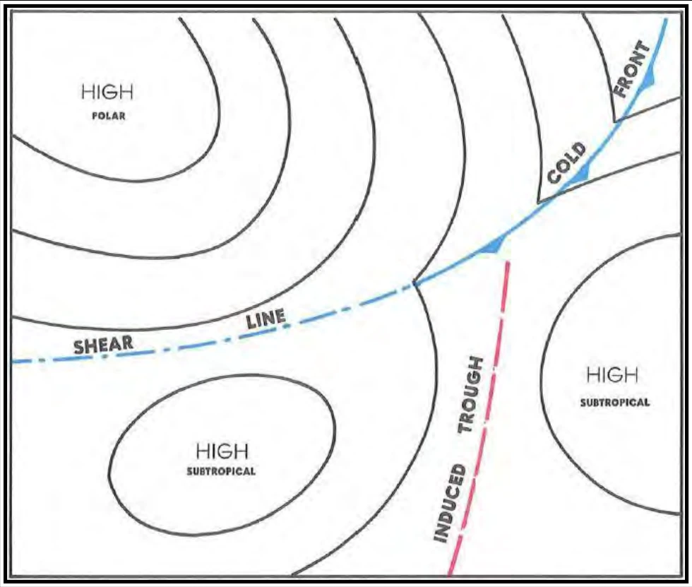
A shear line, also shown in Figure 17-3, results when a semipermanent high splits into two cells, inducing a trough. These shear lines are zones of convergence creating forced upward motion. Consequently, considerable thunderstorm and rain shower activity occurs along a shear line.