
Chapter 17
Tropical Weather
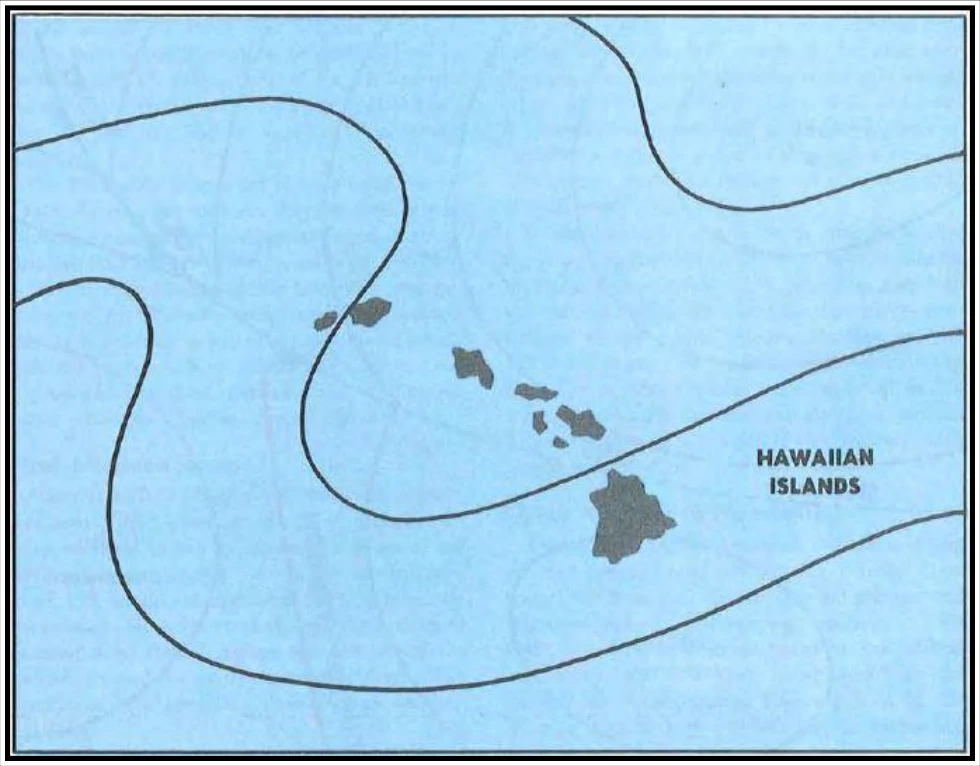
Troughs above the surface, generally at or above 10,000 ft, move through the Tropics, especially along the poleward fringes. These are known as TUTTs. Figure 17-4 shows such a trough. As a TUTT moves to the southeast or east, it spreads middle and high cloudiness over extensive areas to the east of the trough line. Occasionally, a well-developed trough will extend deep into the Tropics, and a closed low forms at the equatorial end of the trough. The low then may separate from the trough and move westward, producing a large amount of cloudiness and precipitation. If this occurs in the vicinity of a strong subtropical jet stream, extensive, and sometimes dense cirrus and some convective turbulence and CAT, often develop.
TUTTs and lows aloft produce considerable amounts of rainfall in the Tropics, especially over land areas where mountains and surface heating lift air to saturation. Low-pressure systems aloft contribute significantly to the 300+ in of annual rainfall over the higher terrain of Maui and the big island of Hawaii. Other mountainous areas of the Tropics are also among the wettest spots on Earth.
17.3.3 Tropical Wave
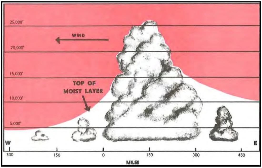
Tropical waves (also called easterly waves) are common tropical weather disturbances, normally occurring in the trade wind belt. In the Northern Hemisphere, they usually develop in the southeastern perimeter of subtropical high-pressure systems. They travel from east to west around the southern fringes of these highs in the prevailing easterly circulation of the Tropics. Surface winds in advance of a wave are somewhat more northerly than the usual trade wind direction. As shown in Figure 17-5, as the wave approaches, pressure falls; as it passes, surface wind shifts to the east-southeast or southeast. The typical wave is preceded by very good weather but followed by extensive cloudiness (see Figure 17-6), and often by rain and thunderstorms. The weather activity is roughly in a north-south line.
Tropical waves occur in all seasons but are more frequent and stronger during summer and early autumn. Pacific waves frequently affect Hawaii; Atlantic waves occasionally move into the Gulf of America, reaching the coast of the United States.
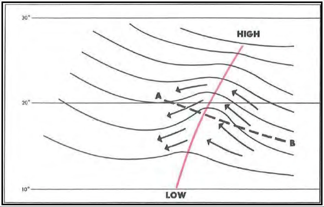
Note that winds shift generally from northeasterly to southeasterly. The wave moves toward the west and is often preceded by good weather and followed by extensive cloudiness and precipitation.
17.3.4 West African Disturbance Line (WADL)
On occasion, a line of convection similar to a squall line moves westward off the continent at tropical latitudes into the oceanic trade winds. In the North Atlantic, this is known as the West African Disturbance Line (WADL). A WADL can move faster than easterly waves at 20 to 40 mph. Some WADLs eventually develop into tropical storms or hurricanes.
17.3.5 Tropical Cyclones
“Tropical cyclone” is a general term for any low that originates over tropical oceans. Tropical cyclones are classified according to their intensity based on the average wind speeds. Wind gusts in these storms may be as much as 50 percent higher than the average wind speeds. Over the north Atlantic and northeast Pacific Oceans, tropical cyclone classifications are:
- Tropical depression—sustained winds up to 34 kt (64 km/h).
- Tropical storm—sustained winds of 35 to 64 kt (65 to 119 km/h).
- Hurricane—sustained winds of at least 65 kt (120 km/h) or more.
The NWS NHC and the CPHC use a 1-minute average wind speed for the above classifications.
In other regions of the world, a 10-minute average wind speed is used along with different terms. Tropical cyclones meeting hurricane strength in the northwest Pacific Ocean are called “typhoons,” “severe tropical cyclones” in the southwest Pacific and southeast Indian Oceans (e.g., near Australia), “severe cyclonic storms” in the north Indian Ocean, and just “tropical cyclone” in the southwest Indian Ocean. The term “super typhoon” is used if the maximum sustained winds are at least 130 kt (241 km/h).
17.3.5.1 Development
The prerequisites for tropical cyclone development are optimum sea surface temperature under low-level convergence and cyclonic wind shear. Favored breeding grounds are shear lines, TUTTs, tropical waves, and lines of convection in low latitudes moving from the continent to the tropical ocean (e.g., WADL).
The low-level convergence associated with these systems by itself will not support development of a tropical cyclone. The system must also have horizontal outflow (divergence) at high tropospheric levels. This combination creates a chimney, in which air is forced upward causing clouds and precipitation. Condensation releases large quantities of latent heat, which raises the temperature of the system and accelerates the upward motion. The rise in temperature lowers the surface pressure, which increases low-level convergence. This draws more moisture-laden air into the system. When these chain-reaction events continue, a huge vortex is generated, which may culminate in hurricane-force winds.
Figure 17-7 shows regions of the world where tropical cyclones frequently develop. They usually originate between latitudes 5° and 20°. Tropical cyclones are unlikely within five degrees of the Equator because the Coriolis force is so small near the Equator that it will not turn the winds enough for them to flow around a low-pressure area. Winds flow directly into an equatorial low and rapidly fill it.