
Chapter 18
Weather and Obstructions to Visibility
A dust storm is a severe weather condition characterized by strong winds and dust-filled air over an extensive area. Dust storms originate over regions when fine-grained soils, rich in clay and silt, are exposed to strong winds and lofted airborne. Fine-grained soils are commonly found in dry lake beds (called playas), river flood plains, ocean sediments, and glacial deposits.
Most of the dust originates from a number of discrete point sources. Intense dust storms reduce visibility to near zero in and near source regions, with visibility improving away from the source.
A dust storm is favored with extreme daytime heating of barren ground and a turbulent, unstable air mass that allows the dust to be lofted. Surface winds need to be 15 kt or greater to mobilize dust. A speed of 35 kt may be needed over a desert surface that is covered with closely packed rock fragments called desert pavement. The average height of a dust storm is 3,000–6,000 ft (about 1 km); however, they can frequently extend up to 15,000 ft (4,600 m).
Strong cooling after sunset quickly stabilizes the lowest atmosphere, forming a temperature inversion and settling the dust. Without turbulence, dust generally settles at a rate of 1,000 ft (300 m) per hour. It can take many hours (or days) for the dust to completely settle. However, precipitation will very effectively remove dust from the atmosphere.
Aircraft operation in a dust storm can be very hazardous. Visibility can drop to zero in a matter of seconds. Dust can also clog the air intake of engines, damage electro-optical systems, and cause problems with human health.
From a pilot’s point of view, it is important to recognize that slant range (air-to-ground) visibility (see Figure 24-3) in dust is generally reduced compared to reported surface (horizontal) visibility. Therefore, it may not be possible to pick out an airfield from above, even when reported surface visibility is 3 mi or more.
18.1.8 Sandstorm
A sandstorm is particles of sand carried aloft by a strong wind. The sand particles are mostly confined to the lowest 10 ft (3.5 m), and rarely rise more than 50 ft (15 m) above the ground. Sandstorms are similar to dust storms but occur on a localized scale. This is because sand particles are larger and heavier than dust particles. Sandstorms are best developed in desert regions where there is loose sand, often in dunes, without much admixture of dust.
18.1.8.1 Haboob
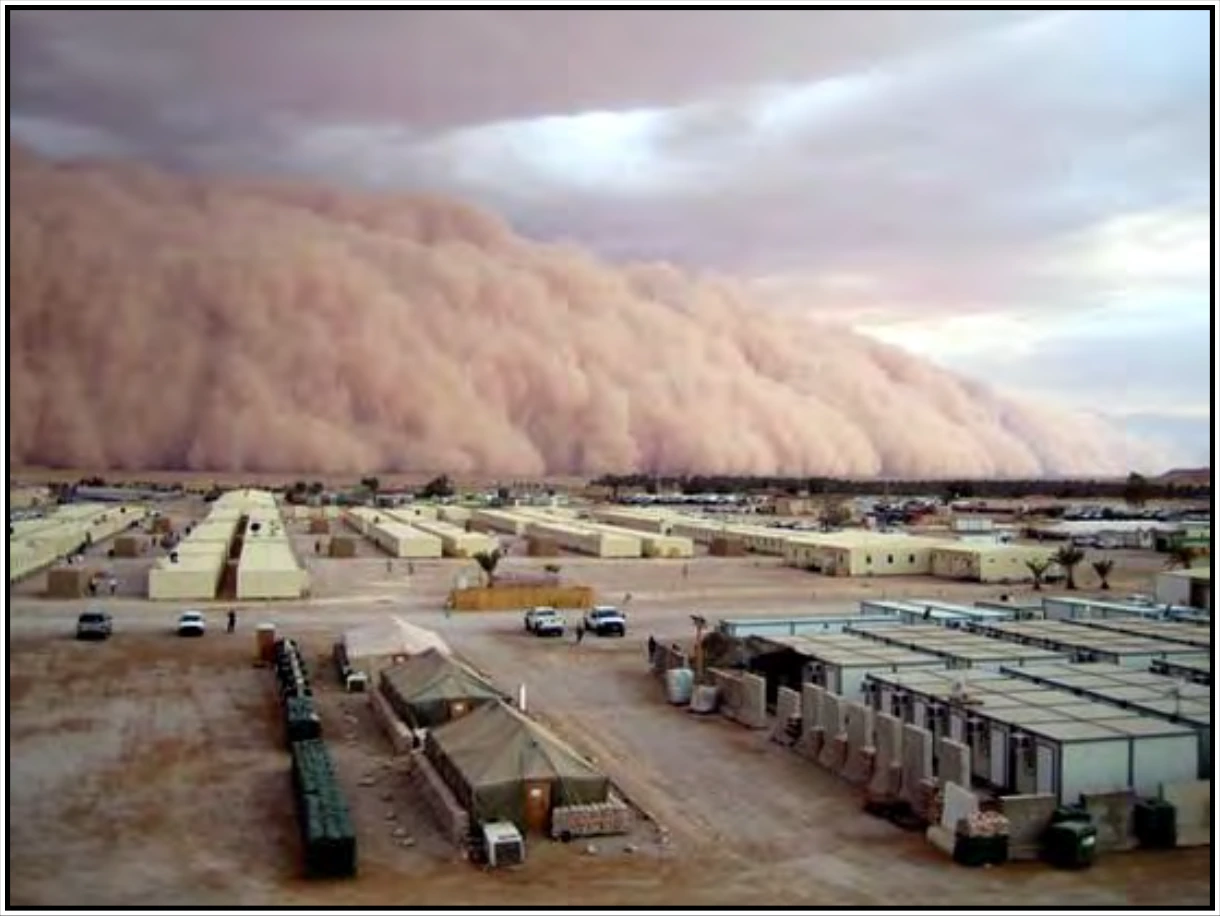
A haboob (see Figure 18-11) is a dust storm or sandstorm that forms as cold downdrafts from a thunderstorm turbulently lift dust and sand into the air. While haboobs are often short-lived, they can be quite intense. The dust wall may extend horizontally for more than 60 mi (100 km) and rise vertically to the base of the thunderstorm. Spinning whirlwinds of dust frequently form along the turbulent cold air outflow, giving rise to huge dust/sand whirls.
18.1.9 Volcanic Ash
Volcanic ash is made up of fine particles of rock powder that originate from a volcano and that may remain suspended in the atmosphere for long periods. Severe volcanic eruptions that send ash into the upper atmosphere occur somewhere around the world several times per year. The explosive eruption from the volcano in Tonga, South Pacific Ocean in January 2022 sent an ash cloud into the mesosphere. Weather satellites estimated the ash cloud reached an altitude of 190,000 ft, which was the highest ash cloud ever observed.
Visible ash is what an observer or aircrew member sees with their eyes. The lower limit of visible ash ranges from an ash concentration of approximately 0.01 milligrams per cubic meter (mg/m3) to 10 mg/m3, depending on many factors such as time of day, sky background, and position of the Sun to the observer (pilot), as well as the angle from which the ash cloud is viewed (e.g., viewed from the side).
Discernible ash is what a satellite or other remote sensing instrument detects. Forecasters at the world’s nine VAACs (see Section 26.5.1) use discernible ash from satellites to define the observed area of the ash cloud in the VAA product (see Section 26.5). The lower limit of discernible ash from satellites is approximately 0.1 to 0.2 mg/m3, depending on the satellite and other factors.
The ash cloud may not be visible, especially at night or in instrument meteorological conditions (IMC). Even if visible, it is difficult to distinguish visually between an ash cloud and an ordinary cloud. Radar may be able to detect heavy concentrations of airborne ash near the volcano, but it is not able to detect fine airborne ash and is not likely to detect the ash cloud as it spreads downwind of the volcano.
Flying into a volcanic ash cloud can be hazardous. Volcanic ash is composed of silica (glass). When ash is ingested into a jet engine, it melts to produce a soft, sticky molten product that adheres to the compressor turbine blades and fuel injectors/igniters. With no air going into the engine, the fuel cannot ignite, the engine comes to a slow spinning stop by spooling down, and a flameout occurs. As the aircraft exits the ash cloud and enters colder temperatures, the cooled, hardened silicas on the turbine blades become dislodged, allowing the fan blades to rotate, allowing for an engine relight as the air moves through the engine again. Piston-powered aircraft are less likely to lose power, but severe engine damage is likely after an encounter with a volcanic ash cloud that is only a few hours old.
Volcanic ash also causes abrasive damage to aircraft flying through it at hundreds of miles per hour. Particles impacting the windshield can sandblast the surface into a frosted finish that obscures the pilot’s view. The sandblasting can also remove paint and pit metal on the nose and leading edges of wings and navigation equipment. Ash contaminates aircraft ventilation, hydraulic, instrument, electronic, and air data systems. Ash covering a runway can cover its markings and cause aircraft to lose traction during takeoffs and landings.