
Chapter 22
Thunderstorms
Tornadoes can occur almost anywhere in the world but are most common in the central and eastern United States during spring and autumn months. They typically last only a few minutes and travel a few miles, but can persist much longer (e.g., more than 90 minutes) and track much farther (e.g., more than 100 mi), in extreme cases.
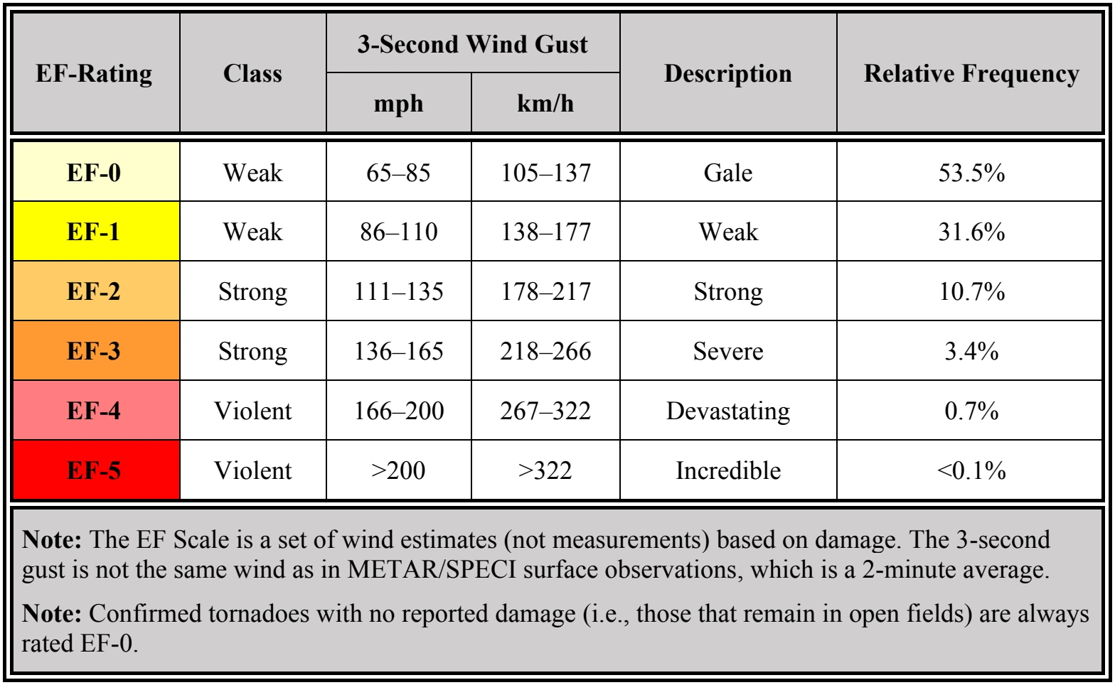
On a local scale, the tornado is the most intense of all atmospheric circulations. Its vortex is typically a few hundred yards in diameter but can range in width from less than 10 yards (yd) to over 2 mi. Wind speeds are typically estimated on the basis of wind damage using the Enhanced Fujita (EF) Scale (see Table 22-1).
Tornadoes occur with both isolated and squall line thunderstorms. However, over 80 percent of all tornadoes in the United States are produced by supercell thunderstorms. Multiple tornado occurrences associated with a particular large-scale weather system is termed a “tornado outbreak.” On rare occasions, one supercell can produce multiple tornadoes over many hours. In addition, families of tornadoes have also been observed as appendages of the main cloud extending several miles outward from the area of lightning and precipitation. Thus, any cloud connected to a severe thunderstorm may contain hidden vortices.
An aircraft entering a tornado vortex is almost certain to suffer loss of control and structural damage. Since the vortex extends well into the cloud, any pilot inadvertently caught on instruments in a thunderstorm could encounter a hidden vortex.
22.7.10 Engine Water Ingestion
Turbine engines have a limit on the amount of water they can ingest. Updrafts are present in many thunderstorms, particularly those in the developing stages. If the updraft velocity in the thunderstorm approaches or exceeds the velocity of the falling raindrops, very high concentrations of water may occur. It is possible that these concentrations can be in excess of the quantity of water that turbine engines are designed to ingest. Therefore, severe thunderstorms may contain areas of high water concentration, which could result in flameout and/or structural failure of one or more engines.
22.8 Thunderstorm Avoidance
22.8.1 Airborne Weather Avoidance Radar (Aircraft Radar)
Airborne weather avoidance radar is, as the name implies, for avoiding severe weather—not for penetrating it. Whether to fly into an area of radar echoes depends on echo intensity, spacing between the echoes, and the capabilities of the pilot and the aircraft. The ability of airborne weather radar to detect weather phenomena is limited in both direction and range. Some airborne radars are fitted with a turbulence display mode, which is based on the Doppler effect. These Doppler radars can detect turbulence associated with precipitation (sometimes referred to as wet precipitation), but these radars are unable to detect clear-air turbulence (CAT). The radar display also does not provide assurance of avoiding instrument weather conditions from clouds and fog. A phenomenon called attenuation (see Section 15.2.5) may exist when a cell absorbs or reflects all of the radio signals sent by the radar system (see Figure 15-5). Attenuation may prevent the radar from detecting additional cells that might lie behind the first cell. This is sometimes referred to as a radar “shadow.” For aircraft equipped with airborne weather radar, pilots are expected to be familiar with the operating techniques and limitations of the specific system.
It is important to note that while hail always gives a radar echo, it may fall several miles from the nearest visible cloud, and hazardous turbulence may extend to as much as 20 mi from the echo edge.
22.8.2 Thunderstorm Avoidance Guidance
Never regard any thunderstorm lightly, even when radar observers report the echoes are of light intensity. Avoiding thunderstorms is the best policy. The following is guidance for avoiding thunderstorms:
- Do not land or take off in the face of an approaching thunderstorm. A sudden gust front of low-level turbulence could cause loss of control.
- Do not attempt to fly under a thunderstorm, even if you can see through to the other side. Turbulence and wind shear under the storm could be hazardous.
- Do not attempt to fly under the anvil of a thunderstorm. There is a potential for severe and extreme CAT.
- Do not fly without airborne radar into a cloud mass containing scattered embedded thunderstorms. Scattered thunderstorms that are not embedded usually can be visually circumnavigated.
- Do not trust the visual appearance to be a reliable indicator of the turbulence inside a thunderstorm.
- Do not assume that ATC will offer radar navigation guidance or deviations around thunderstorms.
- Do not use data-linked weather radar (i.e., NEXRAD) mosaic imagery as the sole means for negotiating a path through a thunderstorm area (tactical maneuvering).
- Remember that the data-linked NEXRAD mosaic imagery shows where the weather was, not where the weather is. The weather conditions may be 15–20 minutes older than the age indicated on the display.
- Listen to chatter on the ATC frequency for PIREPs and other aircraft requesting to deviate or divert.
- Ask ATC for radar navigation guidance or to approve deviations around thunderstorms, if needed.
- Use data-linked weather NEXRAD mosaic imagery (e.g., FIS-B) for route selection to avoid thunderstorms entirely (strategic maneuvering).
- Advise ATC, when switched to another controller, that you are deviating for thunderstorms before accepting to rejoin the original route.
- Ensure that after an authorized weather deviation, before accepting to rejoin the original route, the route of flight is clear of thunderstorms.
- Avoid by at least 20 mi any thunderstorm identified as severe or giving an intense, heavy, or extreme radar echo. This is especially true under the anvil of a large cumulonimbus. Such echoes should be separated by at least 40 mi before flying between echoes. Separation distances may be reduced for avoiding weaker echoes.
- Circumnavigate the entire area if more than half the area is covered by thunderstorms.
- Vivid and frequent lightning indicates the probability of a severe thunderstorm.
- Regard as extremely hazardous any thunderstorm with tops 35,000 ft or higher, whether the top is visually sighted or determined by radar.
- Give a PIREP for the flight conditions.
- Divert and wait out the thunderstorms on the ground if unable to navigate around an area of thunderstorms.
If unable to avoid penetrating a thunderstorm, the following is guidance for before entering the storm:
- Tighten the safety belt, put on the shoulder harness (if installed), and secure all loose objects.
- Plan and hold the course to take the aircraft through the storm in a minimum time.
- To avoid the most critical icing, establish a penetration altitude below the freezing level or above the level of -15 °C.
- Verify that pitot heat is on and turn on carburetor heat or jet engine anti-ice. Icing can be rapid at any altitude and cause almost instantaneous power failure and/or loss of airspeed indication.
- Establish power settings for turbulence penetration airspeed recommended in the aircraft manual.
- Turn up cockpit lights to highest intensity to lessen temporary blindness from lightning.
- If using automatic pilot, disengage Altitude Hold Mode and Speed Hold Mode. The automatic altitude and speed controls will increase maneuvers of the aircraft; thus, increasing structural stress.
- If using airborne radar, tilt the antenna up and down occasionally. This will permit the detection of other thunderstorm activity at altitudes other than the one being flown.
- Keep eyes on the flight instruments. Looking outside the cockpit can increase danger of temporary blindness from lightning.
- Do not change power settings; maintain settings for the recommended turbulence penetration airspeed.
- Maintain constant attitude. Allow the altitude and airspeed to fluctuate.
- Do not turn back once in the thunderstorm. A straight course through the storm most likely will get the aircraft out of the hazards most quickly. In addition, turning maneuvers increase stress on the aircraft.