
Chapter 3
Arrivals
Pilots may accept a STAR within a clearance or they may file for one in their flight plan. As the aircraft nears its destination airport, ATC may add a STAR procedure to its original clearance. Keep in mind that ATC can assign a STAR even if the aircrew has not requested one. Use of a STAR requires pilot possession of at least the approved chart. RNAV STARs must be retrievable by the procedure name from the aircraft database and conform to charted procedure. If an aircrew does not want to use a STAR, they must specify “No STAR” in the remarks section of their flight plan. Pilots may also refuse the STAR when it is given to them verbally by ATC, but the system works better if the aircrew advises ATC ahead of time.
Preparing for the Arrival
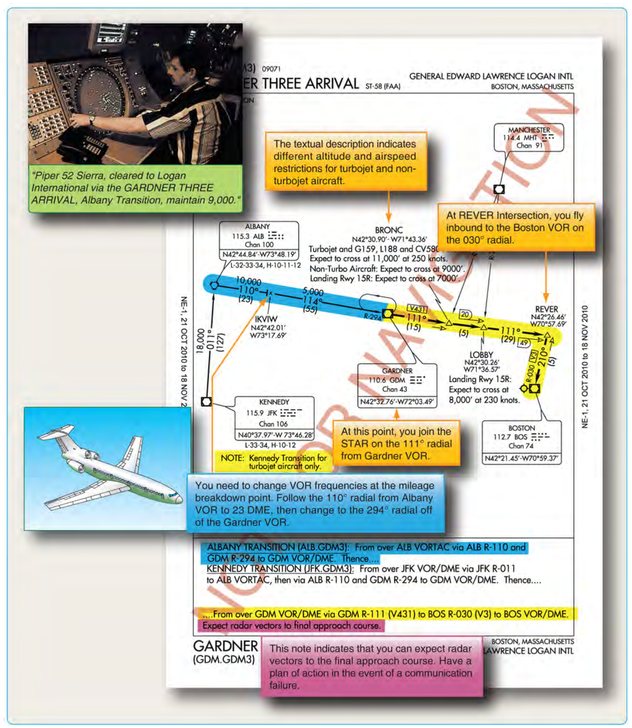
As mentioned before, STARs include navigation fixes that are used to provide transition and arrival routes from the en route structure to the final approach course. They also may lead to a fix where radar vectors are provided to intercept the final approach course. Pilots may have noticed that minimum crossing altitudes and airspeed restrictions appear on some STARs. These expected altitudes and airspeeds are not part of the clearance until ATC includes them verbally. A STAR is simply a published routing; it does not have the force of a clearance until issued specifically by ATC. For example, minimum en route altitude (MEAs) printed on STARs are not valid unless stated within an ATC clearance or in cases of lost communication. After receiving the arrival clearance, the aircrew should review the assigned STAR procedure and ensure the FMS has the appropriate procedure loaded (if so equipped). Obtain the airport and weather information as early as practical. It is recommended that pilots have this information prior to flying the STAR. If you are landing at an airport with approach control services that has two or more published instrument approach procedures, you will receive advance notice of which instrument approaches to expect. This information is broadcast either by ATIS or by a controller. [Figure 3-14] It may not be provided when the visibility is 3 SM or better and the ceiling is at or above the highest initial approach altitude established for any instrument approach procedure for the airport.
For STAR procedures charted with radar vectors to the final approach, look for routes from the STAR terminating fixes to the IAF. If no route is depicted, you should have a predetermined plan of action to fly from the STAR terminating fix to the IAF in the event of a communication failure.
Reviewing the Approach
Once the aircrew has determined which approach to expect, review the approach chart thoroughly before entering the terminal area. Aircrews should check fuel level and make sure a prolonged hold or increased headwinds have not cut into the aircraft’s fuel reserves because there is always a chance the pilot has to make a missed approach or go to an alternate. By completing landing checklists early, aircrews can concentrate on the approach.
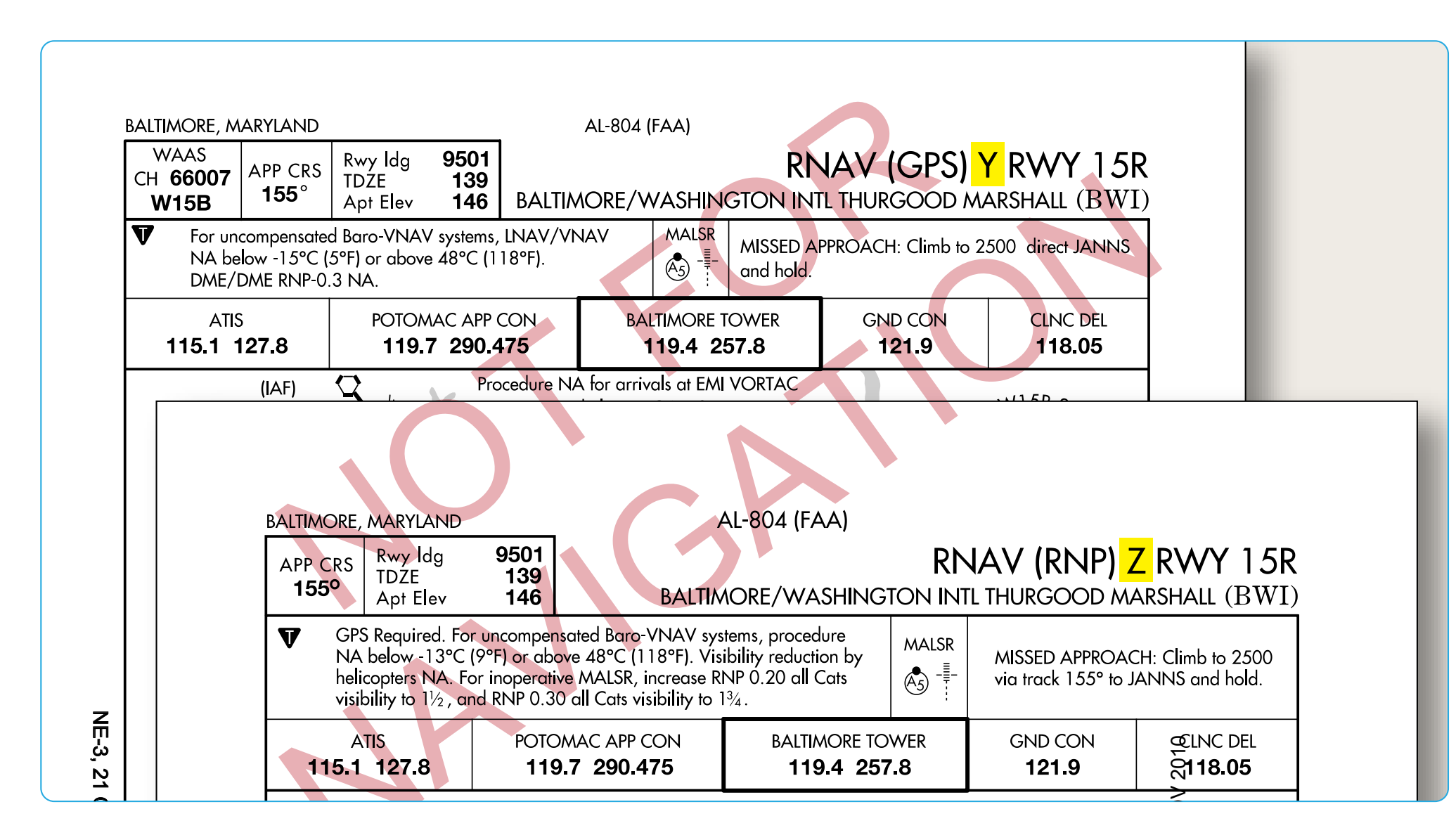
In setting up for the expected approach procedure when using an RNAV, GPS, or FMS system, it is important to understand how multiple approaches to the same runway are coded in the database. When more than one RNAV procedure is issued for the same runway, there must be a way to differentiate between them within the equipment’s database, as well as to select which procedure is to be used. (Multiple procedures may exist to accommodate GPS receivers and FMS, both with and without VNAV capability.) Each procedure name incorporates a letter of the alphabet, starting with Z and working backward through Y, X, W, and so on. (Naming conventions for approaches are covered in more depth in the next chapter). [Figure 3-15]
Altitude
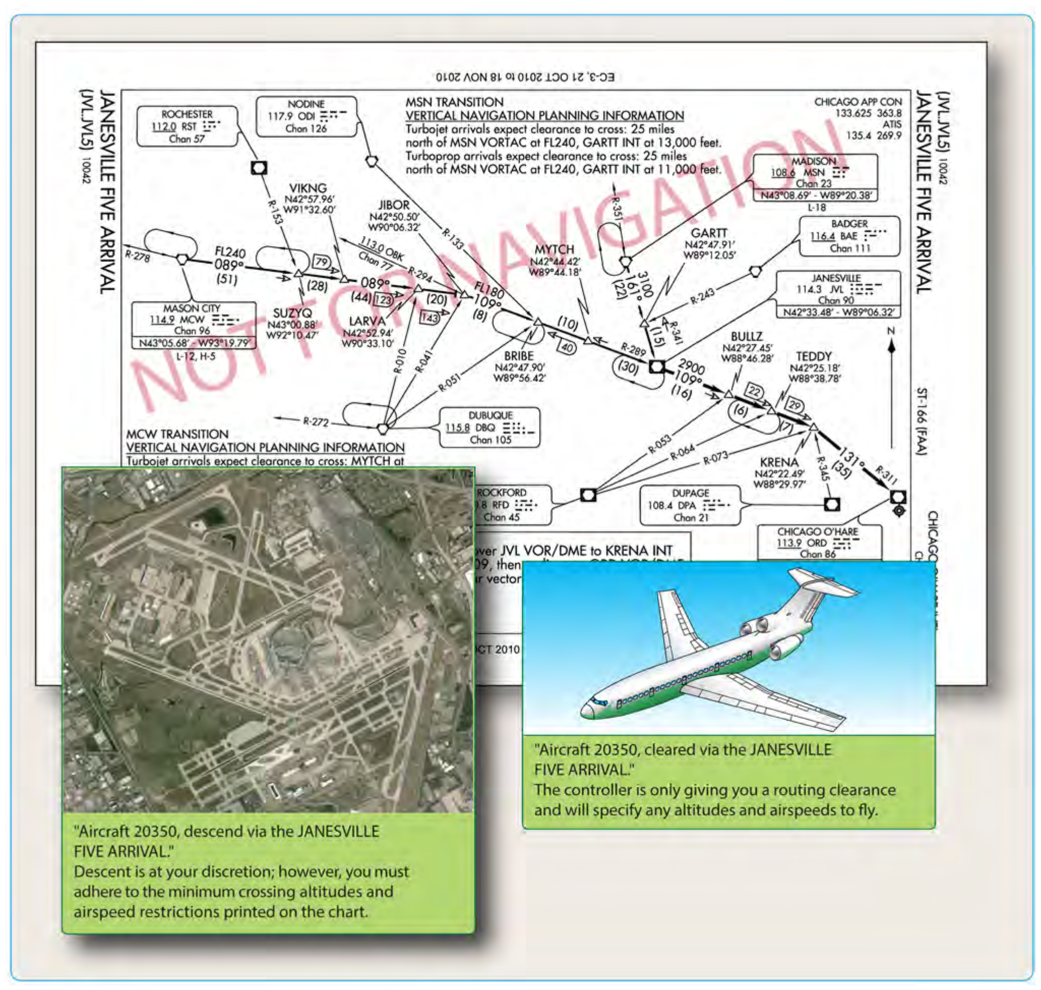
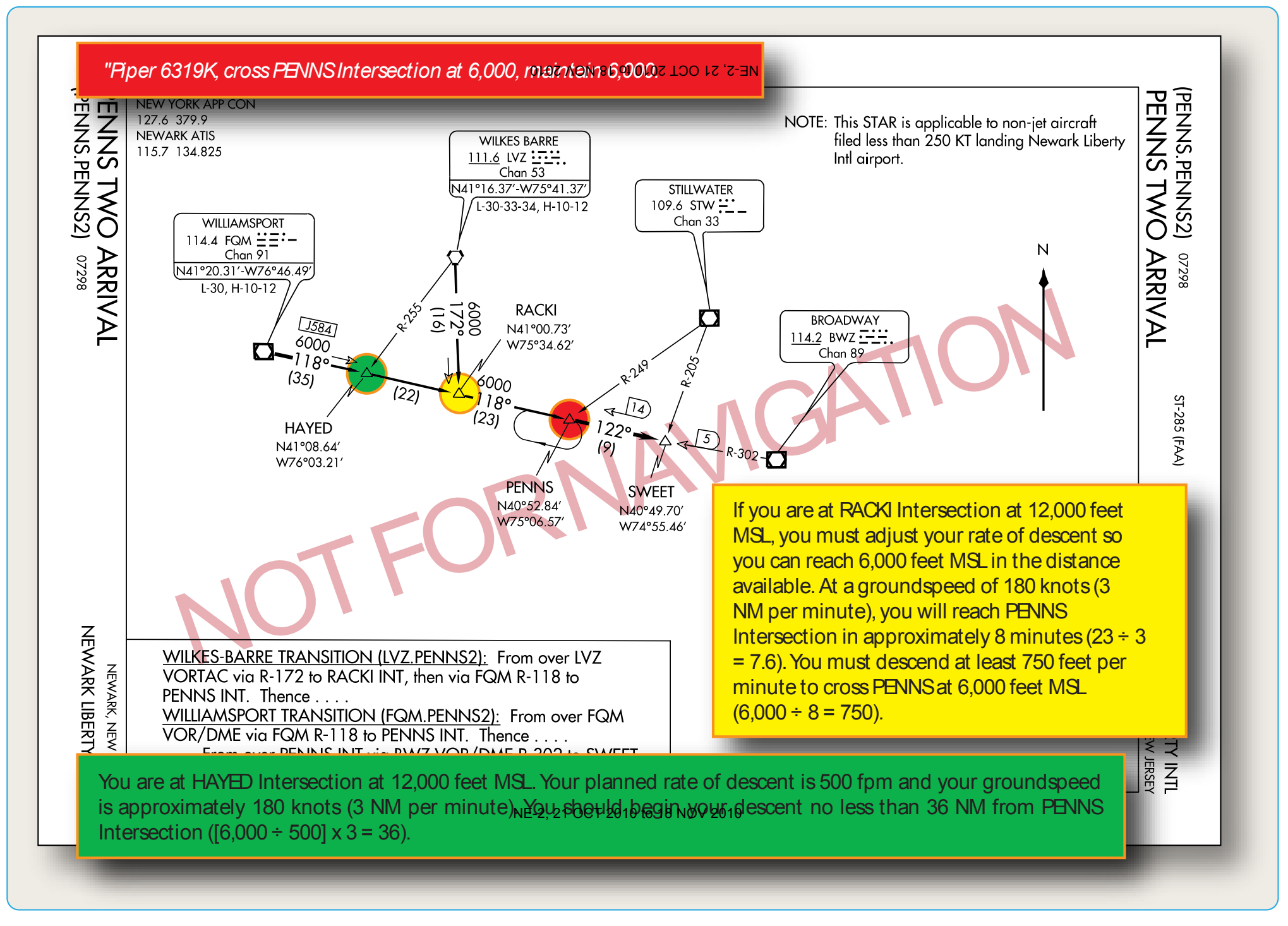
Upon arrival in the terminal area, ATC either clears the aircraft to a specific altitude, or they give it a “descend via” clearance that instructs the pilot to follow the altitudes published on the STAR. [Figure 3-16] Pilots are not authorized to leave their last assigned altitude unless specifically cleared to do so. If ATC amends the altitude or route to one that is different from the published procedure, the rest of the charted descent procedure is canceled. ATC assigns any further route, altitude, or airspeed clearances, as necessary. Notice the JANESVILLE FOUR ARRIVAL depicts only one published arrival route, with no named transition routes leading to the basic STAR procedure beginning at the Janesville VOR/DME. VNAV planning information is included for turbojet and turboprop aircraft at the bottom of the chart. Additionally, note that there are several ways to identify the BRIBE reporting point using alternate formation radials, some of which are from off- chart NAVAIDs. ATC may issue a descent clearance that includes a crossing altitude restriction. In the PENNS ONE ARRIVAL, the ATC clearance authorizes aircraft to descend at the pilots’ discretion, as long as the pilot crosses the PENNS Intersection at 6,000 feet MSL. [Figure 3-17]
In the United States, Canada, and many other countries, the common altitude for changing to the standard altimeter setting of 29.92 inches of mercury ("Hg) (or 1013.2 hectopascals or millibars) when climbing to the high altitude structure is 18,000 feet. When descending from high altitude, the altimeter should be changed to the local altimeter setting when passing through FL 180, although in most countries throughout the world the change to or from the standard altimeter setting is not done at the same altitude for each instance.
For example, the flight level where aircrews change their altimeter setting to the local altimeter setting is specified by ATC each time they arrive at a specific airport. This information is shown on STAR charts outside the United States with the words: TRANS LEVEL: BY ATC. When departing from that same airport (also depicted typically on the STAR chart), the altimeter should be set to the standard setting when passing through 5,000 feet, as an example. This means that altimeter readings when flying above 5,000 feet are actual flight levels, not feet. This is common for Europe, but very different for pilots experienced with flying in the United States and Canada.
Although standardization of these procedures for terminal locations is subject to local considerations, specific criteria apply in developing new or revised arrival procedures. Normally, high performance aircraft enter the terminal area at or above 10,000 feet above the airport elevation and begin their descent 30 to 40 NM from touchdown on the landing runway. Unless pilots indicate an operational need for a lower altitude, descent below 5,000 feet above the airport elevation is typically limited to an altitude where final descent and glideslope/glidepath intercept can be made without exceeding specific obstacle clearance and other related arrival, approach, and landing criteria. Arrival delays typically are absorbed at a metering fix. This fix is established on a route prior to the terminal airspace, 10,000 feet or more above the airport elevation. The metering fix facilitates profile descents, rather than controllers using delaying vectors or a holding pattern at low altitudes. Descent restrictions normally are applied prior to reaching the final approach phase to preclude relatively high descent rates close in to the destination airport. At least 10 NM from initial descent from 10,000 feet above the airport elevation, the controller issues an advisory that details when to expect to commence the descent. ATC typically uses the phraseology, “Expect descent in (number) miles.” Standard ATC phraseology is, “Maintain (altitude) until specified point (e.g., abeam landing runway end), cleared for visual approach or expect visual or contact approach clearance in (number of miles, minutes, or specified point).”
Once the determination is made regarding the instrument approach and landing runway pilots use, ATC will not permit a change to another NAVAID that is not aligned with the landing runway. When altitude restrictions are required for separation purposes, ATC avoids assigning an altitude below 5,000 feet above the airport elevation.
There are numerous exceptions to the high performance aircraft arrival procedures previously outlined. For example, in a non-radar environment, the controller may clear the flight to use an approach based on a NAVAID other than the one aligned with the landing runway, such as a circling approach. In this case, the descent to a lower altitude usually is limited to the circling approach area with the circle-to-land maneuver confined to the traffic pattern.
IFR en route descent procedures should include a review of minimum, maximum, mandatory, and recommended altitudes that normally precede the fix or NAVAID facility to which they apply. The initial descent gradient for a low altitude instrument approach procedure does not exceed 500 ft/NM (approximately 5°), and for a high altitude approach, the maximum allowable initial gradient is 1,000 ft/NM (approximately 10°).
Remember during arrivals, when cleared for an instrument approach, maintain the last assigned altitude until established on a published segment of the approach or on a segment of a published route. If no altitude is assigned with the approach clearance and the aircraft is already on a published segment, the pilot can descend to its minimum altitude for that segment of the approach.