
Chapter 4
Approaches
Like flying any other IAP, the pilot must see and avoid any obstacles in the visual segment during transition to landing. A constant-rate descent has many safety advantages over non-precision approaches that require multiple level-offs at stepdown fixes or manually calculating rates of descent. A stabilized approach can be maintained from the FAF to the landing when a constant-rate descent is used. Additionally, the use of an electronic vertical path produced by onboard avionics can serve to reduce CFIT, and minimize the effects of visual illusions on approach and landing. Some countries even mandate the use of continuous descent final approaches (CDFAs) on non-precision approaches.
Wide Area Augmentation System
The Wide Area Augmentation System (WAAS) offers an opportunity for airports to gain ILS like approach capability without the purchase or installation of any ground-based navigation equipment at the airport. Today, WAAS is already being used at more than 900 runways across the United States to achieve minimums as low as 200 feet height above HAT/one-half mile visibility.
Benefits Of WAAS In The Airport Environment
WAAS is a navigation service using a combination of GPS satellites and the WAAS geostationary satellites to improve the navigational service provided by GPS. WAAS achieved initial operating capability (IOC) in 2003. The system is owned and operated by the FAA and provided free of direct user charges to users across the United States and most of Canada and Mexico.
WAAS improves the navigational system accuracy for en route, terminal, and approach operations over all the continental United States and significant portions of Alaska, Canada, and Mexico. This new navigational technology supports vertically-guided instrument approaches to all qualifying runways in the United States. Vertically-guided approaches reduce pilot workload and provide safety benefits compared to non-precision approaches. The WAAS enabled vertically guided approach procedures are called LPV, which stands for “localizer performance with vertical guidance,” and provide ILS equivalent approach minimums as low as 200 feet at qualifying airports. Actual minimums are based on an airport’s current infrastructure, as well as an evaluation of any existing obstructions. The FAA plans to publish 300 WAAS approach procedures per year to provide service to all qualifying instrument runways within the NAS.
Advantages Of WAAS Enabled LPV Approaches
The advantages of WAAS enabled LPV approaches include:
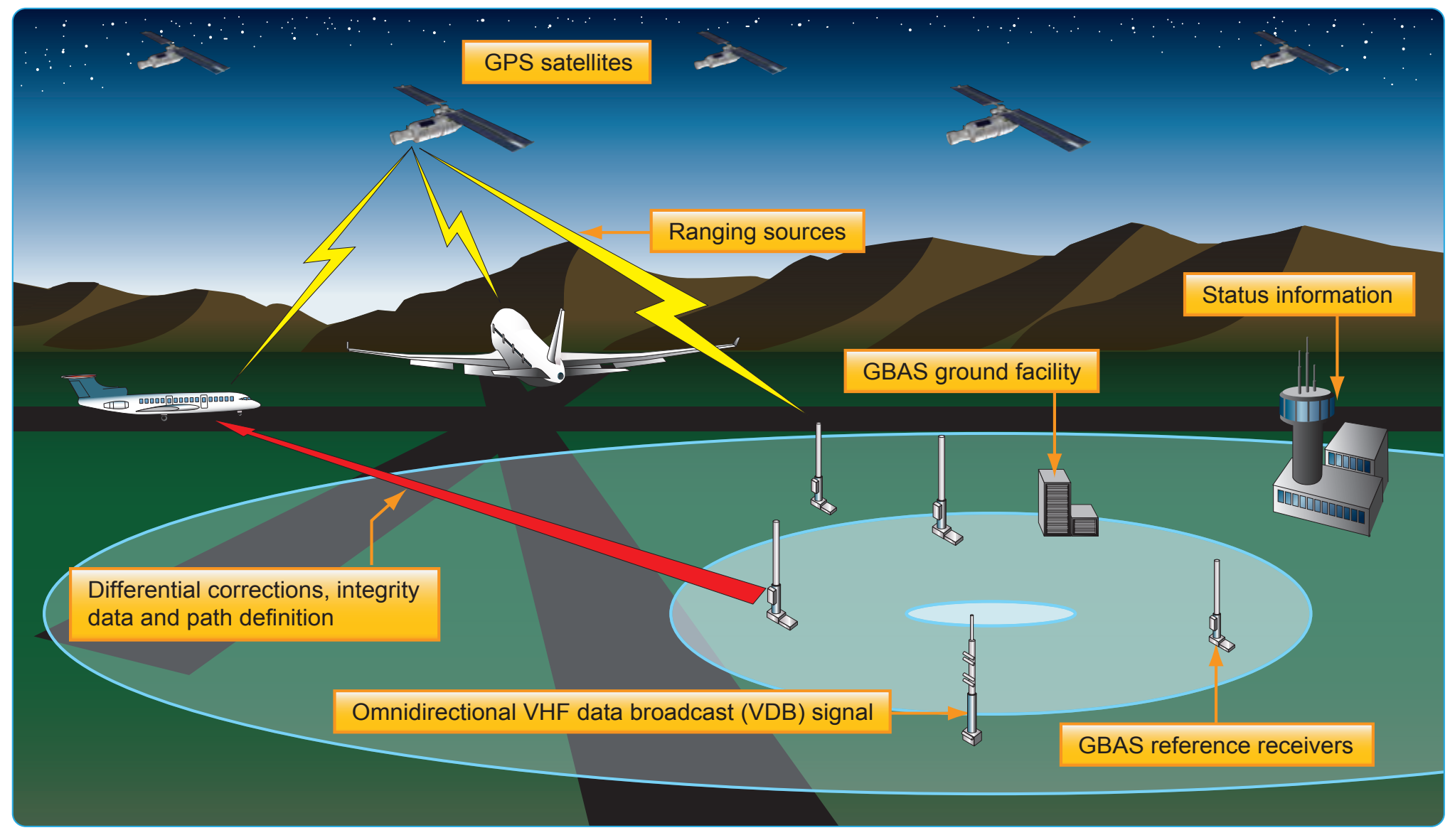
- LPV procedures have no requirement for ground-based transmitters at the airport.
- No consideration needs to be given to the placement of navigation facility, maintenance of clear zones
around the facility, or access to the facility for maintenance.
- LPV approaches eliminate the need for critical area limitations associated with an ILS.
- From a pilot’s viewpoint, an LPV approach looks and flies like an ILS, but the WAAS approach is more stable than that of an ILS.
- WAAS equipped users can fly RNAV and basic required navigation performance (RNP) procedures, as well as LPV procedures, and the avionics costs are relatively inexpensive considering the total navigation solution provided.
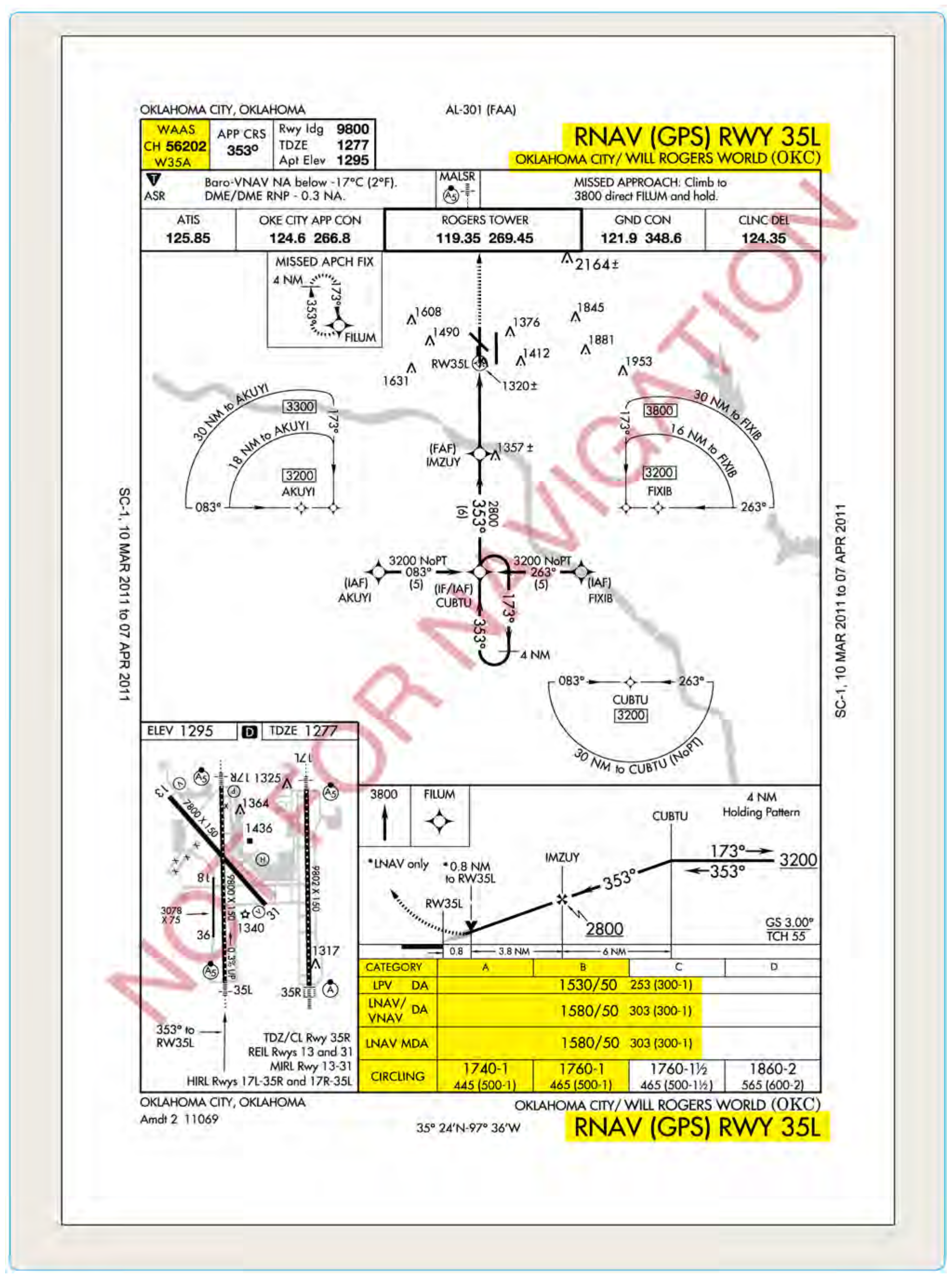
RNAV (GPS) approach charts normally have four lines of approach minimums: LPV, LNAV/VNAV, LNAV, and Circling. Figure 4-12 shows how these minimums might be presented on an approach chart, with the exception of Ground Based Augmentation System (GBAS) Landing System (GLS). This enables as many GPS equipped aircraft to use the procedure as possible and provides operational flexibility if WAAS becomes unavailable. Some aircraft may only be equipped with GPS receivers so they can fly to the LNAV MDA. Some aircraft equipped with GPS and FMS (with approach-certified barometric vertical navigation, or Baro-VNAV) can fly to the LNAV/VNAV MDA. Flying a WAAS LPV approach requires an aircraft with WAAS-LPV avionics. If for some reason the WAAS service becomes unavailable, all GPS or WAAS equipped aircraft can revert to the LNAV MDA and land safely using GPS only, which is available nearly 100 percent of the time. Some locations will have an LP line of minima on an RNAV (GPS) approach chart; but the use of LP is being phased out. At locations with obstacle penetrations in the missed approach segment, there might be two lines of minima for the same type of navigation- one line with higher approach minima without a specified climb gradient and another line with lower approach minima with a specified climb gradient in the event of missed approach.
LPV identifies WAAS approach with vertical guidance (APV) approach minimums with electronic lateral and vertical guidance capability. LPV is used for approaches constructed with WAAS criteria where the value for the vertical alarm limit is more than 12 meters and less than 50 meters. WAAS avionics equipment approved for LPV approaches is required for this type of approach. The lateral guidance is equivalent to localizer accuracy, and the protected area is considerably smaller than the protected area for the present LNAV and LNAV/VNAV lateral protection. Aircraft can fly this minima line with a statement in the AFM that the installed equipment supports LPV approaches. In Figure 4-12, notice the WAAS information shown in the top left corner of the pilot briefing information on the chart depicted. Below the term WAAS is the WAAS channel number (CH 56202), and the WAAS approach identifier (W35A), indicating Runway 35L in this case, and then a letter to designate the first in a series of procedures to that runway [Figure 4-12].
LNAV/VNAV identifies APV minimums developed to accommodate an RNAV IAP with vertical guidance, usually provided by approach certified Baro-VNAV, but with vertical and lateral integrity limits larger than a precision approach or LPV. Many RNAV systems that have RNP 0.3 or less approach capability are specifically approved in the AFM. Airplanes that are commonly approved in these types of operations include Boeing 737NG, 767, and 777, as well as the Airbus A300 series. Landing minimums are shown as DAs because the approaches are flown using an electronic glide path. Other RNAV systems require special approval. In some cases, the visibility minimums for LNAV/VNAV might be greater than those for LNAV only. This situation occurs because DA on the LNAV/VNAV vertical descent path is farther away from the runway threshold than the LNAV MDA missed approach point.
Also shown in Figure 4-12, is the LNAV minimums line. This minimum is for lateral navigation only, and the approach minimum altitude is published as a MDA. LNAV provides the same level of service as the present GPS stand alone approaches. LNAV supports the following systems: WAAS, when the navigation solution will not support vertical navigation; and GPS navigation systems which are presently authorized to conduct GPS approaches.
Circling minimums that may be used with any type of approach approved RNAV equipment when publication of straight-in approach minimums is not possible.