Helicopter Route Chart airports, radio aids, airspace, navigation, procedure, and cultural symbols.
Airport Data Grouping
Boxed airport name indicates airport for which a Special Traffic Rule has been established.
(Pvt): Non-public use having landmark value.
“OBJECTIONABLE”: This airport may adversely affect airspace use.
Flight Service Station on field
Helicopter airport-data symbols — FSS, NO SVFR, FAR 93 indicator, FAA/ICAO location identifiers, control-tower frequency, part-time star — source page 50.
Airspace where fixed wing special visual flight rules operations are prohibited (shown above airport name) FAR 91
Indicates FAR 93 Special Air Traffic Rules and Airport Traffic
Location Idendtifier
ICAO Location Identifier
Control Tower (CT) - primary frequency
Star indicates operation part-time. See tower frequencies tabulation for hours of operation
When lighting is lacking, the respective character is replaced by a dash.
Lighting codes refer to runway edge lights and may not represent the longest runway or full length lighting. Dashes are not shown on heliports or helipads unless additional information follows the elevation (e.g. UNICOM, CTAF).
HELICOPTER ROUTE CHARTS GENERAL INFORMATION Helicopter Route Charts are three-color charts that depict current aeronautical information useful to helicopter pilots navigating in areas with high concentrations of helicopter activity. Information depicted includes helicopter routes, four classes of heliports with associated frequency and lighting capabilities, NAVAIDS, and obstructions. In addition, pictorial symbols, roads, and easilyidentified geographical features are portrayed. The scale is 1:125,000. These charts are updated every 56 days. Landplane All recognizable runways, including some that may be closed, are shown for visual identification. Public Private Unverified Abandoned Foreign Seaplane Heliport Heliports public and private Medical Center Helipads located at major airports (when requested) Ultralight Flight Park Foreign Airport Note NOTE: Airports outside the U.S. Flight Information Region (FIR) are shown with the standard symbol. Only the airport names and ICAO identifiers are shown. Airport Data Grouping Boxed airport name indicates airport for which a Special Traffic Rule has been established. (Pvt): Non-public use having landmark value. “OBJECTIONABLE”: This airport may adversely affect airspace use. Flight Service Station on field Airspace where fixed wing special visual flight rules operations are prohibited (shown above airport name) FAR 91 Indicates FAR 93 Special Air Traffic Rules and Airport Traffic Location Idendtifier ICAO Location Identifier Control Tower (CT) - primary frequency Star indicates operation part-time. See tower frequencies tabulation for hours of operation Automated Terminal Information Service Automated Surface Weather Observing Systems (shown when full-time ATIS is not available). Some ASOS/AWOS facilities may not be located at airports. Elevation in feet Lighting in operation Sunset to Sunshine Lighting limitations exists, refer to Chart Supplement UNICOM - Aeronautical advisory station Follows the Common Traffic Advisory Frequency (CTAF) nverified Heliport Airport of Entry Weather Camera When lighting is lacking, the respective character is replaced by a dash. Lighting codes refer to runway edge lights and may not represent the longest runway or full length lighting. Dashes are not shown on heliports or helipads unless additional information follows the elevation (e.g. UNICOM, CTAF). AIRPORTS
Source page 51
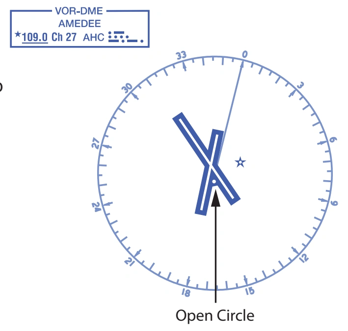
RADIO AIDS TO NAVIGATION
Open circle symbol shown when NAVAID located on airport. Type of NAVAID shown in top of box. — source page 51.
Open circle symbol shown when NAVAID located on airport. Type of NAVAID shown in top of box.
Compass Rose is “reference” oriented to magnetic north.
Cookie Preferences
We use cookies to operate this website, improve performance, understand site traffic, and personalize your experience. Essential cookies are always active because they are required for the website to function.
Required for basic site functionality and security.
Help us understand how visitors use the website so we can improve it.
May be used for advertising, remarketing, or social media features.
You can update your choices anytime using Cookie Settings. View Privacy Policy