Helicopter Route Chart airports, radio aids, airspace, navigation, procedure, and cultural symbols.
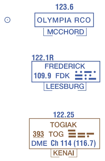
Remote Communications Outlet (RCO)
Frequencies above thin line box — source page 51.
Frequencies above thin line box
are remoted to NAVAID site.
Other FSS frequencies providing voice communications may be available as determined by altitude and terrain. Consult Chart Supplement for complete information.
Thin line box without frequencies and controlling FSS name indicates no FSS frequency available.
RADIO AIDS TO NAVIGATION NAVAIDs VHF Omni-Directional Radio (VOR) Range Open Circle Open circle symbol shown when NAVAID located on airport. Type of NAVAID shown in top of box. Compass Rose is “reference” oriented to magnetic north. VOR Operates less than contiuous or On-Request Underline indicates no voice on this frequency VORTAC ASOS/AWOS Frequency Channel Identi/f_ier } Morse Code NDB Frequency Weather CameraWhen an NDB NAVAID shares the same name and Morse Code as the VOR NAVAID the frequency can be collocated inside the same box to conserve space. VOR-DME Crosshatch indicates Shutdown status DME Flight Service Station (FSS) Heavy line box indicates Flight Service Station (FSS). Frequencies 121.5, 122.2 and 243.0 are available at many Alaskan FSSs and are not shown above boxes. All other frequencies are shown. Certain FSSs provide Airport Advisory Service, refer to Chart Supplement. R - Receive Only Non-Directional Radio Beacon (NDB) NDB-DME NAVAID Used to Define Class B Airspace Broadcast Stations (BS) On request by the proper authority or when a VFR Checkpoint. Remote Communications Outlet (RCO) Frequencies above thin line box are remoted to NAVAID site. Other FSS frequencies providing voice communications may be available as determined by altitude and terrain. Consult Chart Supplement for complete information. Thin line box without frequencies and controlling FSS name indicates no FSS frequency available.
Source page 52
AIRSPACE INFORMATION
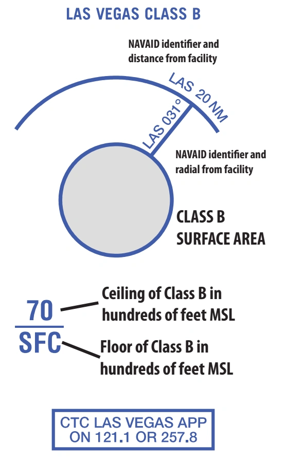
Class B Airspace
Appropriate notes as required may be shown. (Mode C see FAR 91.215/AIM) — source page 52.
Appropriate notes as required may be shown. (Mode C see FAR 91.215/AIM)
All mileages are nautical (NM)
(Floors extending “upward from above” a certain altitude are
preceded by a +. Operations at and below these altitudes are outside of Class B Airspace.)
All radials are magnetic.
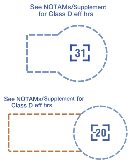
Class D Airspace
(A minus in front of the figure is used to indicate “from surface to but not including...”) — source page 52.
(A minus in front of the figure is used to indicate “from surface to but not including...”)
Altitudes in hundreds of feet MSL.
Cookie Preferences
We use cookies to operate this website, improve performance, understand site traffic, and personalize your experience. Essential cookies are always active because they are required for the website to function.
Required for basic site functionality and security.
Help us understand how visitors use the website so we can improve it.
May be used for advertising, remarketing, or social media features.
You can update your choices anytime using Cookie Settings. View Privacy Policy