Searchable explanations of IFR enroute airports, radio aids, airspace, airways, foreign areas, and terrain contours.
Airport Data Depiction
Low Altitude
1. Airport elevation given in feet above or below mean sea level
2. Pvt - Private use, not available to general public
3. A solid line box enclosed the airport name indicates FAR 93 Special Requirements - see Directory/Supplement
4. “NO SVFR” above the airport name indicates FAR 91 fixed-wing special VFR flight is prohibited.
5. “C” or “D” following the airport identifier indicates Class C or Class D Airspace
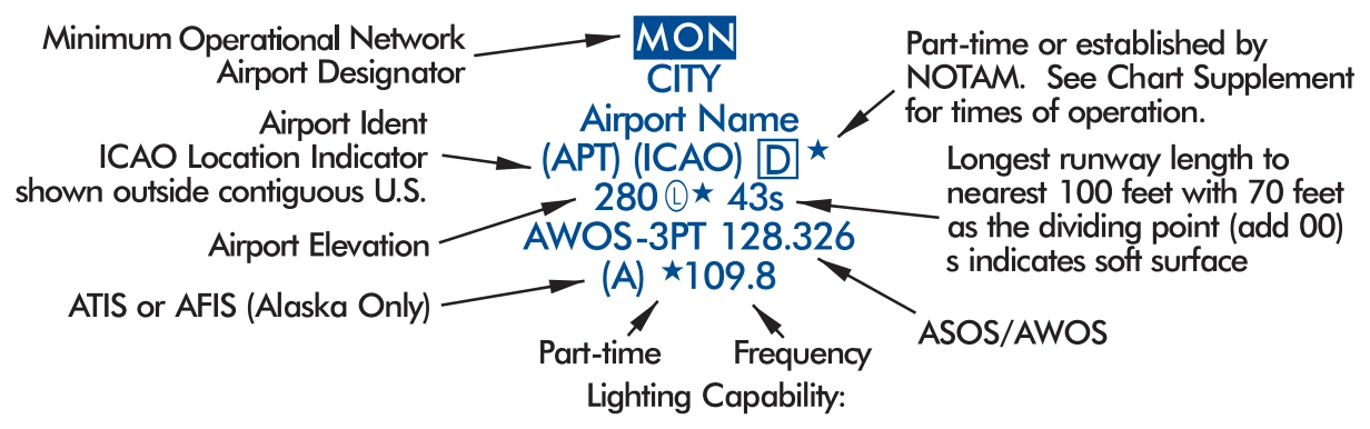
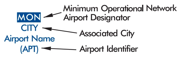
High Altitude - U.S. | 6. Associated city names for public airports are shown above or preceding the airport name. If airport name and city name are the same, only the airport name is shown. The airport identifier in parentheses follows the airport name. City names for military and private airports are not shown.
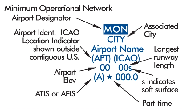
7. Airport Ident ICAO Location Indicator shown outside contiguous U.S.
8. AFIS Alaska only
High Altitude - Alaska
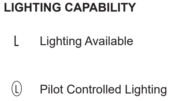
LIGHTING CAPABILITY
L — Lighting Available
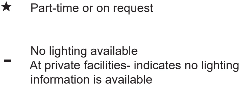
Circled L — Pilot Controlled Lighting | Star — Part-time or on request
Dash — No lighting available
At private facilities - indicates no lighting information is available
AIRPORT DATA DEPICTION
Low Altitude
1. Airport elevation given in feet above or below mean sea level2. Pvt - Private use, not available to general public3. A solid line box enclosed the airport name indicates FAR 93 Special Requirementssee Directory/Supplement4. “NO SVFR” above the airport name indicates FAR 91 fixed-wing special VFR flight is… — source page 64.
C — Class C airspace indicator following an airport identifier — source page 64.
D — Class D airspace indicator following an airport identifier — source page 64.
AIRPORT DATA DEPICTION
Low Altitude
1. Airport elevation given in feet above or below mean sea level2. Pvt - Private use, not available to general public3. A solid line box enclosed the airport name indicates FAR 93 Special Requirementssee Directory/Supplement4. “NO SVFR” above the airport name indicates FAR 91 fixed-wing special VFR flight is… — source page 64.
High-altitude Alaska Airport Data Depiction callouts — source page 64.
Airport-lighting-capability legend — lighting available / pilot-controlled lighting — source page 64.
Circled L — pilot-controlled airport lighting — source page 64.
Star — airport lighting available part-time or on request — source page 64.
Part-time/on-request star and no-lighting dash — source page 64.
A symbol between the airport elevation and runway length means that runway lights are in operation sunset to sunrise. A symbol indicates there is Pilot Controlled Lighting. A symbol means the lighting is part-time or on request, the pilot should consult the Chart Supplement for light operating procedures. The Aeronautical Information Manual (AIM) thoroughly explains the types and uses of airport lighting aids.
Blue L — airport lighting available — source page 64.
Circled L — pilot-controlled airport lighting — source page 64.
Blue L-star — lighting part-time or on request — source page 64.
VOR Minimum Operational Network (MON) Airports Designator
MON Airports with the Airport designator at the top of the Airport Data Block. The MON designation is to alert pilots to those airports that have retained ILS and VOR instrument approach procedures for safe recovery in the event of a GPS outage. Refer to the Aeronautical Information Manual (AIM) for expanded MON Airport guidance.
Minimum Operational Network airport designator — source page 64.
Airports marked "Pvt" immediately following the airport name are not for public use, but otherwise meet the criteria for charting as specified above. Runway length is the length of the longest active runway (including displaced thresholds but excluding overruns) and is shown to the nearest 100 feet using 70 feet as the division point; e.g., a runway of 8,070' is labeled 81. The following runway compositions (materials) constitute a hard-surfaced runway: asphalt, bitumen, chip seal, concrete, and tar macadam. Runways that are not hard-surfaced have a small letter "s" following the runway length, indicating a soft surface. AIRPORT DATA DEPICTION Low Altitude 1. Airport elevation given in feet above or below mean sea level 2. Pvt - Private use, not available to general public 3. A solid line box enclosed the airport name indicates FAR 93 Special Requirementssee Directory/Supplement 4. “NO SVFR” above the airport name indicates FAR 91 fixedwing special VFR flight is prohibited. 5. or following the airport identifier indicates Class C or Class D Airspace High Altitude - U.S. 6. Associated city names for public airports are shown above or preceding the airport name. If airport name and city name are the same, only the airport name is shown. The airport identifier in parentheses follows the airport name. City names for military and private airports are not shown. 7. Airport Ident ICAO Location Indicator shown outside contiguous U.S. 8. AFIS Alaska only High Altitude - Alaska LIGHTING CAPABILITY Lighting Available Pilot Controlled Lighting Part-time or on request No lighting available At private facilitiesindicates no lighting information is available A symbol between the airport elevation and runway length means that runway lights are in operation sunset to sunrise. A symbol indicates there is Pilot Controlled Lighting. A symbol means the lighting is part-time or on request, the pilot should consult the Chart Supplement for light operating procedures. The Aeronautical Information Manual (AIM) thoroughly explains the types and uses of airport lighting aids. VOR Minimum Operational Network (MON) Airports Designator MON Airports with the Airport designator at the top of the Airport Data Block. The MON designation is to alert pilots to those airports that have retained ILS and VOR instrument approach procedures for safe recovery in the event of a GPS outage. Refer to the Aeronautical Information Manual (AIM) for expanded MON Airport guidance.
Source page 65
RADIO AIDS TO NAVIGATION
Cookie Preferences
We use cookies to operate this website, improve performance, understand site traffic, and personalize your experience. Essential cookies are always active because they are required for the website to function.
Required for basic site functionality and security.
Help us understand how visitors use the website so we can improve it.
May be used for advertising, remarketing, or social media features.
You can update your choices anytime using Cookie Settings. View Privacy Policy