Searchable explanations of IFR enroute airports, radio aids, airspace, airways, foreign areas, and terrain contours.
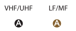
All IFR radio NAVAIDs that have been flight checked and are operational are shown on all IFR Enroute Charts. Very High Frequency/Ultrahigh Frequency (VHF/UHF) NAVAIDs, Very high frequency Omnidirectional Radio range (VORs), Tactical Air Navigation (TACANs) are shown in black, and Low Frequency/Medium Frequency (LF/MF) NAVAIDs, (Compass Locators and Aeronautical or Marine NDBs) are shown in brown.
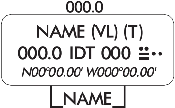
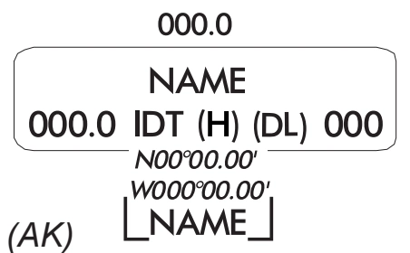
On IFR Enroute Charts, information about NAVAIDs is boxed as illustrated below. To avoid duplication of data, when two or more NAVAIDs in a general area have the same name, the name is usually printed only once inside an identification box with the frequencies, TACAN channel numbers, identification letters, or Morse Code Identifications of the different NAVAIDs are shown in appropriate colors.
NAVAIDs in a shutdown status have the frequency and channel number crosshatched. Use of the NAVAID status "shutdown" is only used when a facility has been decommissioned but cannot be published as such because of pending airspace actions.
Navigation and Communication Boxes - Common Elements
LOW ENROUTE CHARTS
RCO Frequencies
NAVAID Name, SSV(s)
FREQ, Ident, CH, Morse Code
Latitude, Longitude
Controlling FSS Radio or FSS Name (AK) | HIGH ENROUTE CHARTS
RCO Frequencies
NAVAID Name
Frequency, Ident, SSV(s), Channel
Latitude, Longitude
Controlling FSS Radio or FSS Name (AK)
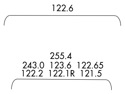
COMMON ELEMENTS (HIGH AND LOW CHARTS)
RCO FREQUENCY
Single Frequency
Multiple Frequencies
Frequencies transmit and receive except those followed by R and T:
R - Receive Only; T - Transmit Only |
NAVAID BOX
Thin line NAVAID boxes without frequency(s) and FSS radio name indicates no FSS frequencies available.
(AK only) Shadow NAVAID box indicates NAVAID and Flight Service Station (FSS) have same name. | VHF/UHF LF/MF
DISTANCE MEASURING EQUIPMENT
Facilities that operate in the “Y” mode for DME reception | (Y)
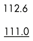
VOICE COMMUNICATIONS VIA NAVAID
Voice Transmitted
No Voice Transmitted |
NAVAID SHUTDOWN STATUS | VHF/UHF LF/MF
PART TIME OR ON-REQUEST | VHF/UHF LF/MF
AUTOMATED WEATHER BROADCAST SERVICES
ASOS/AWOS - Automated Surface Observing Station/Automated Weather Observing Station | Automated weather, when available, is broadcast on the associated NAVAID frequency.
LATITUDE AND LONGITUDE
Latitude and Longitude coordinates are provided for those NAVAIDs that make up part of a route/airway or a holding pattern.
All TACAN facilities will include geographic coordinates. |
Low-enroute navigation/communication-box common elements — source page 65.
High-enroute navigation/communication-box common elements — source page 65.
RCO-frequency common elements — single and multiple formats — source page 65.
NAVAID boxes — thin/shadow VHF/UHF and LF/MF variants — source page 65.
RADIO AIDS TO NAVIGATION All IFR radio NAVAIDs that have been flight checked and are operational are shown on all IFR Enroute Charts. Very High Frequency/Ultrahigh Frequency (VHF/UHF) NAVAIDs, Very high frequency Omnidirectional Radio range (VORs), Tactical Air Navigation (TACANs) are shown in black, and Low Frequency/Medium Frequency (LF/MF) NAVAIDs, (Compass Locators and Aeronautical or Marine NDBs) are shown in brown. On IFR Enroute Charts, information about NAVAIDs is boxed as illustrated below. To avoid duplication of data, when two or more NAVAIDs in a general area have the same name, the name is usually printed only once inside an identification box with the frequencies, TACAN channel numbers, identification letters, or Morse Code Identifications of the different NAVAIDs are shown in appropriate colors. NAVAIDs in a shutdown status have the frequency and channel number crosshatched. Use of the NAVAID status "shutdown" is only used when a facility has been decommissioned but cannot be published as such because of pending airspace actions. NAVIGATION AND COMMUNICATION BOXES - COMMON ELEMENTS LOW ENROUTE CHARTS RCO Frequencies NAVAID Name, SSV(s) FREQ, Ident, CH, Morse Code Latitude, Longitude Controlling FSS Radio or FSS Name (AK) HIGH ENROUTE CHARTS RCO Frequencies NAVAID Name Frequency, Ident, SSV(s), Channel Latitude, Longitude Controlling FSS Radio or FSS Name (AK) COMMON ELEMENTS (HIGH AND LOW CHARTS) RCO FREQUENCY Single Frequency Multiple Frequencies Frequencies transmit and receive except those followed by R and T: R - Receive Only T - Transmit Only NAVAID BOX Thin line NAVAID boxes without frequency(s) and FSS radio name indicates no FSS frequencies available. (AK only) Shadow NAVAID box indicates NAVAID and Flight Service Station (FSS) have same name. VHF/UHF LF/MF
Source page 66
NAVAID Standard Service Volume (SSV) Classifications
SSV Class | Altitudes | Distance (NM)
(T) Terminal | 1000’ to 12,000’ | 25
(L) Low Altitude | 1000’ to 18,000’ | 40
(H) High Altitude | 1000’ to 14,500’
14,500’ to 18,000’
18,000’ to 45,000’
45,000’ to 60,000’ | 40
100
130
100
(VL) VOR Low | 1000’ to 5,000’
5,000’ to 18,000’ | 40
70
(VH) VOR High | 1000’ to 5,000’
5,000’ to 14,500’
14,500’ to 18,000’
18,000’ to 45,000’
45,000’ to 60,000’ | 40
70
100
130
100
(DL) DME Low & (DH) DME High* | 1000’ to 12,900’ | 40 increasing to 130
(DL) DME Low | 12,900’ to 18,000’ | 130
(DH) DME High | 12,900’ to 45,000’
45,000’ to 60,000’ | 130
100
* Between 1000’ to 12,900’, DME service volume follows a parabolic curve used by flight managment computers.
Notes: For NAVAIDs with two SSVs, the SSV for each component is shown in paired parentheses with the VOR SSV shown first followed by the DME or TACAN SSV. Additionally, High Altitude facilities provide Low Altitude and Terminal service volume and Low Altitude facilities provide Terminal service volume. Altitudes are with respect to the station’s site elevation. Coverage is not available in a cone of airspace directly above the facility. In some cases local conditions (terrain, buildings, trees, etc.) may require that the service volume be restricted. The public shall be informed of any such restriction by a remark in the NAVAID entry or by a NOTAM.
Voice communications via NAVAID — 112.6 voice; underlined 111.0 no voice — source page 66.
NAVAID shutdown status — VHF/UHF and LF/MF — source page 66.
Part-time/on-request NAVAIDs — VHF/UHF and LF/MF — source page 66.
ASOS/AWOS indicators — VHF/UHF and LF/MF — source page 66.
NAVAID latitude/longitude formats — low/high enroute — source page 66.
NAVAID STANDARD SERVICE VOLUME (SSV) CLASSIFICATIONS SSV Class Altitudes Distance (NM) (T) Terminal 1000’ to 12,000’ 25 (L) Low Altitude 1000’ to 18,000’ 40 (H) High Altitude 1000’ to 14,500’ 14,500’ to 18,000’ 18,000’ to 45,000’ 45,000’ to 60,000’ 40 100 130 100 (VL) VOR Low 1000’ to 5,000’ 5,000’ to 18,000’ 40 70 (VH) VOR High 1000’ to 5,000’ 5,000’ to 14,500’ 14,500’ to 18,000’ 18,000’ to 45,000’ 45,000’ to 60,000’ 40 70 100 130 100 (DL) DME Low & (DH) DME High* 1000’ to 12,900’ 40 increasing to 130 (DL) DME Low 12,900’ to 18,000’ 130 (DH) DME High 12,900’ to 45,000’ 45,000’ to 60,000’ 130 100 * Between 1000’ to 12,900’, DME service volume follows a parabolic curve used by flight managment computers. Notes: For NAVAIDs with two SSVs, the SSV for each component is shown in paired parentheses with the VOR SSV shown first followed by the DME or TACAN SSV. Additionally, High Altitude facilities provide Low Altitude and Terminal service volume and Low Altitude facilities provide Terminal service volume. Altitudes are with respect to the station’s site elevation. Coverage is not available in a cone of airspace directly above the facility. In some cases local conditions (terrain, buildings, trees, etc.) may require that the service volume be restricted. The public shall be informed of any such restriction by a remark in the NAVAID entry or by a NOTAM. DISTANCE MEASURING EQUIPMENT Facilities that operate in the “Y” mode for DME reception (Y) VOICE COMMUNICATIONS VIA NAVAID Voice Transmitted No Voice Transmitted NAVAID SHUTDOWN STATUS VHF/UHF LF/MF PART TIME OR ON-REQUEST VHF/UHF LF/MF AUTOMATED WEATHER BROADCAST SERVICES ASOS/AWOS - Automated Surface Observing Station/Automated Weather Observing Station VHF/UHF LF/MF Automated weather, when available, is broadcast on the associated NAVAID frequency. LATITUDE AND LONGITUDE Latitude and Longitude coordinates are provided for those NAVAIDs that make up part of a route/airway or a holding pattern. All TACAN facilities will include geographic coordinates. LOW ENROUTE HIGH ENROUTE
Source page 67
AIRSPACE INFORMATION
CONTROLLED AIRSPACE
Cookie Preferences
We use cookies to operate this website, improve performance, understand site traffic, and personalize your experience. Essential cookies are always active because they are required for the website to function.
Required for basic site functionality and security.
Help us understand how visitors use the website so we can improve it.
May be used for advertising, remarketing, or social media features.
You can update your choices anytime using Cookie Settings. View Privacy Policy