Searchable explanations of IFR enroute airports, radio aids, airspace, airways, foreign areas, and terrain contours.
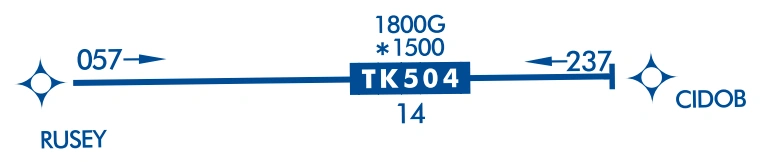
RNAV TK helicopter route TK504 — source page 70.
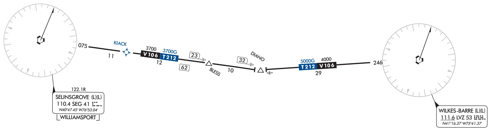
Joint Victor/RNAV routes are charted as outlined above except as noted. The joint Victor route and the RNAV route identification boxes are shown adjacent to each other. Magnetic reference courses are not shown. MEAs are charted above the appropriate identification box or stacked in pairs, GNSS and Victor. On joint routes, RNAV specific information will be printed in blue.
Joint Victor/RNAV route chart example — source page 70.
UNUSABLE AIRWAY/ROUTE SEGMENTS
Airway/Route segments designated by the FAA as unusable will be depicted as shown below.
Unusable airway/route-segment chart example — source page 70.
Unusable Victor Route
Pilots should not file a flight plan for or accept a clearance that includes navigation on any route or route segment depicted as unusable. Pilots using RNAV may request ATC clearance to fly point-to-point between valid waypoints or fixes, even those on routes depicted as unusable (refer to AC 90-108 for RNAV eligibility).
AREA NAVIGATION (RNAV) "T" ROUTE SYSTEM The FAA has created new low altitude area navigation (RNAV) "T" routes for the enroute and terminal environments. The RNAV routes will provide more direct routing for IFR aircraft and enhance the safety and efficiency of the National Airspace System. To utilize these routes aircraft are required to be equipped with IFR approved GNSS. In Alaska, TSO-145a and 146a equipment is required. Low altitude RNAV only routes are identified by the prefix "T", and the prefix "TK" for RNAV helicopter routes followed by a three digit number (T-200 to T-500). Routes are depicted in blue on the IFR Enroute Low Altitude Charts. RNAV route data (route line, identification boxes, mileages, waypoints, waypoint names, magnetic reference courses and MEAs) will also be printed in blue. Magnetic reference courses will be shown originating from a waypoint, fix/reporting point or NAVAID. GNSS MEA for each segment is established to ensure obstacle clearance and communications reception. GNSS MEAs are identified with a "G" suffix. Joint Victor/RNAV routes are charted as outlined above except as noted. The joint Victor route and the RNAV route identification boxes are shown adjacent to each other. Magnetic reference courses are not shown. MEAs are charted above the appropriate identification box or stacked in pairs, GNSS and Victor. On joint routes, RNAV specific information will be printed in blue. UNUSABLE AIRWAY/ROUTE SEGMENTS Airway/Route segments designated by the FAA as unusable will be depicted as shown below. Unusable Victor Route Pilots should not file a flight plan for or accept a clearance that includes navigation on any route or route segment depicted as unusable. Pilots using RNAV may request ATC clearance to fly point-to-point between valid waypoints or fixes, even those on routes depicted as unusable (refer to AC 90-108 for RNAV eligibility).
Source page 71
Coincident Airways/Routes with Unusable Segment
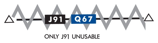
When two airways/routes are coincident, but only one airway/route is designated as unusable, the following note indicating which airway the unusable symbology applies to will be placed in close proximity to the airway/route identifiers.
Coincident J91/Q67 routes — only J91 unusable — source page 71.
OFF ROUTE OBSTRUCTION CLEARANCE ALTITUDE (OROCA)
The Off Route Obstruction Clearance Altitude (OROCA) is depicted on IFR Enroute Low Altitude and Pacific charts and is represented in thousands and hundreds of feet above MSL. OROCAs are shown in every 30 x 30 minute quadrant on Area Charts, every one degree by one degree quadrant for IFR Enroute Low Altitude Charts - U.S. and every two de¬gree by two degree quadrant on IFR Enroute Low Altitude Charts - Alaska. The OROCA is based on the highest known terrain feature or obstruction in each quadrangle, bounded by the ticked lines of latitude/longitude including data 4 NM outside the quadrant. In this example the OROCA represents 12,500 feet.
OROCA is computed just as the Maximum Elevation Figure (MEF) found on Visual Flight Rule (VFR) Charts except that it provides an additional vertical buffer of 1,000 feet in designated non-mountainous areas and a 2,000 foot vertical buffer in designated mountainous areas within the United States. Evaluating the area around the quadrant provides the chart user the same lateral clearance an airway provides should the line of intended flight follow a ticked line of latitude or longitude. OROCA altitudes are not assessed for NAVAID signal coverage, air traffic control surveillance, or communications coverage, and are published for general situational awareness, flight planning, and in-flight contingency use. OROCAs can be found over all land masses and open water areas containing man-made obstructions (such as oil rigs).
OROCA — 12,500 ft — source page 71.
MILITARY TRAINING ROUTES (MTRs)
Military Training Routes (MTRs) are routes established for the conduct of low-altitude, high-speed military flight training (generally below 10,000 feet MSL at airspeeds in excess of 250 knots Indicated Air Speed). These routes are depicted in brown on IFR Enroute Low Altitude Charts, and are not shown on inset charts or on IFR Enroute High Altitude Charts. IFR Enroute Low Altitude Charts depict all IFR Military Training Routes (IRs) and VFR Military Training Routes (VRs), except those VRs that are entirely at or below 1,500 feet AGL.
MTRs are identified by designators (IR-107, VR-134) that are shown in brown on the route centerline. Arrows are shown to indicate the direction of flight along the route. The width of the route determines the width of the line that is plotted on the chart:
Cookie Preferences
We use cookies to operate this website, improve performance, understand site traffic, and personalize your experience. Essential cookies are always active because they are required for the website to function.
Required for basic site functionality and security.
Help us understand how visitors use the website so we can improve it.
May be used for advertising, remarketing, or social media features.
You can update your choices anytime using Cookie Settings. View Privacy Policy